BristolKeynsham

Brikey two
Verified route

Verified Slow Way

Verified by 80.00% of reviewers

By danravenellison on 03 May 2022


Distance

10km/6mi

Ascent

-

Descent

-

Download this route

Are you sure you want to download this route?

Using a GPX file for the first time?

No, back to route

Give a hike

Pledge to walk this route and help firm up its place in the network - every walk helps.

So far it has been reviewed by five people and surveyed by one person and there is one issue flagged with this route.

One person has pledged to review this route.

Your pledged routes will show up in your pledges Waylist.

Every review and survey pledged and then walked will help make the Slow Ways network better, thank you for your help!

Sign up or log in to pledge to walk this route.

Back to route

Save to Waylist

Sign up or log in to save this route so you can find it more easily or plan a longer journey.

More options

Save to my account

Sign up or log in to save this route so you can find it more easily or plan a longer journey.

Print (via Inkatlas)

Survey this route

Review this route

Suggest a better route

Report a problem

Description

This route is very similar to Brikey One, but makes the improvements that the (two) reviewers have suggested.

I've not walked this route. I decided to go via the river instead, which is only a little bit further but a lot more green, blue, quiet and easy to navigate. That will be Brikey Three. Someone will likely be able to suggest another route that is far more direct, but with much more nearby traffic

Status

This route has been reviewed by 5 people.

This route has been flagged (1 times) for reasons relating to safety.

Photos for Brikey two

Photos of this route will appear when they are added to a review. You can review this route here.


Information

Verified route

Route status - Live

Reviews - 5

Average rating -

Is this route good enough? -  Yes (4) No (1)

Problems reported -  Safety (1)

Downloads - 5

Surveys

What is this route like?

Surveys are submitted by fellow users of this website and show what you might expect from this Slow Ways route. Scroll down the page to read more detailed surveys.

Grade 4X based on 1 surveys Sign up or log in to survey this route.
Description Note
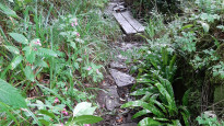
Grade 4: Route includes very rough surfaces including deep ruts, steep loose gravel, unmade paths and deep muddy sections. Wheelchairs may experience traction/wheel spin issues.
Access grade X: At least one stile, flight of steps or other obstacle that is highly likely to block access for wheelchair and scooter users.
Grading is based on average scores by surveyors. This slow way has 1 surveys.
Full grading description

Only people who have completed our training can become Slow Ways surveyors and submit a survey. We do not vet contributors, so we cannot guarantee the quality or completeness of the surveys they complete. If you are dependent on the information being correct we recommend reading and comparing surveys before setting off.

Survey Photos

Facilities

Facilities in the middle third of this route.

Present at time of survey Public toilet (1)
Maybe present Wheelchair accessible toilet (1)
Present at time of survey Supermarket (1)
Present at time of survey Restaurant (1)
Maybe present Vegan restaurant (1)
Maybe present Accommodation (1)
Maybe present Accommodation < £50 (1)
Not present at time of survey Campsite (1)
Not present at time of survey Bothy (1)
Not present at time of survey Free wifi (1)
Maybe present Public phone (1)
Present at time of survey Mobile phone coverage (1)
Not present at time of survey Train station (1)
Not present at time of survey Bench (1)
Not present at time of survey Picnic table (1)
Present at time of survey Bus stop (1)
Not present at time of survey Ferry (1)

Challenges

Potential challenges reported on this route. Some challenges are seasonal.

Not present at time of survey Scrambling (1)
Not present at time of survey Wading (1)
Not present at time of survey Swimming (1)
Not present at time of survey Climbing (1)
Not present at time of survey Stepping stones (1)
Maybe present Very slippery (1)
Present at time of survey Very muddy (1)
Maybe present Very icy (1)
Maybe present Likely to flood (1)
Present at time of survey Long grass sections (1)
Maybe present Crops encroaching on path (1)
Present at time of survey Diverted path (1)

Obstacles

Obstacles on this route.

Present at time of survey Stiles (1)
Present at time of survey Step and kerbs (1)
Not present at time of survey Possible to avoid steps, if applicable (1)
Present at time of survey Flights of steps (1)
Present at time of survey Gates (1)
Present at time of survey Kissing gates (1)
Not present at time of survey Locked gates (1)
Not present at time of survey Disables access gates (1)
Present at time of survey Cycle barriers (1)
Not present at time of survey Ladders (1)
Not present at time of survey Cattle grids (1)
Not present at time of survey Fords (1)
Present at time of survey Narrow bridges (1)
Not present at time of survey Ferry required (1)
Maybe present Acceptable road walking (1)
Maybe present Unacceptable road walking (1)
Present at time of survey Dangerous road crossings (1)
Present at time of survey Walking on paths beside roads (1)
Not present at time of survey Walking on verges beside roads (1)
Not present at time of survey Railway crossings (1)
Not present at time of survey River crossings (1)
Present at time of survey Cattle possible (1)
Not present at time of survey Horses possible (1)
Not present at time of survey Tidal area (1)
Present at time of survey Potential falls (1)
Present at time of survey Exposed to elements (1)
Not present at time of survey Remote area (1)
Not present at time of survey Mountainous area (1)
Not present at time of survey Military training area (1)
Present at time of survey No visible path (1)
Present at time of survey Seasonal nesting birds (1)
Maybe present Other hazards (1)

Accessibility

Is this route step and stile free?

Not present at time of survey Free of stiles (1)
Not present at time of survey Free of single steps/kerbs (1)
Not present at time of survey Free of flights of steps (1)
Not present at time of survey Free of other obstacles (1)

Measurements

Surveyors were asked to measure the narrowest and steepest parts of paths.

The narrowest part of the path is 50.0cm (1)

The steepest uphill gradient walking East 27.0% (1)

The steepest uphill gradient walking West 31.0% (1)

The steepest camber: no data

How clear is the waymarking on the route: Unclear in places (1)

Successfully completed

We asked route surveyors "Have you successfully completed this route with any of the following? If so, would you recommend it to someone with the same requirements?". Here is how they replied.

Small Pug-sized dog (0)
Small Labrador-sized dog (0)
Large St. Bernard-sized dog (0)
Standard pram (0)
Off-road rugged pram (0)
Standard wheelchair (0)
Off-road rugged wheelchair (0)
Standard mobility scooter (0)
Off-road rugged mobility scooter (0)

Recommended by an expert

We asked route surveyors "Are you a trained access professional, officer or expert? If so, is this route suitable for someone travelling with any of the following?" Here is how they replied.

Small Pug-sized dog (0)
Small Labrador-sized dog (0)
Large St. Bernard-sized dog (0)
Standard pram (0)
Off-road rugged pram (0)
Standard wheelchair (0)
Off-road rugged wheelchair (0)
Standard mobility scooter (0)
Off-road rugged mobility scooter (0)

Terrain

We asked route surveyors to estimate how much of the route goes through different kinds of terrain.

There is no data on how much of this route is on roads

There is no data on how much of this route is lit at night

Thereis no data on amount of route paved

There is no data on muddiness

There is no data on rough ground

There is no data on long grass

Report a problem with this data

1 surveys

Information from verified surveys.

4X October 2023 by Mary Oz
Read survey

Sign up or log in to get the link to survey this route for Brikey.

Geography information system (GIS) data

Total length

Maximum elevation

Minimum elevation

Start and end points

Bristol
Grid Ref ST5894073546
Lat / Lon 51.45939° / -2.59239°
Easting / Northing 358,940E / 173,546N
What3Words dollar.perky.study
Keynsham
Grid Ref ST6547768493
Lat / Lon 51.41439° / -2.49780°
Easting / Northing 365,477E / 168,493N
What3Words preoccupied.grape.launch

Sorry Land Cover data is not currently available for this route. Please check back later.

reviews


Sign up or log in to review this route for Brikey.

Overall ratings

5 reviews


3 reviews

1 reviews

1 reviews

0 reviews

0 reviews

Show all


Other Routes for Bristol—Keynsham See all Slow Ways

Bristol—Keynsham

Brikey one

Distance

11km/7mi

Ascent

155 m

Descent

164 m

Bristol—Keynsham

Brikey three

Distance

12km/7mi

Ascent

-

Descent

-

Review this better route and help establish a trusted network of walking routes.

Suggest a better route if it better meets our methodology.

See all routes from Bristol.

See all routes from Keynsham.