Bridgwater — Burnham-on-Sea
Bribur two

Verified Slow Way
Verified by 100.00% of reviewers
Verified Slow Way
Verified by 100.00% of reviewers
By Mockymock on 22 Mar 2023
Description
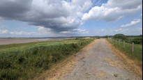
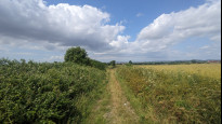
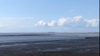
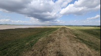
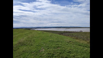
Scenic and far more off-road route in the main section between Bridgwater and Highbridge. Much of this Slow Way is along the sea wall of the River Parrett as it heads out into Bridgwater Bay. Less than a mile longer than Bribur one.
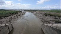
Note that the access to the England Coast Path along the RIver Parrett from the main road bridge in Bridgwater has changed very slightly from the plotted route as the path has recently been upgraded. Best access to the path going north out of town (signed) is now from the north-eastern side of the bridge
Scenic and far more off-road route in the main section between Bridgwater and Highbridge. Much of this Slow Way is along the sea wall of the River Parrett as it heads out into Bridgwater Bay. Less than a mile longer than Bribur one.
Note that the access to the England Coast Path along the RIver Parrett from the main road bridge in Bridgwater has changed very slightly from the plotted route as the path has recently been upgraded. Best access to the path going north out of town (signed) is now from the north-eastern side of the bridge
Status
This route has been reviewed by 3 people.
There are no issues flagged.
Photos for Bribur two


Photos of this route will appear when they are added to a review. You can review this route here.
Information
Route status - Live
Reviews - 3
Average rating -
Is this route good enough? - Yes (3)
There are currently no problems reported with this route.
Downloads - 5
Surveys
We are working to build-up a picture of what routes look like. To do that we are asking volunteers to survey routes so that we can communicate features, obstacles and challenges that may make a route desirable or not.
Slow Ways surveyors are asked to complete some basic online training, but they are not vetted. If you are dependent on the survey information being correct in order to complete a route, we recommend that you think critically about the information provided. You may also wish to wait until more than one survey has been completed.
Help people know more about this route by volunteering to submit a survey.
- Complete the survey training.
- Submit a survey for this route.
Geography information system (GIS) data
Total length
Maximum elevation
Minimum elevation
Start and end points
Bridgwater
Grid Ref
ST2987237046
Lat / Lon
51.12838° / -3.00354°
Easting / Northing
329,872E / 137,046N
What3Words
rails.skyrocket.chin
Burnham-on-Sea
Grid Ref
ST3031648824
Lat / Lon
51.23432° / -2.99949°
Easting / Northing
330,316E / 148,824N
What3Words
mostly.saved.bets
| Bridgwater | |
|---|---|
| Grid Ref | ST2987237046 |
| Lat / Lon | 51.12838° / -3.00354° |
| Easting / Northing | 329,872E / 137,046N |
| What3Words | rails.skyrocket.chin |
| Burnham-on-Sea | |
|---|---|
| Grid Ref | ST3031648824 |
| Lat / Lon | 51.23432° / -2.99949° |
| Easting / Northing | 330,316E / 148,824N |
| What3Words | mostly.saved.bets |
Sorry Land Cover data is not currently available for this route. Please check back later.
Other Routes for Bridgwater—Burnham-on-Sea See all Slow Ways
Review this better route and help establish a trusted network of walking routes.
Suggest a better route if it better meets our methodology.