Bridgwater — Burnham-on-Sea
Bribur two

Verified Slow Way
Verified by 100.00% of reviewers
Verified Slow Way
Verified by 100.00% of reviewers
By Mockymock on 22 Mar 2023
Description
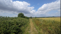
Scenic and far more off-road route in the main section between Bridgwater and Highbridge. Much of this Slow Way is along the sea wall of the River Parrett as it heads out into Bridgwater Bay. Less than a mile longer than Bribur one.
Note that the access to the England Coast Path along the RIver Parrett from the main road bridge in Bridgwater has changed very slightly from the plotted route as the path has recently been upgraded. Best access to the path going north out of town (signed) is now from the north-eastern side of the bridge
Status
This route has been reviewed by 3 people.
There are no issues flagged.
Photos for Bribur two


Photos of this route will appear when they are added to a review. You can review this route here.
Information
Route status - Live
Reviews - 3
Average rating -
Is this route good enough? - Yes (3)
There are currently no problems reported with this route.
Downloads - 5
Surveys
We are working to build-up a picture of what routes look like. To do that we are asking volunteers to survey routes so that we can communicate features, obstacles and challenges that may make a route desirable or not.
Slow Ways surveyors are asked to complete some basic online training, but they are not vetted. If you are dependent on the survey information being correct in order to complete a route, we recommend that you think critically about the information provided. You may also wish to wait until more than one survey has been completed.
Help people know more about this route by volunteering to submit a survey.
- Complete the survey training.
- Submit a survey for this route.
Geography information system (GIS) data
Total length
Maximum elevation
Minimum elevation
Start and end points
Bridgwater
Grid Ref
ST2987237046
Lat / Lon
51.12838° / -3.00354°
Easting / Northing
329,872E / 137,046N
What3Words
rails.skyrocket.chin
Burnham-on-Sea
Grid Ref
ST3031648824
Lat / Lon
51.23432° / -2.99949°
Easting / Northing
330,316E / 148,824N
What3Words
mostly.saved.bets
| Bridgwater | |
|---|---|
| Grid Ref | ST2987237046 |
| Lat / Lon | 51.12838° / -3.00354° |
| Easting / Northing | 329,872E / 137,046N |
| What3Words | rails.skyrocket.chin |
| Burnham-on-Sea | |
|---|---|
| Grid Ref | ST3031648824 |
| Lat / Lon | 51.23432° / -2.99949° |
| Easting / Northing | 330,316E / 148,824N |
| What3Words | mostly.saved.bets |
Sorry Land Cover data is not currently available for this route. Please check back later.
reviews
Danravenellison
19 Jun 2023I've just finished walking this route and really enjoyed it.
It's mostly off-road, almost entirely by water and very flat.
The views are great. On a rainy or windy day you'd be very exposed though..
It's super warm today and an ice cream van half way would have been welcome, but that's my only complaint.
Mockymocks review is great and I agree with Pilea (who I walked this with) too.
I'd 100% walk this route again.
Pilea
19 Jun 2023This is a great route! Mockymock has done a great job of sharing and reviewing it.
It's a really flat and easy to follow route. The views to the Quantocks, Mendips and out to sea are great.
I 100% recommend this route for walkers, but there are gates and pinch points that will make it hard for wheelers.
-
Mockymock
19 Jun 2023Thanks, and glad you enjoyed it. Seeing this route verified made my day!
-
Share your thoughts
Mockymock
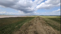
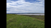
12 Sep 2022 (edited 22 Mar 2023)I loved this walk. It is a fine way to see the area. Much of the route is along the sea wall of the atmospheric River Parrett, which heads out from the busy industrial town of Bridgwater and offers ever more widening views out over mud flats and salt marshes to the Quantock Hills, the Somerset coast, Brent Knoll and the Bristol Channel.
It exits the curious old Dutch-referenced Bridgwater Quay using a cycle path and footpath along the quieter west bank of the reedy river as far as the main road bridge where it swaps to a newly upgraded paved multiuser path on the east bank. Note that there is new signed access to this path from the northeast side of the bridge. This differs from the plot of the route, which predates the upgrade and indicates the old access on the southwest side.
From here the Slow Way follows on up the river along this path and then a gravelly track up to Dunball wharf, where it briefly joins the path alongside the dual carriageway to get around the wharf before turning in again through a trading estate to rejoin the river path. Follow the signs for the England Coast Path.
The route continues along the river wall for a while longer (with lots of gates to open and shut) before turning off it at Brickyard Farm, where it heads uphill towards Pawlett, and skirts the village using quiet lanes and a pleasant bridleway before regaining the coast path further up via a footpath across some fields.
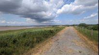
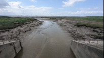
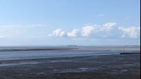
The next few miles up to Burnham is a lovely walk along the sea wall using the England Coast Path, with expansive views across the Parrett Estuary and out into Bridgwater Bay, with a kink in to the edge of Highbridge to get across the mouth of the River Brue over the sluice gate. Just beyond this is a very narrow alleyway which zig-zags round the backs of the houses. This isn't the most visible. Just keep going west towards the end of the road past the houses. The remainder of the route into the fish, chips and beachside entertainment zone of Burnham’s old-fashioned seafront is along another gravelled cycle path.
The whole route is pretty easy to walk and navigate as most of it is flat and most of it goes along the signed England Coast Path. A fair amount of it is also obstacle free, though there are sections with farm gates.
This route lacks the pub stop possibilities of Bribur One but there is a motorway services just off the route by the A39 roundabout at Dunball on the edge of Bridgwater, and shops nearby if you walk into Highbridge. In my opinion it is best to carry any refreshments you need and enjoy the uninterrupted coastal walking.
-
Share your thoughts
Share your views about this route, give it a star rating, indicate whether it should be verified or not.
Include information that will be useful to others considering to walk or wheel it.
You can add up to 15 photos.
Other Routes for Bridgwater—Burnham-on-Sea See all Slow Ways
Review this better route and help establish a trusted network of walking routes.
Suggest a better route if it better meets our methodology.
Share your thoughts