Description
Beclow One has a couple of issues in that the route doesn't track well to a map. Additionally it seems to follow (but shifted) a number of civil parish boundaries rather than footpaths. This alternative walks between Beccles and Oulton Broad on the established Angles Way and then crosses through to Lowestoft on local paths and residential roads. It could be made a little shorter by crossing east through Beccles and taking marsh road after Worlingham to meet the Angles Way
Beclow One has a couple of issues in that the route doesn't track well to a map. Additionally it seems to follow (but shifted) a number of civil parish boundaries rather than footpaths. This alternative walks between Beccles and Oulton Broad on the established Angles Way and then crosses through to Lowestoft on local paths and residential roads. It could be made a little shorter by crossing east through Beccles and taking marsh road after Worlingham to meet the Angles Way
Status
This route has been reviewed by 1 person.
There are no issues flagged.
Photos for Beclow two


Photos of this route will appear when they are added to a review. You can review this route here.
Information

Route status - Live
Reviews - 1
Average rating -
Is this route good enough? - Yes (1)
There are currently no problems reported with this route.
Downloads - 1
Surveys
We are working to build-up a picture of what routes look like. To do that we are asking volunteers to survey routes so that we can communicate features, obstacles and challenges that may make a route desirable or not.
Slow Ways surveyors are asked to complete some basic online training, but they are not vetted. If you are dependent on the survey information being correct in order to complete a route, we recommend that you think critically about the information provided. You may also wish to wait until more than one survey has been completed.
Help people know more about this route by volunteering to submit a survey.
- Complete the survey training.
- Submit a survey for this route.
Geography information system (GIS) data
Total length
Maximum elevation
Minimum elevation
Start and end points
Beccles
Grid Ref
TM4222090329
Lat / Lon
52.45718° / 1.56382°
Easting / Northing
642,221E / 290,329N
What3Words
bypasses.ourselves.freed
Lowestoft
Grid Ref
TM5476692892
Lat / Lon
52.47447° / 1.75001°
Easting / Northing
654,766E / 292,892N
What3Words
issues.couple.report
| Beccles | |
|---|---|
| Grid Ref | TM4222090329 |
| Lat / Lon | 52.45718° / 1.56382° |
| Easting / Northing | 642,221E / 290,329N |
| What3Words | bypasses.ourselves.freed |
| Lowestoft | |
|---|---|
| Grid Ref | TM5476692892 |
| Lat / Lon | 52.47447° / 1.75001° |
| Easting / Northing | 654,766E / 292,892N |
| What3Words | issues.couple.report |
Sorry Land Cover data is not currently available for this route. Please check back later.
review
Truffle
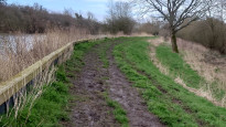
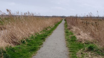
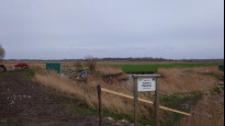
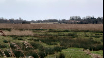
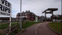
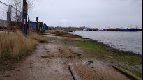
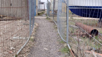
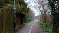
02 Mar 2024This walk is on footpaths - paved and unpaved with varying conditions in winter. At the Beccles end we had to deviate a little given a bit of flooding near the boat yard but it was along a paved (still slightly flooded path) rather than crossing the playground area and very close. In Beccles there is everything you need and by the boat yard there are public toilets. There isn't much in the way of facilities then until the Carlton marshes visitor centre. The footpath is winding and shrub lined for part of the way and winds along the river and by grazing marsh. It's a little exposed to the elements so dress accordingly. In early march it was a bit muddy and slippy between the boat yard and the marsh road turn off (probably a circular walk from town) so the suggestion for an alternative in the description might be worth it if you know it's rained a lot. It was patchy mud at times after that but not too bad. We've walked this in late spring and it was fine. The paths are quite wide for the most part and evidence of people cycling the route. There are no stiles and only a few kissing gates towards Oulton Broad. There are a lot of places to get food and drink from the Carlton marshes visitor centre onwards - pubs, cafes, hotels etc. There was one path after you turn into the Carlton marsh that's clearly a footpath on the OS map and had a footpath plastic disk but we were not sure as the gate said private on the other side. There are multiple options here though for paths which are also all hard gravel so it was ok to slightly deviate. This was a nice stretch of path and there are bird hides, wildlife explanations and we saw great egrets, little egrets and all sorts of geese/ducks. The turnoff in Oulton Broad after crossing the river was a little hidden and the path was between high metal fences. It then passed through boat yards which was really interesting. It looks like the path could become a bit wet with the tide as there was a bit of seaweed. The path in the park was closed for work but there was a path through the trees by the water and there is the playing field also so not an issue. Largely flat and easy going walking. Would happily do again. Public transport to each end is easy - bus and train available.
Share your views about this route, give it a star rating, indicate whether it should be verified or not.
Include information that will be useful to others considering to walk or wheel it.
You can add up to 15 photos.
Other Routes for Beccles—Lowestoft See all Slow Ways
Review this better route and help establish a trusted network of walking routes.
Suggest a better route if it better meets our methodology.
Share your thoughts