Abergele — Kinmel Bay
Abekin three

Slow Way not verified yet. Verify Abekin here.
Slow Way not verified yet. Verify Abekin here.
By Hugh Hudson on 04 Jul 2023
Description
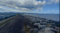
This route is almost the same as ABEKIN 1, but I have removed the unnecessary detour around Abergele & Pensarn station, and used a little more of the coast path at the Kinmel Bay end. I walked it today from Abergele to Kinmel Bay and enjoyed it
This route is almost the same as ABEKIN 1, but I have removed the unnecessary detour around Abergele & Pensarn station, and used a little more of the coast path at the Kinmel Bay end. I walked it today from Abergele to Kinmel Bay and enjoyed it
Status
This route has been reviewed by 2 people.
There are no issues flagged.
Photos for Abekin three


Photos of this route will appear when they are added to a review. You can review this route here.
Information
Route status - Live
Reviews - 2
Average rating -
Is this route good enough? - Yes (2)
There are currently no problems reported with this route.
Downloads - 0
Surveys
What is this route like?
Surveys are submitted by fellow users of this website and show what you might expect from this Slow Ways route. Scroll down the page to read more detailed surveys.
| Grade 1Y based on 1 surveys | Sign up or log in to survey this route. | ||
|---|---|---|---|
| Description | Note | ||
| Grade 1: Entirely smooth and compacted surfaces. Access grade Y: Stile, step and obstacle free. |
Grading is based on average scores by surveyors. This slow way has 1 surveys. | ||
| Full grading description | |||
Only people who have completed our training can become Slow Ways surveyors and submit a survey. We do not vet contributors, so we cannot guarantee the quality or completeness of the surveys they complete. If you are dependent on the information being correct we recommend reading and comparing surveys before setting off.
Survey Photos
Facilities
Facilities in the middle third of this route.
Challenges
Potential challenges reported on this route. Some challenges are seasonal.
Obstacles
Obstacles on this route.
Accessibility
Is this route step and stile free?
Measurements
Surveyors were asked to measure the narrowest and steepest parts of paths.
The narrowest part of the path is 100.0cm (1)
The steepest uphill gradient East: no data
The steepest uphill gradient West: no data
The steepest camber: no data
How clear is the waymarking on the route: Clear (1)
Successfully completed
We asked route surveyors "Have you successfully completed this route with any of the following? If so, would you recommend it to someone with the same requirements?". Here is how they replied.
Recommended by an expert
We asked route surveyors "Are you a trained access professional, officer or expert? If so, is this route suitable for someone travelling with any of the following?" Here is how they replied.
Terrain
We asked route surveyors to estimate how much of the route goes through different kinds of terrain.
There is no data on how much of this route is on roads
20.0% of the route is lit at night (1)
100.0% of the route is paved (1)
There is no data on muddiness
There is no data on rough ground
There is no data on long grass
Report a problem with this data
1 surveys
Information from verified surveys.
Geography information system (GIS) data
Total length
Maximum elevation
Minimum elevation
Start and end points
Abergele
Grid Ref
SH9440977592
Lat / Lon
53.28476° / -3.58531°
Easting / Northing
294,409E / 377,592N
What3Words
acrobats.bulky.toys
Kinmel Bay
Grid Ref
SH9886680411
Lat / Lon
53.31096° / -3.51938°
Easting / Northing
298,866E / 380,411N
What3Words
king.salads.tunes
| Abergele | |
|---|---|
| Grid Ref | SH9440977592 |
| Lat / Lon | 53.28476° / -3.58531° |
| Easting / Northing | 294,409E / 377,592N |
| What3Words | acrobats.bulky.toys |
| Kinmel Bay | |
|---|---|
| Grid Ref | SH9886680411 |
| Lat / Lon | 53.31096° / -3.51938° |
| Easting / Northing | 298,866E / 380,411N |
| What3Words | king.salads.tunes |
Sorry Land Cover data is not currently available for this route. Please check back later.
reviews
Dannywith
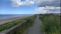
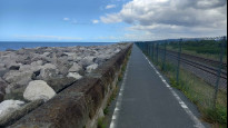
15 Apr 2024A fully accessible seaside route, on well surfaced paths and pavements along predominantly quieter roads. There are no steps to navigate, and as such is suitable for wheelchair users.
A large portion of Abekin Three follows the Wales Coastal Path, North Wales Path and National Cycle Route No.5, and cycling is actively encouraged throughout.
If using public transport, regular busses link the start and end points, or if like me and using trains, it is possible to walk from Rhyl to Abergele, crossing off two SlowWays in the process.
Hugh Hudson
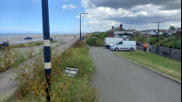
04 Jul 2023 (edited 05 Jul 2023)Walked from Abergele to Kinmel Bay. A good route, entirely on good surfaces with no steps or stiles. It used the coast path as much as possible. Mostly pleasant, though there are a lot of caravans and we pass close to a small funfair.
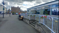
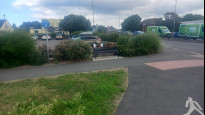
The route is very easy to follow. From Abergele, we follow Sea Road (with an optional slight detour through a park) out to the sea, then follow promenades, surfaced cycle tracks and minor roads along the coast. The route into Kinmel Bay leaves the coast path at a refreshment hut and passes a large Asda car park.
-
Share your thoughts
Share your views about this route, give it a star rating, indicate whether it should be verified or not.
Include information that will be useful to others considering to walk or wheel it.
You can add up to 15 photos.
Other Routes for Abergele—Kinmel Bay See all Slow Ways
Review this better route and help establish a trusted network of walking routes.
Suggest a better route if it better meets our methodology.
Share your thoughts