Wotton-under-Edge — Tetbury
Wottet one

Slow Way not verified yet. Verify Wottet here.
Slow Way not verified yet. Verify Wottet here.
By a Slow Ways Volunteer on 07 Apr 2021
Description
This is a Slow Ways route connecting Wotton-under-Edge and Tetbury.
Know of a better route? Share it here.
This is a Slow Ways route connecting Wotton-under-Edge and Tetbury.
Know of a better route? Share it here.
Status
This route has been reviewed by 3 people.
This route has been flagged (1 times) for reasons relating to access.
Photos for Wottet one


Photos of this route will appear when they are added to a review. You can review this route here.
Information
Route status - Live
Reviews - 3
Average rating -
Is this route good enough? - Yes (2) Maybe (1)
Problems reported - Access (1)
Downloads - 5
Surveys
We are working to build-up a picture of what routes look like. To do that we are asking volunteers to survey routes so that we can communicate features, obstacles and challenges that may make a route desirable or not.
Slow Ways surveyors are asked to complete some basic online training, but they are not vetted. If you are dependent on the survey information being correct in order to complete a route, we recommend that you think critically about the information provided. You may also wish to wait until more than one survey has been completed.
Help people know more about this route by volunteering to submit a survey.
- Complete the survey training.
- Submit a survey for this route.
Geography information system (GIS) data
Total length
Maximum elevation
Minimum elevation
Start and end points
Wotton-under-Edge
Grid Ref
ST7585093389
Lat / Lon
51.63878° / -2.35036°
Easting / Northing
375,850E / 193,389N
What3Words
sway.rejoins.search
Tetbury
Grid Ref
ST8906893130
Lat / Lon
51.63687° / -2.15935°
Easting / Northing
389,068E / 193,130N
What3Words
mysteries.madness.vague
Wottet One's land is
| Wotton-under-Edge | |
|---|---|
| Grid Ref | ST7585093389 |
| Lat / Lon | 51.63878° / -2.35036° |
| Easting / Northing | 375,850E / 193,389N |
| What3Words | sway.rejoins.search |
| Tetbury | |
|---|---|
| Grid Ref | ST8906893130 |
| Lat / Lon | 51.63687° / -2.15935° |
| Easting / Northing | 389,068E / 193,130N |
| What3Words | mysteries.madness.vague |
| Arable | 28.0% |
| Pasture | 51.3% |
| Urban | 11.8% |
| Woods | 8.8% |
Data: Corine Land Cover (CLC) 2018
reviews
Adeline
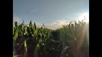
11 Aug 2023Overall a nice route, but seasonally some passages will be challenging:
- Between km 11 and 13 - early August '23 the trail was lost to corn crops.
- Leaving Tresham, the path in Walcroft Wood can be difficult to find. In the winter it gets muddy and slippery. A nicer way to come down will be to follow the Monarch's way from Tresham then right to Alderley.
Prhjones
25 Jul 2022A lovely and straightforward route from Wotton to Tetbury.
-
Share your thoughts
Patriciab
27 Nov 2021This is the route of the Monarch's Way. its an easy and scenic walk with great views from Tresham.
-
Share your thoughts
Share your views about this route, give it a star rating, indicate whether it should be verified or not.
Include information that will be useful to others considering to walk or wheel it.
You can add up to 15 photos.
There are no other routes for Wotton-under-Edge — Tetbury
If you know a better way, then please let us know.
Review this better route and help establish a trusted network of walking routes.
Suggest a better route if it better meets our methodology.
Share your thoughts