Description
Route mainly using the Caldon Canal. Some steps
Route mainly using the Caldon Canal. Some steps
Status
This route has been reviewed by 3 people.
There are no issues flagged.
Photos for Stolee three


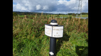


Photos of this route will appear when they are added to a review. You can review this route here.
Information
")
Route status - Live
Reviews - 3
Average rating -
Is this route good enough? - Yes (3)
There are currently no problems reported with this route.
Downloads - 1
Surveys
What is this route like?
Surveys are submitted by fellow users of this website and show what you might expect from this Slow Ways route. Scroll down the page to read more detailed surveys.
| Grade 2X based on 1 surveys | Sign up or log in to survey this route. | ||
|---|---|---|---|
| Description | Note | ||
| Grade 2: Mostly smooth and compacted surfaces, but there may be some loose gravel, muddy patches or cobbles. Access grade X: At least one stile, flight of steps or other obstacle that is highly likely to block access for wheelchair and scooter users. |
Grading is based on average scores by surveyors. This slow way has 1 surveys. | ||
| Full grading description | |||
Only people who have completed our training can become Slow Ways surveyors and submit a survey. We do not vet contributors, so we cannot guarantee the quality or completeness of the surveys they complete. If you are dependent on the information being correct we recommend reading and comparing surveys before setting off.
Survey Photos
Facilities
Facilities in the middle third of this route.
Challenges
Potential challenges reported on this route. Some challenges are seasonal.
Obstacles
Obstacles on this route.
Accessibility
Is this route step and stile free?
Measurements
Surveyors were asked to measure the narrowest and steepest parts of paths.
The narrowest part of the path is 120.0cm (1)
The steepest uphill gradient walking East 15.0% (1)
The steepest uphill gradient walking West 15.0% (1)
The steepest camber: no data
How clear is the waymarking on the route: Clear (1)
Successfully completed
We asked route surveyors "Have you successfully completed this route with any of the following? If so, would you recommend it to someone with the same requirements?". Here is how they replied.
Recommended by an expert
We asked route surveyors "Are you a trained access professional, officer or expert? If so, is this route suitable for someone travelling with any of the following?" Here is how they replied.
Terrain
We asked route surveyors to estimate how much of the route goes through different kinds of terrain.
There is no data on how much of this route is on roads
There is no data on how much of this route is lit at night
Thereis no data on amount of route paved
There is no data on muddiness
There is no data on rough ground
There is no data on long grass
Report a problem with this data
1 surveys
Information from verified surveys.
Geography information system (GIS) data
Total length
Maximum elevation
Minimum elevation
Start and end points
Stoke-on-Trent
Grid Ref
SJ8797145665
Lat / Lon
53.00818° / -2.18072°
Easting / Northing
387,971E / 345,665N
What3Words
habit.thank.water
Leek
Grid Ref
SJ9836756602
Lat / Lon
53.10662° / -2.02584°
Easting / Northing
398,367E / 356,602N
What3Words
printer.lamppost.remote
| Stoke-on-Trent | |
|---|---|
| Grid Ref | SJ8797145665 |
| Lat / Lon | 53.00818° / -2.18072° |
| Easting / Northing | 387,971E / 345,665N |
| What3Words | habit.thank.water |
| Leek | |
|---|---|
| Grid Ref | SJ9836756602 |
| Lat / Lon | 53.10662° / -2.02584° |
| Easting / Northing | 398,367E / 356,602N |
| What3Words | printer.lamppost.remote |
Sorry Land Cover data is not currently available for this route. Please check back later.
reviews
RGW
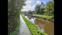
29 Oct 2023This is an excellent canal walk connecting the moorland town of Leek with the city of Stoke on Trent.
The path is very clear throughout and largely level (short ascent and descent where the canal goes through a tunnel).
Other reviewers have mentioned The Sportsman pub at Stockton Brook, I would also recommend the Hollybush at Denford which can be reached with a very minor detour where the Leek branch meets the Caldon canal.
Mary Oz
15 Oct 2023We left the charming market town of Leek, passing the Joliffe/Ash Almshouses at the main crossroads and then the Condlyffe Almshouses as we headed past the side of the cemetery. A short walk through an industrial estate brought us to a footpath to the towpath of the Caldon Canal at the current end of the Leek Branch. There were some information boards here about the canal. We soon arrived at a tunnel where we had to go up a slope to walk above the tunnel, then back down the other side. Unfortunately access back down to the towpath was via a staircase that I don’t think could be avoided.
The canal route was very pleasant and easy to follow, and made up 85% of the entire route. There was lots of interest including several lift bridges, the tunnel, a boatyard, a couple of locks, and views of the River Churnet, which was flooded in places. My favourite feature was the Hazelhurst Aqueduct, which is quite a significant structure taking one canal branch over the other.
We had very mixed weather, sunny a lot of the time, but there were also some heavy showers, including one bit of hail and thunder. Parts of the towpath were muddy with large puddles in places, as a consequence. We took advantage of several bridges to shelter from the worst moments.
There was a pub just off the route where the canal went under the A53, and also a rough picnic table near Milton towards the Stoke end.
This was a really enjoyable route, and was so easy to navigate that it was done in no time!.
-
Share your thoughts
David Sanderson
15 Oct 2023A very easy route to follow from Leek to Stoke. Mainly following the Caldon Canal, the route was relaxing and with barely any climbs. Starting in the pretty Moorlands town of Leek with its multiple shops, pubs and eateries, there's a very short walk down the main road of an industrial estate. A footpath then leads you to the canal. The route of the canal takes you through various landscapes, the Churnet Valley, and then through forest. There is a pub, "The Sportsman" just offroute near the halfway point at Stockton Brook. There are intriguing signs of old industry throughout. The canal into Stoke has a residential feel and is well used by locals. It seems that in no time you leave the canal to cross the busy and beautiful Hanley Park. The route to the meeting point is through an area adjacent to the University. There mutiple takeaways and an excellent Indian Sweet Shop. Based on greetings with strangers, this was one of the friendliest Slow Ways I've ever walked. Full marks!.
-
Share your thoughts
Share your views about this route, give it a star rating, indicate whether it should be verified or not.
Include information that will be useful to others considering to walk or wheel it.
You can add up to 15 photos.
Other Routes for Stoke-on-Trent—Leek See all Slow Ways
Review this better route and help establish a trusted network of walking routes.
Suggest a better route if it better meets our methodology.
Share your thoughts