Southwell (Notts) — Newark-on-Trent
Sounew one

Verified Slow Way
Verified by 100.00% of reviewers
Verified Slow Way
Verified by 100.00% of reviewers
By a Slow Ways Volunteer on 07 Apr 2021
Description
This is a Slow Ways route connecting Southwell (Notts) and Newark-on-Trent.
Know of a better route? Share it here.
This is a Slow Ways route connecting Southwell (Notts) and Newark-on-Trent.
Know of a better route? Share it here.
Status
This route has been reviewed by 3 people.
There are no issues flagged.
Photos for Sounew one


Photos of this route will appear when they are added to a review. You can review this route here.
Information
Route status - Live
Reviews - 3
Average rating -
Is this route good enough? - Yes (3)
There are currently no problems reported with this route.
Downloads - 8
Surveys
What is this route like?
Surveys are submitted by fellow users of this website and show what you might expect from this Slow Ways route. Scroll down the page to read more detailed surveys.
| Grade 3X based on 1 surveys | Sign up or log in to survey this route. | ||
|---|---|---|---|
| Description | Note | ||
| Grade 3: Route includes rough surfaces that may include small boulders, potholes, shallow ruts, loose gravel, short muddy sections. Access grade X: At least one stile, flight of steps or other obstacle that is highly likely to block access for wheelchair and scooter users. |
Grading is based on average scores by surveyors. This slow way has 1 surveys. | ||
| Full grading description | |||
Only people who have completed our training can become Slow Ways surveyors and submit a survey. We do not vet contributors, so we cannot guarantee the quality or completeness of the surveys they complete. If you are dependent on the information being correct we recommend reading and comparing surveys before setting off.
Survey Photos
Facilities
Facilities in the middle third of this route.
Challenges
Potential challenges reported on this route. Some challenges are seasonal.
Obstacles
Obstacles on this route.
Accessibility
Is this route step and stile free?
Measurements
Surveyors were asked to measure the narrowest and steepest parts of paths.
Narrowest part of path: no data
The steepest uphill gradient East: no data
The steepest uphill gradient West: no data
The steepest camber: no data
We don't have clear data on the waymarking (1)
Successfully completed
We asked route surveyors "Have you successfully completed this route with any of the following? If so, would you recommend it to someone with the same requirements?". Here is how they replied.
Recommended by an expert
We asked route surveyors "Are you a trained access professional, officer or expert? If so, is this route suitable for someone travelling with any of the following?" Here is how they replied.
Terrain
We asked route surveyors to estimate how much of the route goes through different kinds of terrain.
There is no data on how much of this route is on roads
There is no data on how much of this route is lit at night
Thereis no data on amount of route paved
There is no data on muddiness
There is no data on rough ground
There is no data on long grass
Report a problem with this data
1 surveys
Information from verified surveys.
Geography information system (GIS) data
Total length
Maximum elevation
Minimum elevation
Start and end points
Southwell (Notts)
Grid Ref
SK7003853842
Lat / Lon
53.07724° / -0.95597°
Easting / Northing
470,038E / 353,842N
What3Words
develop.screaming.oppose
Newark-on-Trent
Grid Ref
SK7995353844
Lat / Lon
53.07588° / -0.80799°
Easting / Northing
479,954E / 353,845N
What3Words
locker.pegs.refrained
Sounew One's land is
| Southwell (Notts) | |
|---|---|
| Grid Ref | SK7003853842 |
| Lat / Lon | 53.07724° / -0.95597° |
| Easting / Northing | 470,038E / 353,842N |
| What3Words | develop.screaming.oppose |
| Newark-on-Trent | |
|---|---|
| Grid Ref | SK7995353844 |
| Lat / Lon | 53.07588° / -0.80799° |
| Easting / Northing | 479,954E / 353,845N |
| What3Words | locker.pegs.refrained |
| Arable | 67.1% |
| Pasture | 16.7% |
| Urban | 16.3% |
Data: Corine Land Cover (CLC) 2018
reviews
Hugh Hudson
28 Dec 2022Walked from Southwell to Newark on a wet late December morning. No major issues, but the detour to the west of Staythorpe ignores two shorter easier paths and the clayfield yomp from Kelham Bridge to Newark rugby club is unpleasant and poorly waymarked, though unavoidable except by staying by the busy A617. I don't mind snailing this route but I can't say I enjoyed all of it. Full review and photos to follow.
Rob23Notts
28 Nov 2022This route is a mixture of road walking and paths through arable and grassy fields. The route is safe because the road sections are along pavement next to the roads.
Starting in Southwell you go past the Minster and along residential streets with a short walk through a nice grass field. Once out of Southwell cross fields and follow the road leading to the racecourse. The next mile follows paths and tracks across grassy fields by the river Greet. You go uphill along the road into Upton then down again across fields to Staythorpe. These paths are usually not too muddy.
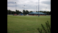
The section from Staythorpe to Kelham is all along pavement or walkway alongside roads. As far as Averham the road is relatively quiet but the A617 is busy for the kilometre to Kelham. After crossing the Trent in Kelham you leave the road to cross fields. There are waymarked yellow posts in places in these fields but the crops and clarity of the paths can vary. You reach Newark Rugby Club and have to find your way round the pitches to reach the A617 again.
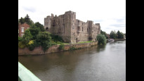
The Slow Ways route then follows the pavement by the road for 500m to the roundabout and crossing where you turn into Newark, again along pavements, and walk towards the town centre. This is understandable as using the crossing is the safer option but if you want to avoid a bit of road walking, on leaving the rugby club you can go straight across the A617 and go through fields into Newark, although there is also another road crossing. This short cut joins the Slow Ways route near the level crossing by Newark Castle station.
Go past the station, castle and parish church into the impressive market place.
-
Share your thoughts
StephenWalker
15 May 2022I walked this route from Southwell. The start is on quiet paths through the houses, and then onto field paths as far as Staythorpe. On the roads for a bit after that. Pavement all the way to the east side of Kelham Bridge. The bit alongside the A617 from Averham to Kelham is safe but noisy. From Kelham bridge we are fighting the landowner. The first field has potatoes in loose mounds separated by furrows. The path has not been reinstated. It was loose underfoot (being dry) but if it had been wet would be muddy. Just keep walking towards the spire of St Marys. The second field has both stiles behind the electric fence (both into and out of the field). You could walk round in the next field, but that is not the right of way. After the playing fields we are back on pavements. Good crossings of the busy roads, and into Newark. For me the pleasant country walking of half the route was spoiled by the A617 and the inconsiderate farmer.
-
Share your thoughts
Share your views about this route, give it a star rating, indicate whether it should be verified or not.
Include information that will be useful to others considering to walk or wheel it.
You can add up to 15 photos.
There are no other routes for Southwell (Notts) — Newark-on-Trent
If you know a better way, then please let us know.
Review this better route and help establish a trusted network of walking routes.
Suggest a better route if it better meets our methodology.
Share your thoughts