Sixpenny Handley — Salisbury
Sixsal one

Slow Way not verified yet. Verify Sixsal here.
Slow Way not verified yet. Verify Sixsal here.
By a Slow Ways Volunteer on 07 Apr 2021
Description
This is a Slow Ways route connecting Sixpenny Handley and Salisbury.
Know of a better route? Share it here.
This is a Slow Ways route connecting Sixpenny Handley and Salisbury.
Know of a better route? Share it here.
Status
This route has been reviewed by 1 person.
There are no issues flagged.
Photos for Sixsal one


Photos of this route will appear when they are added to a review. You can review this route here.
Information
Route status - Live
Reviews - 1
Average rating -
Is this route good enough? - Yes (1)
There are currently no problems reported with this route.
Downloads - 12
Surveys
What is this route like?
Surveys are submitted by fellow users of this website and show what you might expect from this Slow Ways route. Scroll down the page to read more detailed surveys.
| Grade 0U based on 0 surveys | Sign up or log in to survey this route. | ||
|---|---|---|---|
| Description | Note | ||
| Currently ungraded. Access grade U: Currently ungraded. |
Grading is based on average scores by surveyors. This slow way has 0 surveys. | ||
| Full grading description | |||
Only people who have completed our training can become Slow Ways surveyors and submit a survey. We do not vet contributors, so we cannot guarantee the quality or completeness of the surveys they complete. If you are dependent on the information being correct we recommend reading and comparing surveys before setting off.
Survey Photos

We are working to build-up a picture of what routes look like. To do that we are asking volunteers to survey routes so that we can communicate features, obstacles and challenges that may make a route desirable or not.
Slow Ways surveyors are asked to complete some basic online training, but they are not vetted. If you are dependent on the survey information being correct in order to complete a route, we recommend that you think critically about the information provided. You may also wish to wait until more than one survey has been completed.
Help people know more about this route by volunteering to submit a survey.
- Complete the survey training.
- Submit a survey for this route.
Geography information system (GIS) data
Total length
Maximum elevation
Minimum elevation
Start and end points
Sixpenny Handley
Grid Ref
ST9980517123
Lat / Lon
50.95353° / -2.00414°
Easting / Northing
399,805E / 117,123N
What3Words
client.report.bulge
Salisbury
Grid Ref
SU1449029970
Lat / Lon
51.06888° / -1.79457°
Easting / Northing
414,490E / 129,970N
What3Words
firm.ankle.often
Sixsal One's land is
| Sixpenny Handley | |
|---|---|
| Grid Ref | ST9980517123 |
| Lat / Lon | 50.95353° / -2.00414° |
| Easting / Northing | 399,805E / 117,123N |
| What3Words | client.report.bulge |
| Salisbury | |
|---|---|
| Grid Ref | SU1449029970 |
| Lat / Lon | 51.06888° / -1.79457° |
| Easting / Northing | 414,490E / 129,970N |
| What3Words | firm.ankle.often |
| Arable | 49.9% |
| Green urban | 2.4% |
| Pasture | 18.9% |
| Urban | 17.4% |
| Woods | 11.4% |
Data: Corine Land Cover (CLC) 2018
review
Charles312
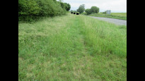
21 Jun 2023 (edited 08 Jul 2023)I thoroughly enjoyed this route, in particular the meadows across Martin Down, the sections under tree cover through Vernditch Chase and Knighton Wood, and the descent into the scenic River Ebble valley were all a pleasure to experience. It also "feels" very direct which helps this being one of the longer Slow Ways connecting Salisbury.
Because of the above and more, I've decided to give this route 4 stars and a 'Yes' recommendation, but it could arguably be given 3 and a 'Maybe' owing to the A354 crossings (details below). With a few adjustments it could have the makings of a 5 star.
Impressions:
The meadows through Martin Down were breathtaking, filled with wildflowers, scores of butterflies, and ground-nesting birds could be heard all around.
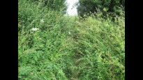
Not strictly owing to Slow Ways route, but a closed footpath along Vernditch Chase led me onto a serendipitous detour through the heart of the woods, beginning with a fantastical outcrop of stones, exposed roots and other woodland debris. Despite having to map the diversion and going back on myself I feel richer for it.
Another highlight was the comfortable, perfectly straight footpath (owing to the old Roman road it follows) under tree cover on the approach to and going through Knighton Wood. For a spell I almost forgot that I was reviewing and photo surveying a Slow Ways route at all.
Not long after is a large section across open farmland where the RoWs have been helpfully mowed to stubble making them effortless to follow, which allowed me to focus on the outstanding views of Croucheston Down.
The only potential downsides were the crossings of the A354, and the route between Coombe Bissett and Harnham feeling very much like an "A to B", though Salisbury Cathedral coming into full view on Old Shaftsbury Drove alleviated this somewhat.
This was soon forgotten however as the urban section of this route beginning in Harnham follows one of the best trails the city has to offer. After a fairly long walk the flat, majority traffic-free paths and conveniently placed pedestrian crossings from the outskirts in Harnham straight through to the meeting place, enriched with the Harnham watermeadows in between, felt more akin to a relaxed evening stroll to finish off the route.
Observations:
1) The footpath leaving Martin Down meadows into and along the edge of Verdict Chase woods is currently CLOSED owing to dangerous trees at the time of writing (Jun 23) so I had to detour through Verdict Chase woods proper. I have included details of this diversion in the supplemental photo survey I completed for this route.
2) This route includes up to four crossings of the busy A354, two-a-piece owing to how the roads are arranged: the first two after Woodyates and the second two at Coombe Bissett. For the Woodyates the national speed limit (60mph) applies but the visibility is good in both directions and there are frequent large gaps in traffic to facilitate safe crossing (tested 11am on a weekday for this review). For the Coombe Bissett it's a 30mph zone that pedestrians regularly traverse, but care should still be taken. For more detail and advice on safely navigating the crossings please refer to the photo survey I submitted.
a) It should be possible to avoid the Woodyates crossing altogether taking the road northward instead of descending into the village, joining the footpath toward Chettle Head Copse, then following the RoW back down to Vernditch Chase woods. I haven't tested this diversion however, and it's not particularly direct.
b) To avoid the Coombe Bissett crossing an alternative might be to bypass the village altogether, instead heading north after arriving at Stratford Tony, crossing Stratford Tony Road, then joining the RoW (course of Roman road) until it intersects with Drove Lane and back on the Slow Ways route. I have used these paths before, and I don't believe they are out of keeping with the rest of the route.
Photographs:
Passing a manor estate after leaving Sixpenny Handley
Butterfly on Martin Down
Landscape view from Martin Down
Fungi from the footpath approaching Knighton Wood
View of Croucheston Down
First glimpse of Salisbury Cathedral's spire approaching Faulston Hole
Landscape approaching Faulston Hole
Landscape before descending into the River Ebble valley
Full view of Salisbury Cathedral from Old Shaftsbury Drove
Wading bird resting in Harnham Watermeadows.
Share your views about this route, give it a star rating, indicate whether it should be verified or not.
Include information that will be useful to others considering to walk or wheel it.
You can add up to 15 photos.
There are no other routes for Sixpenny Handley — Salisbury
If you know a better way, then please let us know.
Review this better route and help establish a trusted network of walking routes.
Suggest a better route if it better meets our methodology.
Share your thoughts