Shepton Mallet — Frome
Shefro one

Slow Way not verified yet. Verify Shefro here.
Slow Way not verified yet. Verify Shefro here.
By a Slow Ways Volunteer on 07 Apr 2021
Description
This is a Slow Ways route connecting Shepton Mallet and Frome.
Know of a better route? Share it here.
This is a Slow Ways route connecting Shepton Mallet and Frome.
Know of a better route? Share it here.
Status
This route has been reviewed by 1 person.
There are no issues flagged.
Photos for Shefro one


Photos of this route will appear when they are added to a review. You can review this route here.
Information
Route status - Live
Reviews - 1
Average rating -
Is this route good enough? - Yes (1)
There are currently no problems reported with this route.
Downloads - 8
Surveys
We are working to build-up a picture of what routes look like. To do that we are asking volunteers to survey routes so that we can communicate features, obstacles and challenges that may make a route desirable or not.
Slow Ways surveyors are asked to complete some basic online training, but they are not vetted. If you are dependent on the survey information being correct in order to complete a route, we recommend that you think critically about the information provided. You may also wish to wait until more than one survey has been completed.
Help people know more about this route by volunteering to submit a survey.
- Complete the survey training.
- Submit a survey for this route.
Geography information system (GIS) data
Total length
Maximum elevation
Minimum elevation
Start and end points
Shepton Mallet
Grid Ref
ST6188943653
Lat / Lon
51.19081° / -2.54673°
Easting / Northing
361,889E / 143,653N
What3Words
compress.scrambles.frost
Frome
Grid Ref
ST7764948039
Lat / Lon
51.23109° / -2.32149°
Easting / Northing
377,649E / 148,039N
What3Words
gangs.mull.truth
Shefro One's land is
| Shepton Mallet | |
|---|---|
| Grid Ref | ST6188943653 |
| Lat / Lon | 51.19081° / -2.54673° |
| Easting / Northing | 361,889E / 143,653N |
| What3Words | compress.scrambles.frost |
| Frome | |
|---|---|
| Grid Ref | ST7764948039 |
| Lat / Lon | 51.23109° / -2.32149° |
| Easting / Northing | 377,649E / 148,039N |
| What3Words | gangs.mull.truth |
| Arable | 16.2% |
| Other | 0.8% |
| Pasture | 63.7% |
| Urban | 10.3% |
| Woods | 8.9% |
Data: Corine Land Cover (CLC) 2018
review
Panifex
23 Oct 2022This is a fantastic walk, mostly along the well used and well waymarked East Mendip Way, diverting to visit Leigh-Upon-Mendip at the half-way point.
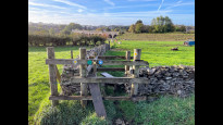
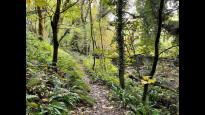
The route is mostly on footpaths through fields and woodlands. It is only suitable for walkers - there are many stiles and gates, and it was very muddy in places. This was especially noticeable in the woods near Whatley Quarry, where the path and the stream became indistinguishable in places. Waterproof boots definitely recommended!
There are a couple of road crossings where care is required - they are fast and busy, but visibility is good.
The route out of Shepton is possibly a little confusing for anyone not acquainted with the town - but it is well mapped, so no problems if you follow the route. It takes you down some small alleyways near to the prison.
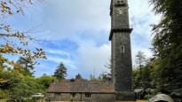
The diversion from the East Mendip Way to Leigh upon Mendip is necessary to make this route compliant to the Slow Ways methodology (and the church and pub there are well worth a visit - and it is possible to make yourself a cup of tea in the church for a small donation). However, if you don't need the rest then cutting off that corner and continuing on the East Mendip Way would be more direct. Note, there used to be a really good tea room at Cranmore Tower - but I didn't visit on this occasion, and am not sure if it is still open. The tower itself is well worth a visit if it's open.
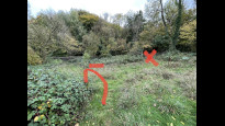
I mostly found this very easy to navigate, only occasionally having to check the map. There was, however, one slightly difficult section. At the bottom of Raiford Hill (ST 7260 4739). The problem is not with the .gpx file as uploaded (although a bit of extra accuracy at this point wouldn't hurt) rather with the way the footpaths are mapped. The trick is to NOT join the road - even though the sign there has an old East Mendip Way sticker on it - but rather follow the path round to the left. There is a finger post to show the way, but it was entirely hidden by brambles. I walked this route from Shepton Mallet to Frome - I tried this small section from the opposite direction and it was very clear and would not cause any difficulty that way. Just something to be aware of.
Overall, a recommended route for walkers.
Share your views about this route, give it a star rating, indicate whether it should be verified or not.
Include information that will be useful to others considering to walk or wheel it.
You can add up to 15 photos.
There are no other routes for Shepton Mallet — Frome
If you know a better way, then please let us know.
Review this better route and help establish a trusted network of walking routes.
Suggest a better route if it better meets our methodology.
Share your thoughts