Portishead — Aust
Poraus three

Slow Way not verified yet. Verify Poraus here.
Slow Way not verified yet. Verify Poraus here.
By philtromb on 17 Dec 2023
Description
I have created this route is an inland alternative to Poraus one.
The southern section, up to the Avon Bridge, is identical to Poraus one. The northern section is routed via Blaise Castle and the Severn Vale, using the Community Forest Path, rather than the Severn Way
I have created this route is an inland alternative to Poraus one.
The southern section, up to the Avon Bridge, is identical to Poraus one. The northern section is routed via Blaise Castle and the Severn Vale, using the Community Forest Path, rather than the Severn Way
Status
This route has been reviewed by 1 person.
There are no issues flagged.
Photos for Poraus three


Photos of this route will appear when they are added to a review. You can review this route here.
Information
Route status - Live
Reviews - 1
Average rating -
Is this route good enough? - Yes (1)
There are currently no problems reported with this route.
Downloads - 1
Surveys
We are working to build-up a picture of what routes look like. To do that we are asking volunteers to survey routes so that we can communicate features, obstacles and challenges that may make a route desirable or not.
Slow Ways surveyors are asked to complete some basic online training, but they are not vetted. If you are dependent on the survey information being correct in order to complete a route, we recommend that you think critically about the information provided. You may also wish to wait until more than one survey has been completed.
Help people know more about this route by volunteering to submit a survey.
- Complete the survey training.
- Submit a survey for this route.
Geography information system (GIS) data
Total length
Maximum elevation
Minimum elevation
Start and end points
Portishead
Grid Ref
ST4674676449
Lat / Lon
51.48447° / -2.76832°
Easting / Northing
346,746E / 176,449N
What3Words
riverside.whispers.crusted
Aust
Grid Ref
Lat / Lon
51.59831° / -2.61579°
Easting / Northing
0E / 0N
What3Words
again.clotting.mulled
| Portishead | |
|---|---|
| Grid Ref | ST4674676449 |
| Lat / Lon | 51.48447° / -2.76832° |
| Easting / Northing | 346,746E / 176,449N |
| What3Words | riverside.whispers.crusted |
| Aust | |
|---|---|
| Grid Ref | |
| Lat / Lon | 51.59831° / -2.61579° |
| Easting / Northing | 0E / 0N |
| What3Words | again.clotting.mulled |
Sorry Land Cover data is not currently available for this route. Please check back later.
review
Mockymock
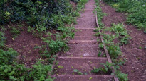
20 Apr 2024 (edited 01 May 2024)This is an excellent alternative routing of this long Slow Way while the more obvious route along the River Severn continues to be blocked by major flood works. It isn't any further either, but is more up and down. The only reason I don't give it five stars is that it takes an unnecessarily convoluted route through Henbury and the Blaise Castle Estate, which requires more walking effort when there are more direct and easier options. Otherwise an interesting and often lovely walk, although you will almost always hear distant or less distant sounds of traffic rumbling around on the many major roads in this busy area.
Note that the section across the Severn Vale from Easter Compton to Aust will be a struggle when the ground is saturated (as it has been all winter and early Spring 2023/4) unless you don't mind very soggy conditions and a bit of wading through standing water. It was, however, good enough underfoot in mid April after a couple of weeks of reasonably dry weather, so likely fine for most of the year.
I describe the route in the Aust to Portishead direction.
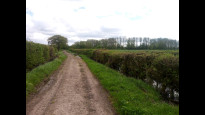
It heads out on a green lane to take a path through newly created wetlands that are part of extensive flood defence works going on in the area (Ignore all the big white signs you may still encounter warning you about footpath closures and alterations on this walk. They are no longer relevant to this route).
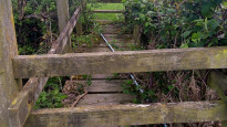
From there it is footpaths through pastures and long stretches of track across the Severn Vale to Easter Compton. This area still has old-school, and now rather worn wooden footbridges and stiles, often with a few brambles snaking over them. Signage is also a tad patchy. At Bilsham Farm stay in the field east of the farm buildings as there is no footpath through the yard as the OS map suggests. Also the track going on from Holm Farm can hold water in the winter, but only a bit of edging round the biggest puddles was required today.
Eventually, after crossing over the M4, under the mainline railway at Pilning, and the access road to The Wave (an artificial surfing lake), the route arrives at the village of Easter Compton and picks up the waymarked Community Forest Path. Note that the plot going out of Easter Compton goes through the car park of the village hall rather than down the marked footpath on the other side of it for some reason, but this is a minor oddity.
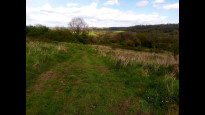
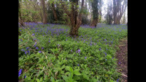
Onwards you go through fields and a churchyard and across a road to head up the interestingly-named Spaniorum Hill (novel after many miles of walking on the flat) through some scrubby fields, some of which are open access. As you climb, big views open out across the Severn Vale and over to Wales. On the flat top of the hill the path edges round more grassy fields by some woods which had carpets of bluebells in places at this time of year. Conditions underfoot were sometimes a little soft.
Then it is motorway-crossing number two using an access road bridge. Note that the plot of the slow way is correct on the approach. The footpath on the OS map is impassable.
There was a bit of fly tipping beside the road winding on downhill beyond and housebuilding was in muddy progress on some adjacent land, but the woods to the west of the road were still beautiful. At the bottom the path heads in through some pony paddocks (the slow way plot is again the correct way here) before crossing the railway into the edge of Bristol at Henbury.
Here I would recommend skipping the nice but fiddly detour round the back of the school on the Community Forest path that the the slow way plot follows, and just go straight along the suburban B-road. It is not far and much quicker.
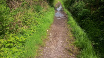
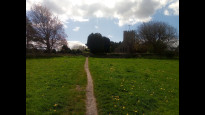
There follows a few miles of walking through the Blaise Castle estate and along Kingsweston Down to Shirehampton. This is all lovely open access parkland, populated with dog-walkers and many families at weekends.
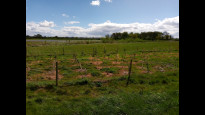
Here the Slow Way again takes an unnecessarily long way round on the Community Forest Path, routing from Blaise castle museum down into the wooded, limestone valley before climbing up a steep, stony path through to get back out again. It is a beautiful scenic walk, but it is so much more direct and so much less less effort to head straight across the grass in a west-southwesterly direction from the museum and pick up the plotted route again at Echo Gate (I have uploaded a photo of this route option on a standard map so you can get the idea).
There follows a short climb to Kingsweston Hill and a long flat walk along a big open ride between woodlands which, after a while, funnels gently downhill into a track down to Shirehampton. At the bottom you have to make an annoying jink south to cross the road because the footbridge was condemned. Hopefully something will reopen soon: works appear to be going on at the moment.
Then, once again, the slow way takes the longer way round via Kingsweston House when you could you cut off a corner and go straight on through the woods. However, this short diversion is more worth it for the approach to the grand house and the contrasting views over the modern Avonmouth industrial area lying to the north once you reach it and round the corner.
The way onward is along the narrowing limestone ridge (there are paths on either side which eventually combine into one so it doesn't matter which you use) before dropping down a set of wooden steps into the housing estates at Shirehampton.
It is all change now as the the Slow Way picks up an off-road cycle/footpath over the high arc of the M5 motorway bridge over the River Avon (incredibly loud and fume-ridden but kind of thrilling, with a view) and ploughs on through the boisterous weed-fringed edgelands around the back of Avonmouth Docks and mammoth carparks full of recently imported vehicles. After a couple of miles you arrive at the Sheepway, where there is a bit of a walk along the road, some of which doesn't have a footway. This was once the main thoroughfare to Portishead but has long since been superseded by bigger road, so is now pretty quiet and rural, although still used by local buses, so keep an eye.
After a few hundred metres, you turn down Wharf Lane, which then becomes a hedge-lined track through Portbury Wharf wetland reserve (which has bird hides you can visit) before you approach the most modern part of Portishead along the sea front, which looks out across some saltmarsh and the swirling Severn Estuary to Wales. The way into town is along a path beside a little straight canal, although if you follow the England coast path signs to cross the lock a little further west instead, you could equally well walk into town along the west side of the modern marina, where there is more to see.
There is no public transport to Aust at all (you'd have to go several miles across the old Severn Bridge into Chepstow for the nearest option) but there is a good pub. You can pick up a bus at Easter Compton, which I think also has a pub. Obviously there are plenty of facilities and transport options once you get into the suburbs of Bristol.
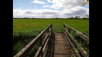
There will be certainly be livestock grazing on the Severn Vale in summer, including cows. My rather muddy photos are all from the part of the walk between Aust and Shirehampton.
Share your views about this route, give it a star rating, indicate whether it should be verified or not.
Include information that will be useful to others considering to walk or wheel it.
You can add up to 15 photos.
Other Routes for Portishead—Aust See all Slow Ways
Review this better route and help establish a trusted network of walking routes.
Suggest a better route if it better meets our methodology.
Share your thoughts