Perth — Blairgowrie
Perbla one

Slow Way not verified yet. Verify Perbla here.
Slow Way not verified yet. Verify Perbla here.
By a Slow Ways Volunteer on 07 Apr 2021
Description
This is a Slow Ways route connecting Perth and Blairgowrie.
Know of a better route? Share it here.
This is a Slow Ways route connecting Perth and Blairgowrie.
Know of a better route? Share it here.
Status
This route has been reviewed by 1 person.
There are no issues flagged.
Photos for Perbla one


Photos of this route will appear when they are added to a review. You can review this route here.
Information
Route status - Live
Reviews - 1
Average rating -
Is this route good enough? - Yes (1)
There are currently no problems reported with this route.
Downloads - 4
Surveys
We are working to build-up a picture of what routes look like. To do that we are asking volunteers to survey routes so that we can communicate features, obstacles and challenges that may make a route desirable or not.
Slow Ways surveyors are asked to complete some basic online training, but they are not vetted. If you are dependent on the survey information being correct in order to complete a route, we recommend that you think critically about the information provided. You may also wish to wait until more than one survey has been completed.
Help people know more about this route by volunteering to submit a survey.
- Complete the survey training.
- Submit a survey for this route.
Geography information system (GIS) data
Total length
Maximum elevation
Minimum elevation
Start and end points
Perth
Grid Ref
NO1164323744
Lat / Lon
56.39765° / -3.43305°
Easting / Northing
311,643E / 723,744N
What3Words
grew.acting.solved
Blairgowrie
Grid Ref
NO1801045181
Lat / Lon
56.59133° / -3.33669°
Easting / Northing
318,010E / 745,181N
What3Words
founders.awakening.alarming
Perbla One's land is
| Perth | |
|---|---|
| Grid Ref | NO1164323744 |
| Lat / Lon | 56.39765° / -3.43305° |
| Easting / Northing | 311,643E / 723,744N |
| What3Words | grew.acting.solved |
| Blairgowrie | |
|---|---|
| Grid Ref | NO1801045181 |
| Lat / Lon | 56.59133° / -3.33669° |
| Easting / Northing | 318,010E / 745,181N |
| What3Words | founders.awakening.alarming |
| Arable | 41.1% |
| Green urban | 2.0% |
| Pasture | 5.8% |
| Urban | 18.0% |
| Water | 13.7% |
| Woods | 19.4% |
Data: Corine Land Cover (CLC) 2018
review
F Berry
02 May 2022This long route is interesting and varied. I am unable to give it 5 stars, due to the short section just north of Luncarty where there is only a faint trace of a path, and as it is along a field edge it might be quite difficult to walk when crops are growing. However there are plans for an off road route between Luncarty and Stanley, so if these come to fruition the route would become much easier to use. The route as a whole would only be usable by walkers, due to this constraint, also there are steps up to Stanley, and other parts of the route are on uneven, rough paths with tree roots. However parts of the route would be usable by wheelchairs especially from Perth north to the River Almond, and the paths and farm tracks closer to Blairgowrie should be usable by off road wheelers.
PerBla is more or less correctly mapped. The central portion (Luncarty and Stanley) is served by frequent buses to Perth. There are also shops in Luncarty and Stanley, and accommodation options in the Stanley/Ballathie/Meikleour area. Most of the route is signposted or waymarked.
The route heads north from Perth City Centre on a very pleasant paved cycle route along the North Inch, beside the River Tay. There are also trodden paths closer to the river. On reaching the River Almond there are underpasses beneath the A9 road, and the Perth-Inverness railway line. The route crosses the River Almond on the former A9 bridge with little traffic. North of the River Almond, PerBla goes through woodland, then northwards beside the River Tay. It is quite scenic, but on a trodden path with tree roots and undulations. It must be noted that the Cross Tay link road is about to be constructed, this will have implications for the riverside path, but as it is a right of way and core path an alternative route should be provided.
Three (to date) Slowways pass through Luncarty, each using slightly different routes through the streets. PerBla continues along the River Tay for as long as possible, then heads inland to pass the local shop. A brief distance along the pavement beside the B9099 the route heads towards a rather dilapidated bridge over the Ordie Burn at Milton of Luncarty (photo). It goes all the way round a large field, to the confluence of the Ordie Burn with the River Tay, then northwards beside the Tay on a faint trodden path. There is a fence to cross, and the remains of a stile (photo). This is the most challenging part of the route, about 1km long, but the alternative along the busy B9099 which has no pavement is not to be recommended. An active travel route between Luncarty and Stanley is being considered, but a route has yet to be agreed.
Northwards from East Nether Benchil the route is delightful, following a fisherman's path between an old mill lade and the River Tay. Approaching Stanley there is a lengthy flight of timber steps, then a walk into the village along a pavement. The village store is on Percy Street, which is parallel to King Street (along which PerBla runs).
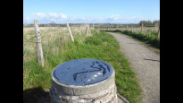
Leaving the village on the Shiel Hill path the top of the hill gives good views all round. The route along to Ballathie is waymarked, but fairly featureless, following a field edge (photo) then the line of a former railway. Near Ballathie House Hotel (possible refreshments or accommodation), at a decaying building, PerBla leaves the old railway and takes a trodden path along the edge of a wood to West Woodend (photo of northern end of path). A short stretch of lane takes PerBla to Kinclaven Wood, now managed by the Woodland Trust. PerBla is not quite accurately mapped in the wood; there are many paths through the wood, which is known for its bluebells in May. It is worth taking a small diversion, on grass paths, to visit the memorial cairn to the east, which gives extensive views.
From Kinclaven, following a busy minor road for 1.5km over Kinclaven Bridge, is not too pleasant, but there are verges above the level of the road into which one can retreat. At Meikleour lodge PerBla takes an estate road behind Meikelour beech hedge. It is worth taking a short detour to view the front of the hedge, the longest hedge in Britain and the highest of its kind in the world (100ft/30m). Nearing the gateway to Meikleour House there's a new short gravelled short cut. In the hamlet of Meikleour the route passes the Meikleour Arms Hotel, offering possible refreshments and accommodation. Northwards from Meikleour the route is again waymarked, passing through North Wood, then using a zigzag of farm tracks to reach the outskirts of Blairgowrie near White Loch (photo of beaver damage). Once in Blairgowrie the route mainly follows paths, then pavements, and avoids main roads until the final stretch into the centre.
Share your views about this route, give it a star rating, indicate whether it should be verified or not.
Include information that will be useful to others considering to walk or wheel it.
You can add up to 15 photos.
There are no other routes for Perth — Blairgowrie
If you know a better way, then please let us know.
Review this better route and help establish a trusted network of walking routes.
Suggest a better route if it better meets our methodology.
Share your thoughts