Description
Between Cowbridge and Llangan, this route is the same as Pencow2. The road route near Pencoed is also the same. Instead of going via Treoes, it takes a more direct route through St Mary Hill
Between Cowbridge and Llangan, this route is the same as Pencow2. The road route near Pencoed is also the same. Instead of going via Treoes, it takes a more direct route through St Mary Hill
Status
This route has been reviewed by 4 people.
This route has been flagged (1 times) for reasons relating to safety.
Photos for Pencow three


Photos of this route will appear when they are added to a review. You can review this route here.
Information
")
Route status - Live
Reviews - 4
Average rating -
Is this route good enough? - Yes (3) No (1)
Problems reported - Safety (1)
Downloads - 5
Surveys
What is this route like?
Surveys are submitted by fellow users of this website and show what you might expect from this Slow Ways route. Scroll down the page to read more detailed surveys.
| Grade 3X based on 1 surveys | Sign up or log in to survey this route. | ||
|---|---|---|---|
| Description | Note | ||
| Grade 3: Route includes rough surfaces that may include small boulders, potholes, shallow ruts, loose gravel, short muddy sections. Access grade X: At least one stile, flight of steps or other obstacle that is highly likely to block access for wheelchair and scooter users. |
Grading is based on average scores by surveyors. This slow way has 1 surveys. | ||
| Full grading description | |||
Only people who have completed our training can become Slow Ways surveyors and submit a survey. We do not vet contributors, so we cannot guarantee the quality or completeness of the surveys they complete. If you are dependent on the information being correct we recommend reading and comparing surveys before setting off.
Survey Photos
Facilities
Facilities in the middle third of this route.
Challenges
Potential challenges reported on this route. Some challenges are seasonal.
Obstacles
Obstacles on this route.
Accessibility
Is this route step and stile free?
Measurements
Surveyors were asked to measure the narrowest and steepest parts of paths.
The narrowest part of the path is 50.0cm (1)
The steepest uphill gradient walking East 55.0% (1)
The steepest uphill gradient walking West 70.0% (1)
The steepest camber gradient across the path 2.0% (1)
How clear is the waymarking on the route: Unclear in places (1)
Successfully completed
We asked route surveyors "Have you successfully completed this route with any of the following? If so, would you recommend it to someone with the same requirements?". Here is how they replied.
Recommended by an expert
We asked route surveyors "Are you a trained access professional, officer or expert? If so, is this route suitable for someone travelling with any of the following?" Here is how they replied.
Terrain
We asked route surveyors to estimate how much of the route goes through different kinds of terrain.
40.0% of the route is on roads (1)
25.0% of the route is lit at night (1)
30.0% of the route is paved (1)
45.0% of the route is muddy (1)
20.0% of the route is over rough ground (1)
20.0% of the route is through long grass (1)
Report a problem with this data
1 surveys
Information from verified surveys.
Geography information system (GIS) data
Total length
Maximum elevation
Minimum elevation
Start and end points
Pencoed
Grid Ref
SS9594881629
Lat / Lon
51.52396° / -3.50122°
Easting / Northing
295,948E / 181,629N
What3Words
hazelnuts.lush.nature
Cowbridge
Grid Ref
SS9955274639
Lat / Lon
51.46178° / -3.44730°
Easting / Northing
299,552E / 174,639N
What3Words
decisions.obliging.winemaker
| Pencoed | |
|---|---|
| Grid Ref | SS9594881629 |
| Lat / Lon | 51.52396° / -3.50122° |
| Easting / Northing | 295,948E / 181,629N |
| What3Words | hazelnuts.lush.nature |
| Cowbridge | |
|---|---|
| Grid Ref | SS9955274639 |
| Lat / Lon | 51.46178° / -3.44730° |
| Easting / Northing | 299,552E / 174,639N |
| What3Words | decisions.obliging.winemaker |
Sorry Land Cover data is not currently available for this route. Please check back later.
reviews
Paul Chilcott
20 Feb 2024February 2024. Direction: Cowbridge to Pencoed.
A good Vale walk, mostly through fields and lanes. My walk was on the first dry day after a few days of rain, so the fields were sodden and there were some minor flooding of the lanes, especially around the Llangan area. I was wearing walking boots and managed to find a way through without getting my feet wet. Throughout the walk, there was a variety of gates, stone styles and wooden styles. It was generally very well signposted and starts off following the Great Glamorgan Way, but also crosses the Valeways network for a while, but there were just a couple of sections that were not well signed. After leaving the church at Llangan, there are no signs through the fields to St. Mary Hill, but head for the gate at the top of the field on the edge of the village, which the hidden style is next to. The other easy to miss turning was the track at the top of the woods just before Pant y gog and the descent through the woods down towards Pencoed. Take care with the steps leaving the main road by the Cowbridge by-pass - very steep!
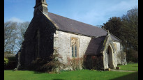
Photo 1 - Penllyn Castle
Photo 2 - Penllyn church
Photo 3 - View towards Bridgend from just outside Penllyn village
Photo 4 - View towards Pencoed from after St. Mary Hill.
Sftuck
12 Sep 2023Walked from Cowbridge to Pencoed. This is a nice rural walk for the majority, let down by the road crossing at the end. It didn't feel at all safe to cross from this direction as the oncoming traffic is coming from around a bend with poor visibility and it seemed very busy. Perhaps it's better crossing the other way but I definitely can't recommend it. The rest of the walk was great.
-
Share your thoughts
Stuart Bain
27 Nov 2022Walked from Pencoed to Cowbridge. As the previous reviewer said once you’re out of Pencoed and over the A473 the walk starts properly.
The first section is fairly easy road and path walking with three wooden stiles as you climb up to St Mary’s Hill. Once you hit the top (look out for the trig point just off route) it descends through a farm and numerous gates to the road entering into the hamlet of St Mary Hill.
The next stretch is really pleasant walking between hedgerows through the countryside. Unfortunately one section was completely impassable due to flooding just as you approach Llangan. I suspect this is always flooded judging the depth and lack of vegetation.
There is a section a road walking as you got though Llangan but the village is beautiful so worth doing. There is a pub in the village called the Red Fox but it looked permanently closed when I passed it.
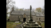
The rights of way aren’t clear in the next section as you pass St John the Evangelist church at the end of the village. Don’t be put off by large ‘private’ signs as you approach. The right of way goes off to the right and it’s not that obvious.
Once on the fields the route is fairly clear, so follow the path descending into the Penllyn estate. Forage is a fantastic cafe to stop at if you want a break. It opened a few years back and it’s quickly established itself as a fantastic venue.
As you pass the lodges be really careful with the horrendous slippery steps going down to the road.
Overall fantastic walk despite the murky conditions. A few wonky stiles at the start of the walk and the steps descending into Cowbridge must be navigated with care.
The last photo goes an idea of pace. The slower sections are either gradient or landmarks worth looking at.
One I would definitely do again!.
-
Share your thoughts
MaddyT
12 Mar 2022Walking from Pencoed, this is a scenic route once south of the A473: woods, fields, lanes, mostly well-marked footpaths, and a pub in Penllyn. Things to note:
1) Just south of Pencoed, the path through the wood near Tan-y-lan Farm is clearly marked at the bottom but not at the top; if walking towards Pencoed, look out for it as you approach the wood. If you miss it, you can take the zigzag route that skirts Tan-y-lan.
2) Leaving Penllyn towards Cowbridge, go past the church and along the driveway until you see two signs saying there is no right of way; look for the footpath marker on the right, through the fence and across the fields.
3) There are some very steep stone steps linking Cowbridge Cabins with Gibbet Hill (A4222); care is needed.
-
Share your thoughts
Share your views about this route, give it a star rating, indicate whether it should be verified or not.
Include information that will be useful to others considering to walk or wheel it.
You can add up to 15 photos.
Other Routes for Pencoed—Cowbridge See all Slow Ways
Review this better route and help establish a trusted network of walking routes.
Suggest a better route if it better meets our methodology.
Share your thoughts