Lyme Regis — Bridport
Lymbri one

Slow Way not verified yet. Verify Lymbri here.
Slow Way not verified yet. Verify Lymbri here.
By a Slow Ways Volunteer on 07 Apr 2021
Description
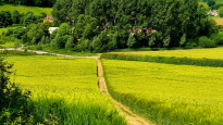
This is a Slow Ways route connecting Lyme Regis and Bridport.
Know of a better route? Share it here.
This is a Slow Ways route connecting Lyme Regis and Bridport.
Know of a better route? Share it here.
Status
This route has been reviewed by 2 people.
This route has been flagged (1 times) for reasons relating to access.
Photos for Lymbri one


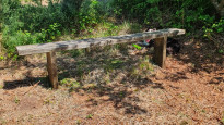


Photos of this route will appear when they are added to a review. You can review this route here.
Information
Route status - Live
Reviews - 2
Average rating -
Is this route good enough? - Yes (1) Maybe (1)
Problems reported - Access (1)
Downloads - 16
Surveys
What is this route like?
Surveys are submitted by fellow users of this website and show what you might expect from this Slow Ways route. Scroll down the page to read more detailed surveys.
| Grade 4X based on 1 surveys | Sign up or log in to survey this route. | ||
|---|---|---|---|
| Description | Note | ||
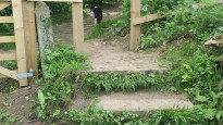
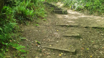
| Grade 4: Route includes very rough surfaces including deep ruts, steep loose gravel, unmade paths and deep muddy sections. Wheelchairs may experience traction/wheel spin issues. Access grade X: At least one stile, flight of steps or other obstacle that is highly likely to block access for wheelchair and scooter users. |
Grading is based on average scores by surveyors. This slow way has 1 surveys. | ||
| Full grading description | |||
Only people who have completed our training can become Slow Ways surveyors and submit a survey. We do not vet contributors, so we cannot guarantee the quality or completeness of the surveys they complete. If you are dependent on the information being correct we recommend reading and comparing surveys before setting off.
Survey Photos

Facilities
Facilities in the middle third of this route.
Challenges
Potential challenges reported on this route. Some challenges are seasonal.
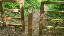
Obstacles
Obstacles on this route.
Accessibility
Is this route step and stile free?
Measurements
Surveyors were asked to measure the narrowest and steepest parts of paths.
Narrowest part of path: no data
The steepest uphill gradient East: no data
The steepest uphill gradient West: no data
The steepest camber: no data
How clear is the waymarking on the route: Unclear in places (1)
Successfully completed
We asked route surveyors "Have you successfully completed this route with any of the following? If so, would you recommend it to someone with the same requirements?". Here is how they replied.
Recommended by an expert
We asked route surveyors "Are you a trained access professional, officer or expert? If so, is this route suitable for someone travelling with any of the following?" Here is how they replied.
Terrain
We asked route surveyors to estimate how much of the route goes through different kinds of terrain.
There is no data on how much of this route is on roads
There is no data on how much of this route is lit at night
Thereis no data on amount of route paved
There is no data on muddiness
There is no data on rough ground
There is no data on long grass
Report a problem with this data
1 surveys
Information from verified surveys.
Geography information system (GIS) data
Total length
Maximum elevation
Minimum elevation
Start and end points
Lyme Regis
Grid Ref
SY3421192062
Lat / Lon
50.72443° / -2.93341°
Easting / Northing
334,211E / 92,062N
What3Words
flagged.jacuzzi.detonated
Bridport
Grid Ref
SY4659092902
Lat / Lon
50.73325° / -2.75817°
Easting / Northing
346,590E / 92,902N
What3Words
because.treatment.retain
Lymbri One's land is
| Lyme Regis | |
|---|---|
| Grid Ref | SY3421192062 |
| Lat / Lon | 50.72443° / -2.93341° |
| Easting / Northing | 334,211E / 92,062N |
| What3Words | flagged.jacuzzi.detonated |
| Bridport | |
|---|---|
| Grid Ref | SY4659092902 |
| Lat / Lon | 50.73325° / -2.75817° |
| Easting / Northing | 346,590E / 92,902N |
| What3Words | because.treatment.retain |
| Arable | 32.5% |
| Other agricultural land | 3.8% |
| Pasture | 30.6% |
| Urban | 27.9% |
| Woods | 5.2% |
Data: Corine Land Cover (CLC) 2018
reviews
Pete
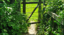
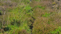
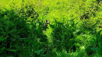
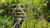
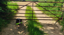
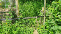
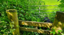
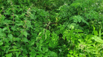
30 Sep 2022We we’re disappointed with this route. As with the previous reviewer, there are problems still existing with this route. Paths are overgrown, difficult to find, lack of footpath markers , paths not reinstated by farmers.and finally the last stage from Charmouth to Lyme Regis was along busy roads. Fine views are available from time to time but overall a poor route.
Helen Gough
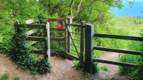
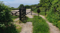
02 Jun 2022 (edited 13 Jun 2022)I walked from Bridport to Lyme Regis. This is a great walk, but I dropped it to 4 stars just because there are some short sections where the paths are not maintained, so are difficult to walk on, and in some cases they are hard to find. The worst bits are around Crepe Farm, and from Hounsells Cross up to Morecombelake. My tip is to do this walk with 4 or 5 people, then when you get to those areas, hang back to tie a shoelace or something, and let your friends tramp the vegetation down while you glide along like a queen (or king).
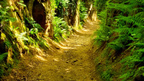
Hell Lane is very interesting as there are many carvings in the rock, lots of names and faces, but also some art. However, the western section has a small shallow stream running through it, so is slippery, muddy and rough.
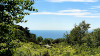
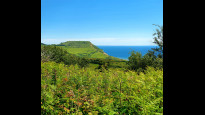
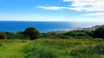
Hardown Hill has fantastic views and is also an SSSI. Then Stonebarrow has great sea views and also a cafe and shop. The walk down in to Lyme Regis is brilliant, the famous Cobb, the town and sea are all suddenly revealed and you head towards them.
There are loads of places to eat and drink in Bridport, Lyme and Charmouth. There is some road walking, but there is always a path, and where you walk on lanes, they are quiet.
Not a bad way to spend a few hours.
Update - Dorset County Council report that works are underway to clear the overgrown paths - you can now do the walk on your own!.
-
Share your thoughts
Share your views about this route, give it a star rating, indicate whether it should be verified or not.
Include information that will be useful to others considering to walk or wheel it.
You can add up to 15 photos.
There are no other routes for Lyme Regis — Bridport
If you know a better way, then please let us know.
Review this better route and help establish a trusted network of walking routes.
Suggest a better route if it better meets our methodology.
Share your thoughts