Lancaster — High Bentham
Lanchig three

Slow Way not verified yet. Verify Lanchig here.
Slow Way not verified yet. Verify Lanchig here.
By Mary Oz on 10 Jan 2023
Description
I designed and tried out another alternative, this time going over Whit Moor, with the aim of avoiding too many wet fields and busy roads, and the difficulties of the Lune Valley Ramble of my previous route
I designed and tried out another alternative, this time going over Whit Moor, with the aim of avoiding too many wet fields and busy roads, and the difficulties of the Lune Valley Ramble of my previous route
Status
This route has been reviewed by 1 person.
There are no issues flagged.
Photos for Lanchig three


Photos of this route will appear when they are added to a review. You can review this route here.
Information
Route status - Live
Reviews - 1
Average rating -
Is this route good enough? - Yes (1)
There are currently no problems reported with this route.
Downloads - 1
Surveys
What is this route like?
Surveys are submitted by fellow users of this website and show what you might expect from this Slow Ways route. Scroll down the page to read more detailed surveys.
| Grade 4X based on 1 surveys | Sign up or log in to survey this route. | ||
|---|---|---|---|
| Description | Note | ||
| Grade 4: Route includes very rough surfaces including deep ruts, steep loose gravel, unmade paths and deep muddy sections. Wheelchairs may experience traction/wheel spin issues. Access grade X: At least one stile, flight of steps or other obstacle that is highly likely to block access for wheelchair and scooter users. |
Grading is based on average scores by surveyors. This slow way has 1 surveys. | ||
| Full grading description | |||
Only people who have completed our training can become Slow Ways surveyors and submit a survey. We do not vet contributors, so we cannot guarantee the quality or completeness of the surveys they complete. If you are dependent on the information being correct we recommend reading and comparing surveys before setting off.
Survey Photos
Facilities
Facilities in the middle third of this route.
Challenges
Potential challenges reported on this route. Some challenges are seasonal.
Obstacles
Obstacles on this route.
Accessibility
Is this route step and stile free?
Measurements
Surveyors were asked to measure the narrowest and steepest parts of paths.
The narrowest part of the path is 20.0cm (1)
The steepest uphill gradient walking East 36.0% (1)
The steepest uphill gradient walking West 36.0% (1)
The steepest camber: no data
How clear is the waymarking on the route: Unclear in places (1)
Successfully completed
We asked route surveyors "Have you successfully completed this route with any of the following? If so, would you recommend it to someone with the same requirements?". Here is how they replied.
Recommended by an expert
We asked route surveyors "Are you a trained access professional, officer or expert? If so, is this route suitable for someone travelling with any of the following?" Here is how they replied.
Terrain
We asked route surveyors to estimate how much of the route goes through different kinds of terrain.
42.0% of the route is on roads (1)
30.0% of the route is lit at night (1)
72.0% of the route is paved (1)
25.0% of the route is muddy (1)
20.0% of the route is over rough ground (1)
20.0% of the route is through long grass (1)
Report a problem with this data
1 surveys
Information from verified surveys.
Geography information system (GIS) data
Total length
Maximum elevation
Minimum elevation
Start and end points
Lancaster
Grid Ref
SD4718261726
Lat / Lon
54.04879° / -2.80819°
Easting / Northing
347,182E / 461,726N
What3Words
lace.tight.agree
High Bentham
Grid Ref
SD6683269256
Lat / Lon
54.11811° / -2.50892°
Easting / Northing
366,832E / 469,256N
What3Words
prune.waxes.prowess
| Lancaster | |
|---|---|
| Grid Ref | SD4718261726 |
| Lat / Lon | 54.04879° / -2.80819° |
| Easting / Northing | 347,182E / 461,726N |
| What3Words | lace.tight.agree |
| High Bentham | |
|---|---|
| Grid Ref | SD6683269256 |
| Lat / Lon | 54.11811° / -2.50892° |
| Easting / Northing | 366,832E / 469,256N |
| What3Words | prune.waxes.prowess |
Sorry Land Cover data is not currently available for this route. Please check back later.
review
Mary Oz
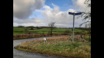
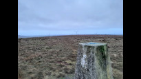
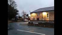
11 Jan 2023The main facilities on this 17 mile route are 5 miles from either end, at Wray (where there is an excellent licenced café - closed Mondays), and at Brookhouse/Caton (the Station pub in Caton is a slight detour from the cycle track). The middle 7 miles are pretty remote, with the trig point on Whit Moor being about half way.
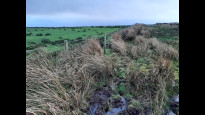
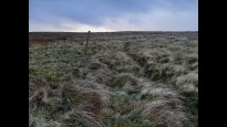
I walked from Bentham in winter. It didn’t rain until 3pm, but it had rained a lot in previous days, so I was glad that the fields and moorland made up a relatively small proportion of this long route, because they ranged from a bit muddy to quite wet peat bog. I think this would be a beautiful walk in a dry, sunny spell. The views from the trig point (and some distance before and after) are incredible, covering Lancaster, Morecambe Bay, the Lake District, the Yorkshire Dales including Ingleborough, and the Forest of Bowland.
There are lots of lovely old houses (17th century) in the vicinity of Wray. The views get steadily better as you climb the remote road out of Wray up lovely Roeburndale.
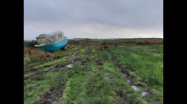
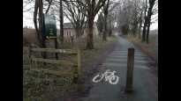
Once you reach the open access land after Thornbush Farm, lookout for the boat that looks as if it’s been there for decades. Go through both gates and follow the south east side of the fence. I made the mistake of only going through one gate and following the north west side of the fence, which was much boggier. I kept looking enviously at the other side of the fence, and realised, on reaching the gate at OS Grid Ref: SD 59224 64374, that it would have been the best route. From the gate, you can just see the tips of one of the wind turbines beyond the ridge. To the right of it, you can just make out a tall thick waymark post in the distant wall along the ridge. Head for this, there is a trodden track to follow, through the sedge and grass. If you have GPS, the plotted route is pretty close (at the time of writing!). There are also a few waymark posts.
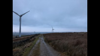
At the large waymark post there is a wooden kissing gate. Go through this and follow the track up to the trig point at the summit. The wind turbines become more prominent and they will be on your right as you climb. Give yourself a pat on the back, then head along another trodden track straight towards the turbines. There are grouse up here, possibly lots of other wildlife, which was sensibly hiding away from the strong westerly wind!
You soon reach a wall and go along the gravel and grass vehicle track here. For me, the turbines are awesome and felt like my friends who had guided my route. They were turning very fast!
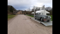
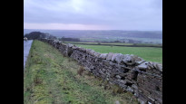
I easily passed a docile herd of Highland Cattle, and then reached the road and small car park. There are picnic tables here and an information board about one of the first commercial windfarms in the UK. I felt some relief reaching the road, as the sky had darkened quite a bit, and it was now raining straight into my face. There are great views across the Lune flood plain as you walk down the road, even in the rain, which had started to ease.
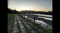
After Brookhouse it is necessary to cross the A683, where the traffic is quite fast, but there are always big gaps in the traffic for safe crossing. I walked a little way along the cycle track, but left it again for Caton, a quick pub visit, and the bus home, as it was now dark. I have walked the cycle track route to Lancaster from here many times and know it to be pleasant, easy, off-road and safe. It is the same route into Lancaster that I walked and described for LancHig Two: An interesting set of bridges at Crook o’ Lune, with picnic tables, a small car park, toilets, and a small burger and tea café open at weekends (Woodie’s). From here, the remainder of the route follows the former railway line, now a well maintained, tarmacked cycle track, past the Halton eco-village (which uses hydro-electric power from the river), Halton Station (now used by rowing clubs), under the M6, under the Lune Aqueduct, and right into Lancaster, all following the River Lune. A steep sloping footpath leads up past the Priory and the Castle (with views over to the Lake District) to the station.
Share your views about this route, give it a star rating, indicate whether it should be verified or not.
Include information that will be useful to others considering to walk or wheel it.
You can add up to 15 photos.
Other Routes for Lancaster—High Bentham See all Slow Ways
Review this better route and help establish a trusted network of walking routes.
Suggest a better route if it better meets our methodology.
Share your thoughts