Description
This is a Slow Ways route connecting Ilkeston and Kimberley.
Know of a better route? Share it here.
This is a Slow Ways route connecting Ilkeston and Kimberley.
Know of a better route? Share it here.
Status
This route has been reviewed by 4 people.
There are no issues flagged.
Photos for Ilkkim one


Photos of this route will appear when they are added to a review. You can review this route here.
Information
")
Route status - Live
Reviews - 4
Average rating -
Is this route good enough? - Yes (4)
There are currently no problems reported with this route.
Downloads - 4
Surveys
We are working to build-up a picture of what routes look like. To do that we are asking volunteers to survey routes so that we can communicate features, obstacles and challenges that may make a route desirable or not.
Slow Ways surveyors are asked to complete some basic online training, but they are not vetted. If you are dependent on the survey information being correct in order to complete a route, we recommend that you think critically about the information provided. You may also wish to wait until more than one survey has been completed.
Help people know more about this route by volunteering to submit a survey.
- Complete the survey training.
- Submit a survey for this route.
Geography information system (GIS) data
Total length
Maximum elevation
Minimum elevation
Start and end points
Ilkeston
Grid Ref
SK4647541729
Lat / Lon
52.97093° / -1.30941°
Easting / Northing
446,475E / 341,729N
What3Words
fully.they.island
Kimberley
Grid Ref
SK4994944748
Lat / Lon
52.99775° / -1.25722°
Easting / Northing
449,949E / 344,748N
What3Words
rotate.began.audit
Ilkkim One's land is
| Ilkeston | |
|---|---|
| Grid Ref | SK4647541729 |
| Lat / Lon | 52.97093° / -1.30941° |
| Easting / Northing | 446,475E / 341,729N |
| What3Words | fully.they.island |
| Kimberley | |
|---|---|
| Grid Ref | SK4994944748 |
| Lat / Lon | 52.99775° / -1.25722° |
| Easting / Northing | 449,949E / 344,748N |
| What3Words | rotate.began.audit |
| Arable | 47.7% |
| Pasture | 11.9% |
| Urban | 40.5% |
Data: Corine Land Cover (CLC) 2018
reviews
Hugh Hudson
07 Jan 2024 (edited 09 Jan 2024)Walked from Kimberley to Ilkeston. A good direct route with plenty of interest and fine views, but quite muddy in places.
From Kimberley, we head up James Street then left along High Street (presumably High physically as there are few facilities here) and cross the A610 on the road bridge. Here we go half right up Little Lane, which has no pavement but is quiet, then take the path (unsurfaced but not too muddy) up the left hand of the fields to Babbington Lane, where we go half right then take the signposted path sharp left through a little wooded area. The path then crosses a large open field with good views of the Erewash valley - this is a little waterlogged and muddy in places, A stile halfway down can easily be bypassed. The lane beyond is part surfaced but did have one large puddle which I managed to cross without my boots leaking.
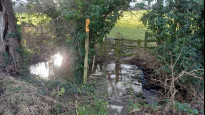
The lane eventually bends to the right, and we leave it to follow more field boundaries down the hill. More mud here. The path junction where we turn left is a little confusing, but the muddy farm track is the right of way down the first slope. Beyond the bridge a private sign makes it clear walkers are not welcome - the path crosses a little bridge (see picture 9 - the water was not as deep as it looks) then follows the left hand side of the fields up to Cossall, where we emerge at Church Cottage, which ha s D.H. Lawrence connections.
We cross the road and turn right, then take another slightly muddy path left to join the bridlepath, which crosses the Nottingham canal, which is disused but has water on both side here. The railway bridge offers a choice of steps or ramps, but neither crosses the tracks as shown by the OS bridleway. Still it is impossible to go wrong here, and the actual line is shorter if you can manage the steps. We then cross the Erewash and the Erewash Canal before following a mixture of residential streets, surfaced alleys and parkland into Ilkeston. Note that the right of way through Chaucer Old Park is misleading - there is no surfaced path along the perimeter of the park but there is a good surfaced path that cuts straight across and should really be used by all of the SlowWays routes that go this way.
StephenWalker
04 Feb 2022I walked this route from Kimberley in January. The section of fields between Swingate, Cossall and the railway were pretty slippery. There are also several rickety stiles to climb in this section. You need to be sensibly equipped. The exit for Kimberley and entry to Ilkeston are on quiet town roads.
-
Share your thoughts
Ken
26 Oct 2021A good urban area linking route along a mix of paths, some stiles north of Cossall others can be bypassed. Horses and sheep but fenced from the paths. Great bit of countryside and some good views to Crich Stand and Charnwood.
Leaving the Market Place with the once mighty Ilkeston Co-op headquarters behind me the route passes the side of a Wetherspoons, pass or enter the choice is yours. History under our feet, an inspection cover made by the Rutland Foundary, tells of the Duke of Rutland's involvement in this area. Locals will tell you the Duke still owns the mineral rights under their houses. The Erewash museum is next if you have the time for a look around. Dive under the bypass on this route and a few more houses before arriving at the canal and Potters Lock. As I passed a boat was heading north to Langley Mill, good to see the canal being used.
The bridge over the railway has ramps and all the way to Cossall is issue free. A brief look at the disused Nottingham canal as the route passes the site of a long gone bridge. The path across the paddock approaching Cossall is an excellent example of landowner care and consideration. The village has much of interest but no services. The Willoughby Almhouses looked unoccupied perhaps awaiting an upgrade. An interesting war memorial in the churchyard and that scandalous local author had an interest here.
Real open fields mostly given over to horses and some great views, north to Crich Stand and south to Charnwood Forest. Swingate stands on a high point hence the TV transmitter and the impressive tower of the Nottingham City Water Works reservoir, they don't build them like that any more.
Choices on the approach to Kimberley depending where you are destined to shop, work or play.
-
Share your thoughts
Nick Milson
22 Jul 2021Pleasant enough route once out of Ilkeston, towards Erewash Canal, through Cossall and good views on a clear day. Bit steep towards Babbington and a lot of stiles - Not suitable for wheelchair and pushchair users.
-
Share your thoughts
Share your views about this route, give it a star rating, indicate whether it should be verified or not.
Include information that will be useful to others considering to walk or wheel it.
You can add up to 15 photos.
Other Routes for Ilkeston—Kimberley See all Slow Ways
Review this better route and help establish a trusted network of walking routes.
Suggest a better route if it better meets our methodology.
Share your thoughts