Description
This is a Slow Ways route connecting Epping and Chipping Ongar.
Know of a better route? Share it here.
This is a Slow Ways route connecting Epping and Chipping Ongar.
Know of a better route? Share it here.
Status
This route has been reviewed by 3 people.
There are no issues flagged.
Photos for Eppchi one


Photos of this route will appear when they are added to a review. You can review this route here.
Information
")
Route status - Live
Reviews - 3
Average rating -
Is this route good enough? - Yes (3)
There are currently no problems reported with this route.
Downloads - 10
Surveys
We are working to build-up a picture of what routes look like. To do that we are asking volunteers to survey routes so that we can communicate features, obstacles and challenges that may make a route desirable or not.
Slow Ways surveyors are asked to complete some basic online training, but they are not vetted. If you are dependent on the survey information being correct in order to complete a route, we recommend that you think critically about the information provided. You may also wish to wait until more than one survey has been completed.
Help people know more about this route by volunteering to submit a survey.
- Complete the survey training.
- Submit a survey for this route.
Geography information system (GIS) data
Total length
Maximum elevation
Minimum elevation
Start and end points
Epping
Grid Ref
TL4619301556
Lat / Lon
51.69373° / 0.11380°
Easting / Northing
546,193E / 201,556N
What3Words
bonus.toned.supporter
Chipping Ongar
Grid Ref
TL5527202976
Lat / Lon
51.70405° / 0.24568°
Easting / Northing
555,272E / 202,976N
What3Words
fishery.goad.unless
Eppchi One's land is
| Epping | |
|---|---|
| Grid Ref | TL4619301556 |
| Lat / Lon | 51.69373° / 0.11380° |
| Easting / Northing | 546,193E / 201,556N |
| What3Words | bonus.toned.supporter |
| Chipping Ongar | |
|---|---|
| Grid Ref | TL5527202976 |
| Lat / Lon | 51.70405° / 0.24568° |
| Easting / Northing | 555,272E / 202,976N |
| What3Words | fishery.goad.unless |
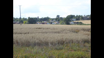
| Arable | 54.6% |
| Pasture | 14.1% |
| Urban | 12.9% |
| Woods | 18.4% |
Data: Corine Land Cover (CLC) 2018
reviews
Porcovolente
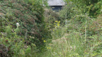
18 Aug 2023I walked this route from the Chipping Ongar end. Apart from a few residential streets it is all countryside and woodland making it a most enjoyable route. Mostly field edge walking or through broad woodland paths. Coming from this direction it is generally easy to follow the gpx map but there are a couple of places where it might be a bit confusing. After crossing the motorway you can turn immediately left or go straight ahead but whichever path you take gps will show you drifting off the route. In fact you need to walk straight ahead and you will find the path is on the left a bit further on and not clearly marked.
As remarked by another reviewer it is definitely a long trousers route as parts can be quite overgrown (very thistley when I walked) and although most parts of the route were dry and firm there were many indications that after wet weather they could be very muddy so I would recommend good boots in wet conditions. On the other hand if you time it right there is an abundance of blackberries and sloes that could be harvested.
Not suitable for push chairs and probably not bikes for some of the route although in places it would seem to be popular with mountain bikes judging by the tyre tracks dried into the ground. There is one place with a steep slope or broad steps which would be slippery in wet weather. Coming into Toot Hill there is a short section of road with very narrow verges but it seems to be quiet for traffic. Coming out onto the road at Stonnards Hill there are again narrow verges and quite fast traffic.
There are plenty of places to get food and drink in Chipping Ongar and a couple of pubs at points during the route though surprisingly little when you reach Epping station. One kiosk was open there and the centre of Epping is a good walk further on where there are plenty of shops.
Gavin P
16 Jun 2023Run this route 2 or 3 times a week, its part of the essex way, very well sign posted, little over grown at the moment in parts so would recommend trousers rather than shorts, very quiet, hardly ever see other walkers on parts of the route and a few good pubs on the route if your taking it slow
Nice mixture of forests and farmers fields
There is a bus that will take you back to the start but can be unreliable, only comes once an hour and very rarely on time.
-
Share your thoughts
Partas
02 May 2021Tested route from North Weald to Ongar and that is footpath almost all the way across fields and through woodland, except for Toot Hill where you walk a little way through the village. Need to keep an eye on the route in a few places as there are a few areas where the footpath is not well signposted (e.g. Toot Hill towards Ongar turn right at the house on the corner over a little metal bridge). Easy, accessible route with only one large uphill section.
-
Share your thoughts
Share your views about this route, give it a star rating, indicate whether it should be verified or not.
Include information that will be useful to others considering to walk or wheel it.
You can add up to 15 photos.
There are no other routes for Epping — Chipping Ongar
If you know a better way, then please let us know.
Review this better route and help establish a trusted network of walking routes.
Suggest a better route if it better meets our methodology.
Share your thoughts