Description
This is a Slow Ways route connecting Edinburgh and Loanhead.
Know of a better route? Share it here.
This is a Slow Ways route connecting Edinburgh and Loanhead.
Know of a better route? Share it here.
Status
This route has been reviewed by 2 people.
There are no issues flagged.
Photos for Ediloa one


Photos of this route will appear when they are added to a review. You can review this route here.
Information

Route status - Live
Reviews - 2
Average rating -
Is this route good enough? - Yes (2)
There are currently no problems reported with this route.
Downloads - 4
Surveys
We are working to build-up a picture of what routes look like. To do that we are asking volunteers to survey routes so that we can communicate features, obstacles and challenges that may make a route desirable or not.
Slow Ways surveyors are asked to complete some basic online training, but they are not vetted. If you are dependent on the survey information being correct in order to complete a route, we recommend that you think critically about the information provided. You may also wish to wait until more than one survey has been completed.
Help people know more about this route by volunteering to submit a survey.
- Complete the survey training.
- Submit a survey for this route.
Geography information system (GIS) data
Total length
Maximum elevation
Minimum elevation
Start and end points
Edinburgh
Grid Ref
NT2569673813
Lat / Lon
55.95157° / -3.19147°
Easting / Northing
325,696E / 673,813N
What3Words
shape.pads.choice
Loanhead
Grid Ref
NT2826065539
Lat / Lon
55.87764° / -3.14822°
Easting / Northing
328,260E / 665,539N
What3Words
stews.entry.struck
Ediloa One's land is
| Edinburgh | |
|---|---|
| Grid Ref | NT2569673813 |
| Lat / Lon | 55.95157° / -3.19147° |
| Easting / Northing | 325,696E / 673,813N |
| What3Words | shape.pads.choice |
| Loanhead | |
|---|---|
| Grid Ref | NT2826065539 |
| Lat / Lon | 55.87764° / -3.14822° |
| Easting / Northing | 328,260E / 665,539N |
| What3Words | stews.entry.struck |
| Arable | 3.4% |
| Green urban | 9.9% |
| Pasture | 20.4% |
| Urban | 66.3% |
Data: Corine Land Cover (CLC) 2018
reviews
MartinF
20 Sep 2023I walked this on a blustery afternoon in mid-September, the walk took me about 2h 20m. It is, in parts, a wonderful walk, but I have two concerns:
- The final section is along busy main roads, at some points crossing them with no lights.
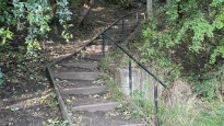
- The middle section is a great walk ... but is not accessible, or suitable for bikes as there are rough paths, significant numbers of steps, and steep sections.
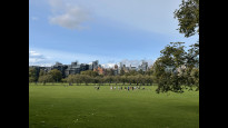
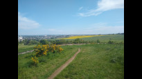
The walk is very much in three parts: the first part climbs from Waverley station through Old Town, across the Meadows and through some of Edinburgh's leafier suburbs. It's a good city walk, it passes some of Edinburgh's well-known attractions and covers a good cross-section of the city. I enjoyed this section. Like the previous reviewer Jconnolly, I'd probably take the News Steps, although there are 124 of them so the advertised route is less hard work. I'd also take Lovers Loan in preference to Kilgraston Road, but that's not a big deal. There are lots of bars, cafes and shops in Old Town and on the Meadows, a handful in Marchmont, and a coffee stand at the entrance to Blackford Pond - plenty of refreshment opportunities.
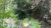
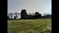
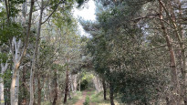
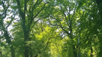
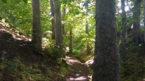
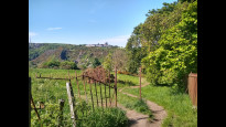
The second section is magnificent. From Blackford Pond, the path climbs the side of Blackford Hill through one of Edinburgh's oldest woods to the Observatory, then drops down to the Braid Burn, and climbs again up the beautiful Howe Dean path. It skirts Braids golf club, then swings through the Mortonhall estate, passing livery stables, open fields, a campground and a garden centre. It's one of my favourite areas to walk, and it must be some of the best green walking within city limits anywhere in the UK despite being less than 4 miles from the city centre. There are a couple of opportunities for refreshment towards the end of this section: the Stables is a pub with food, Mortonhall campground has a small shop, and Mortonhall Garden Centre also serves food.
The problem with the second section is that it is not accessible, and not suitable for bikes. You can probably work around that by skipping the Blackford Hill section, turning right at the Blackford Pond entrance and taking Cluny Gardens, Midmar Avenue, Midmar Drive, Hermitage Drive, Braid Road and Braid Hills Drive to the top of the Howe Dean Path and rejoining the main route. But that adds 1.5 miles.
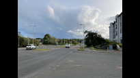
The final section is along busy main roads and honestly needs some attention. I did not enjoy crossing the Straiton roundabout at all, particularly crossing the on-ramp to the City Bypass without lights, which felt downright dangerous (at least the off-ramp had a pedestrian light). The whole section from Mortonhall Gate to Loanhead was accompanied by loud traffic noise, which seemed somehow to miss the point of Slow Ways. The previous reviewer Jconnolly has already suggested how to bypass much of Frogston Road by walking through Mortonhall Park. You could also cut through the estate between Frogston Road and Burdiehouse Road. But the major problem is crossing the bypass - there isn't an obvious alternative. Looking at a map, I think it should be possible to walk through Burdiehouse, cross the Burdiehouse Burn, walk through the Murrays and onto Lasswade Road, then pick up the Loanhead Railway Path all the way into Loanhead. But that does add another 1.5 miles. I'll see if I have time to go back and try that variant.
Overall though, this is a good walk, and takes you through some very nice parts of Edinburgh and out into the country.
Jconnolly
03 Jun 2021Took me 2.5 hours, including breaks.
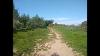
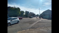
The middle section of this walk - about 3 miles/5km, from Blackford Pond to where you leave the Mortonhall Estate - is gorgeous, and took me to some places I didn't know about even though I've lived in the area most of my life. The rest is functional. Straiton roundabout (2nd last photo) kind of sucks, and could potentially be dangerous - there are pavements but not always traffic lights, and it's generally pretty busy - but I can't see a good way of avoiding it. I advise leaving Old Burdiehouse Road a bit sooner than the route suggests, going up to join the big road where the bus stop is. This lets you use the pedestrian crossing at that point, instead of having to either cross the A701/Burdiehouse Road without one or detour around the wrong side of the roundabouts and then the back of some shops... (although the latter doesn't actually add much distance to the route - so do whichever suits).
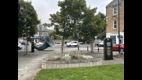
Straiton Pond Local Nature Reserve is nice if you have time for a detour! You'll see it signposted to your left shortly after the big roundabouts.
There are ways this route could have avoided the roads more, which I would have personally preferred. In town, the New Steps are challengingly steep, but more direct than wiggling up Market Street and the Mound. Then there's the Lover's Loan between Sciennes Road and Grange Loan. This would add about 300m to the route, but is a nice pedestrian alternative (and you can sometimes even find a blackberry or two, at that time of year). Finally, rather than walking along Frogston Road East you can turn left onto the path across a field between points 9 and 10 on the route and then take whatever path you want through the houses of Mortonhall (returning to the prescribed route at point 13) I took this route on my return journey, and found it more interesting and pleasant.
-
Share your thoughts
Share your views about this route, give it a star rating, indicate whether it should be verified or not.
Include information that will be useful to others considering to walk or wheel it.
You can add up to 15 photos.
There are no other routes for Edinburgh — Loanhead
If you know a better way, then please let us know.
Review this better route and help establish a trusted network of walking routes.
Suggest a better route if it better meets our methodology.
Share your thoughts