Description
The same as Chirom One but with the mapping errors taken out, the road crossing points made clearer and a small improvement
The same as Chirom One but with the mapping errors taken out, the road crossing points made clearer and a small improvement
Status
This route has been reviewed by 2 people.
There are no issues flagged.
Photos for Chirom two


Photos of this route will appear when they are added to a review. You can review this route here.
Information

Route status - Live
Reviews - 2
Average rating -
Is this route good enough? - Yes (2)
There are currently no problems reported with this route.
Downloads - 4
Surveys
What is this route like?
Surveys are submitted by fellow users of this website and show what you might expect from this Slow Ways route. Scroll down the page to read more detailed surveys.
| Grade 4X based on 1 surveys | Sign up or log in to survey this route. | ||
|---|---|---|---|
| Description | Note | ||
| Grade 4: Route includes very rough surfaces including deep ruts, steep loose gravel, unmade paths and deep muddy sections. Wheelchairs may experience traction/wheel spin issues. Access grade X: At least one stile, flight of steps or other obstacle that is highly likely to block access for wheelchair and scooter users. |
Grading is based on average scores by surveyors. This slow way has 1 surveys. | ||
| Full grading description | |||
Only people who have completed our training can become Slow Ways surveyors and submit a survey. We do not vet contributors, so we cannot guarantee the quality or completeness of the surveys they complete. If you are dependent on the information being correct we recommend reading and comparing surveys before setting off.
Survey Photos
Facilities
Facilities in the middle third of this route.
Challenges
Potential challenges reported on this route. Some challenges are seasonal.
Obstacles
Obstacles on this route.
Accessibility
Is this route step and stile free?
Measurements
Surveyors were asked to measure the narrowest and steepest parts of paths.
The narrowest part of the path is 35.0cm (1)
The steepest uphill gradient walking East 10.0% (1)
The steepest uphill gradient walking West 9.0% (1)
The steepest camber gradient across the path 3.0% (1)
How clear is the waymarking on the route: Unsigned (1)
Successfully completed
We asked route surveyors "Have you successfully completed this route with any of the following? If so, would you recommend it to someone with the same requirements?". Here is how they replied.
Recommended by an expert
We asked route surveyors "Are you a trained access professional, officer or expert? If so, is this route suitable for someone travelling with any of the following?" Here is how they replied.
Terrain
We asked route surveyors to estimate how much of the route goes through different kinds of terrain.
50.0% of the route is on roads (1)
50.0% of the route is lit at night (1)
50.0% of the route is paved (1)
30.0% of the route is muddy (1)
15.0% of the route is over rough ground (1)
15.0% of the route is through long grass (1)
Report a problem with this data
1 surveys
Information from verified surveys.
Geography information system (GIS) data
Total length
Maximum elevation
Minimum elevation
Start and end points
Chigwell
Grid Ref
TQ4370493045
Lat / Lon
51.61789° / 0.07432°
Easting / Northing
543,704E / 193,045N
What3Words
dame.remark.rots
Romford
Grid Ref
TQ5140488488
Lat / Lon
51.57493° / 0.18349°
Easting / Northing
551,404E / 188,488N
What3Words
crib.tribal.trio
| Chigwell | |
|---|---|
| Grid Ref | TQ4370493045 |
| Lat / Lon | 51.61789° / 0.07432° |
| Easting / Northing | 543,704E / 193,045N |
| What3Words | dame.remark.rots |
| Romford | |
|---|---|
| Grid Ref | TQ5140488488 |
| Lat / Lon | 51.57493° / 0.18349° |
| Easting / Northing | 551,404E / 188,488N |
| What3Words | crib.tribal.trio |
Sorry Land Cover data is not currently available for this route. Please check back later.
reviews
Daisy C
29 Dec 2023 (edited 09 Jan 2024)Not a bad route (bar seasonal wetness) but only just scraped 4/5. Nothing lifted it up for me, perhaps brighter weather would have done it. It was easy to follow and made good use of off road paths and green spaces as well as having transport links and resting points including a small park with picnic benches in Marks Gate. I started from Romford and encountered a lot of queueing traffic on Mawney Rd, I checked a parallel route via Mildmay Rd, much quieter, but not worth a new route. Crossing the A12 was easier than anticipated, there must be lights or something in both directions. All the road walking has pavements.
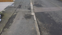
There are a few physical obstacles, two narrow squeezes between metal posts - width estimate under 40cm, and a mid-thigh metal bar/gate you have to step over by the A12. Sometimes the footpath signs were lacking. I think between Marks Gate and Hainault was even wetter with more extensive puddles than in Strider's photos . But not impassable, and other recent SW Essex walks had been soggier and stickier.
Good description of this route by Strider in his review. Also, ChiRom 1 is very similar and Carla's April 2022 review there describes positive features which I missed, and it sounds much drier. She also mentions that on Thursdays there is an enormous car boot sale on the route between Marks Gate and the A12.
Strider
29 Jan 2023I walked from Romford to Chigwell.
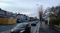
Starting at Romford station you pass through the pedestrianised shopping precinct (coffee!) then past houses to a subway under the ring road. More pavement walking to a cul-de-sac with a gate at the end. It is a bit of a squeeze to get around the gate into a field beside woods to the A12. Walk a short way along the road to a crossing place. There must be traffic lights beyond sight as the traffic comes in gobs with large gaps between which makes crossing not as difficult as it looks. Another narrow gap by a gate turn up into a field on the South side of the ditch, the vies improve as you climb. The path is muddy by the farm. More suburban walking through Marks Gate then more open fields with views of London to the west. It got very muddy close to the works with particularly sticky mud, this will be fine in dry weather rather than mid-Winter. A short walk alongside a busy road to a roundabout with a crossing refuge in the middle of the road. There is an opening through the hedge with bollard (again narrow) by the roundabout taking you across Hainault Recreation Ground and Playing fields, you may need to walk around the pitches if games are being played. There is a bench near the bowling green. Another busy road takes you past Hainault Station and the through a quiet housing estate, yes, there really is a school in Grange Hill! There’s bridge over a road through a green space the more suburban streets to Chigwell tube station.
A good walk with some nice views across open fields. Very narrow in parts and muddy when wet. Better in dry weather. Generally uphill to Chigwell, downhill to Romford.
-
Share your thoughts
Share your views about this route, give it a star rating, indicate whether it should be verified or not.
Include information that will be useful to others considering to walk or wheel it.
You can add up to 15 photos.
Other Routes for Chigwell—Romford See all Slow Ways
Review this better route and help establish a trusted network of walking routes.
Suggest a better route if it better meets our methodology.
Share your thoughts