Brierfield — Nelson
Brinel two

Slow Way not verified yet. Verify Brinel here.
Slow Way not verified yet. Verify Brinel here.
By Mary Oz on 03 Jul 2022
Description
This corrects a small discrepancy at the Nelson end where there is no direct access between the towpath and the road
This corrects a small discrepancy at the Nelson end where there is no direct access between the towpath and the road
Status
This route has been reviewed by 1 person.
There are no issues flagged.
Photos for Brinel two


Photos of this route will appear when they are added to a review. You can review this route here.
Information
Route status - Live
Reviews - 1
Average rating -
Is this route good enough? - Yes (1)
There are currently no problems reported with this route.
Downloads - 2
Surveys
What is this route like?
Surveys are submitted by fellow users of this website and show what you might expect from this Slow Ways route. Scroll down the page to read more detailed surveys.
| Grade 1X based on 1 surveys | Sign up or log in to survey this route. | ||
|---|---|---|---|
| Description | Note | ||
| Grade 1: Entirely smooth and compacted surfaces. Access grade X: At least one stile, flight of steps or other obstacle that is highly likely to block access for wheelchair and scooter users. |
Grading is based on average scores by surveyors. This slow way has 1 surveys. | ||
| Full grading description | |||
Only people who have completed our training can become Slow Ways surveyors and submit a survey. We do not vet contributors, so we cannot guarantee the quality or completeness of the surveys they complete. If you are dependent on the information being correct we recommend reading and comparing surveys before setting off.
Survey Photos
Facilities
Facilities in the middle third of this route.
Challenges
Potential challenges reported on this route. Some challenges are seasonal.
Obstacles
Obstacles on this route.
Accessibility
Is this route step and stile free?
Measurements
Surveyors were asked to measure the narrowest and steepest parts of paths.
The narrowest part of the path is 40.0cm (1)
The steepest uphill gradient walking East 16.0% (1)
The steepest uphill gradient walking West 16.0% (1)
The steepest camber gradient across the path 12.0% (1)
How clear is the waymarking on the route: Clear (1)
Successfully completed
We asked route surveyors "Have you successfully completed this route with any of the following? If so, would you recommend it to someone with the same requirements?". Here is how they replied.
Recommended by an expert
We asked route surveyors "Are you a trained access professional, officer or expert? If so, is this route suitable for someone travelling with any of the following?" Here is how they replied.
Terrain
We asked route surveyors to estimate how much of the route goes through different kinds of terrain.
25.0% of the route is on roads (1)
20.0% of the route is lit at night (1)
100.0% of the route is paved (1)
1.0% of the route is muddy (1)
There is no data on rough ground
There is no data on long grass
Report a problem with this data
1 surveys
Information from verified surveys.
Geography information system (GIS) data
Total length
Maximum elevation
Minimum elevation
Start and end points
Brierfield
Grid Ref
SD8453636433
Lat / Lon
53.82395° / -2.23640°
Easting / Northing
384,536E / 436,433N
What3Words
soft.spell.herbs
Nelson
Grid Ref
SD8601037686
Lat / Lon
53.83525° / -2.21407°
Easting / Northing
386,010E / 437,686N
What3Words
pencils.unimpeded.tries
| Brierfield | |
|---|---|
| Grid Ref | SD8453636433 |
| Lat / Lon | 53.82395° / -2.23640° |
| Easting / Northing | 384,536E / 436,433N |
| What3Words | soft.spell.herbs |
| Nelson | |
|---|---|
| Grid Ref | SD8601037686 |
| Lat / Lon | 53.83525° / -2.21407° |
| Easting / Northing | 386,010E / 437,686N |
| What3Words | pencils.unimpeded.tries |
Sorry Land Cover data is not currently available for this route. Please check back later.
review
Mary Oz
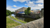
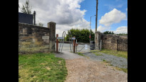
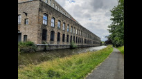
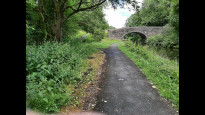
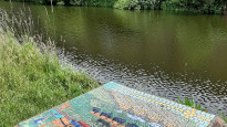
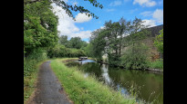
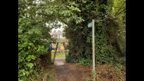
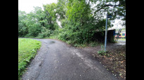
03 Jul 2022This route passes through several cycle barriers about 1.5m high, 40cm gap at the top, but a lot wider at the bottom. Other than that, this route looks pretty accessible to me as it is mostly on the towpath. At the Nelson end there is a tarmacked footpath, with a dog’s-leg to the right where a road is crossed, and there is a short bit of pavement at either end of the route too. The towpath is pleasant and interesting with lots of converted mills on the opposite side of the canal, and also several colourful mosaic panels of local scenes. There is quite a lot of noise from the M65 although mostly there are woods between the towpath and the motorway, so it is mostly not visible, at least in the summer.
Share your views about this route, give it a star rating, indicate whether it should be verified or not.
Include information that will be useful to others considering to walk or wheel it.
You can add up to 15 photos.
Other Routes for Brierfield—Nelson See all Slow Ways
Review this better route and help establish a trusted network of walking routes.
Suggest a better route if it better meets our methodology.
Share your thoughts