Description
This is a great way to walk between Bristol and Keynsham. I really enjoyed it and certainly recommend it to others.
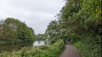
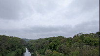
A large amount of the walk is in woodland along the River Avon and urban Bristol is just great to explore.
About a third of the route is on paths beside roads and there is a fast and busy crossing (with no lights) over the A4174. You will need to be patient to wait for safe gaps in the fast moving traffic. There are steps, stiles and some short steepish slopes
This is a great way to walk between Bristol and Keynsham. I really enjoyed it and certainly recommend it to others.
A large amount of the walk is in woodland along the River Avon and urban Bristol is just great to explore.
About a third of the route is on paths beside roads and there is a fast and busy crossing (with no lights) over the A4174. You will need to be patient to wait for safe gaps in the fast moving traffic. There are steps, stiles and some short steepish slopes
Status
This route has been reviewed by 5 people.
This route has been flagged (1 times) for reasons relating to safety.
Photos for Brikey three


Photos of this route will appear when they are added to a review. You can review this route here.
Information
")
Route status - Live
Reviews - 5
Average rating -
Is this route good enough? - Yes (4) No (1)
Problems reported - Safety (1)
Downloads - 6
Surveys
What is this route like?
Surveys are submitted by fellow users of this website and show what you might expect from this Slow Ways route. Scroll down the page to read more detailed surveys.
| Grade 2X based on 1 surveys | Sign up or log in to survey this route. | ||
|---|---|---|---|
| Description | Note | ||
| Grade 2: Mostly smooth and compacted surfaces, but there may be some loose gravel, muddy patches or cobbles. Access grade X: At least one stile, flight of steps or other obstacle that is highly likely to block access for wheelchair and scooter users. |
Grading is based on average scores by surveyors. This slow way has 1 surveys. | ||
| Full grading description | |||
Only people who have completed our training can become Slow Ways surveyors and submit a survey. We do not vet contributors, so we cannot guarantee the quality or completeness of the surveys they complete. If you are dependent on the information being correct we recommend reading and comparing surveys before setting off.
Survey Photos

Facilities
Facilities in the middle third of this route.
Challenges
Potential challenges reported on this route. Some challenges are seasonal.
Obstacles
Obstacles on this route.
Accessibility
Is this route step and stile free?
Measurements
Surveyors were asked to measure the narrowest and steepest parts of paths.
The narrowest part of the path is 30.0cm (1)
The steepest uphill gradient walking East 50.0% (1)
The steepest uphill gradient walking West 42.0% (1)
The steepest camber gradient across the path 10.0% (1)
How clear is the waymarking on the route: Unclear in places (1)
Successfully completed
We asked route surveyors "Have you successfully completed this route with any of the following? If so, would you recommend it to someone with the same requirements?". Here is how they replied.
Recommended by an expert
We asked route surveyors "Are you a trained access professional, officer or expert? If so, is this route suitable for someone travelling with any of the following?" Here is how they replied.
Terrain
We asked route surveyors to estimate how much of the route goes through different kinds of terrain.
0.0% of the route is on roads (1)
33.0% of the route is lit at night (1)
58.0% of the route is paved (1)
8.0% of the route is muddy (1)
8.0% of the route is over rough ground (1)
0.0% of the route is through long grass (1)
Report a problem with this data
1 surveys
Information from verified surveys.
Geography information system (GIS) data
Total length
Maximum elevation
Minimum elevation
Start and end points
Bristol
Grid Ref
ST5894073546
Lat / Lon
51.45939° / -2.59239°
Easting / Northing
358,940E / 173,546N
What3Words
dollar.perky.study
Keynsham
Grid Ref
ST6547768493
Lat / Lon
51.41439° / -2.49780°
Easting / Northing
365,477E / 168,493N
What3Words
preoccupied.grape.launch
| Bristol | |
|---|---|
| Grid Ref | ST5894073546 |
| Lat / Lon | 51.45939° / -2.59239° |
| Easting / Northing | 358,940E / 173,546N |
| What3Words | dollar.perky.study |
| Keynsham | |
|---|---|
| Grid Ref | ST6547768493 |
| Lat / Lon | 51.41439° / -2.49780° |
| Easting / Northing | 365,477E / 168,493N |
| What3Words | preoccupied.grape.launch |
Sorry Land Cover data is not currently available for this route. Please check back later.
reviews
Brian
23 May 2023Oh dear, this the second Slow Way running that I am at odds with the review ratings. Yes there are some very good parts to this walk ( which is why I gave it two stars ), but frankly whilst Dan says crossing the A4174 is do-able, yes it is, but it took me 7 minutes to cross, and even then I had to move at a lick to avoid the next batch of on-rushing cars, so from my personal perspective, I think it is dangerous. I also found the climb up from the river path up to the A4174 at Bickley Wood very steep, and no doubt, exceptionally slippery after rain. I think Panifex has made a correct suggestion, of a route not having to cross this road. I assume that there is a path adjacent to the road all the way along.
Within this route, there is 1 stile, 4 sets of steps ( 18/26/3/ and 25 ) and 3 gates
I recorded the route on GPS at 7.80 mi
I would suggest two options for Brikey
1 ) A new formal route is created based on Panifex alternative
2 ) A further route which continues along the riverside path, all the way to the A4175, this would be a walk of 8.40 mi, compared to this walk of 7.30 mi.
Panifex
10 Dec 2022Completely agree with all the other reviews - what a wonderful walk, even on a cold and frosty December morning. I think some of the paths would have been muddy if they weren't frozen.
As one of the previous reviewers mentioned, it isn't necessary to cross the A4174 - coming from Keynsham, stay on the left of the road until you get to a footpath which takes you under the bridge. I thought about making a new route to show that, but instead I've just uploaded a picture below. Should it ever be possible to do minor updates to verified routes, this change should probably included.
Overall, this has been one of my favourite slow ways so far.
-
Panifex
10 Dec 2022Obviously, when I say "left" I mean "right" :-)
-
Share your thoughts
Tony Parsons
25 Aug 2022I know this route well as I live near Bristol, The route is very pleasant following the valley of the river Avon. It is hard to imagine that only a short distance over the tops of the valley are housing estates. The valley is particularly pleasant in autumn with coloured leaves on the trees.
A lot of the route is popular with cyclists.
The section east of the ring road can sometimes be muddy and narrow in places. However the council (BANES) has told me that they will soon bee working to improve it.
-
Danravenellison
25 Aug 2022Hi Tony! Fantastic. Really pleased this route is verified now! To thanks.
-
Share your thoughts
Katherine
22 Aug 2022The route worked really well for walking, but would need some adjustment for cyclists due to steep/narrow sections, stiles and gravel paths. I'd recommend walking right next to the canal on Feeder Road rather than on the pavement as the pavement is very narrow in places and there are a lot of noisy lorries barreling past.
I stopped for a picnic next to the car park in Conham River Park, which has toilets and benches and is roughly halfway along the route. I know there's sometimes a coffee truck there too for refreshments! There's also some good blackberry picking between Netham Park and Conham River Park for keen foragers.
The crossing over the A4174 looks intimidating, but there's actually a crossing point (just no lights). You have to do a little zig-zag to get across following the marked footpath and the route map clearly shows that.
The section after the A4174 crossing was a bit overgrown, but pretty fun because of that! You get into Keynsham shortly after and there's lots of cafes to reward you. Loved it!.
-
Share your thoughts
Danravenellison
03 May 2022I really enjoyed walking this route. If you are walking into Bristol from the east it's a great way to enter the city. If you are local, it's worth getting the train to Bristol or Keynsham and walking back to the other again.
The River Avon is the real treat.
I made this route in response to comments on Brikey One. The route is slightly further, but incredibly more easy to follow. Unless you are looking for a more direct, accessible route or new-white-shoe friendly route.. it's worth walking the extra KM to go this way I'm sure.
I checked this route while having a walking meeting and so did not take as many photos as I usually would. There are steps, stiles and some steep slopes. It will be muddy after it's been raining for a while too.
The route does not get five stars from me because of the crossing over the A4174 which is a fast dual carriageway. There is a formal path and an island half way, but no controlled lights and the traffic is fast. It's doable, but patience may be required. The stretch along Feeder road is quite long too, but you can get down to walk alongside the water.. so look out for that.
That all said, I'd 100% enjoy walking it again.
-
Share your thoughts
Share your views about this route, give it a star rating, indicate whether it should be verified or not.
Include information that will be useful to others considering to walk or wheel it.
You can add up to 15 photos.
Other Routes for Bristol—Keynsham See all Slow Ways
Review this better route and help establish a trusted network of walking routes.
Suggest a better route if it better meets our methodology.
Share your thoughts