Description
This is a Slow Ways route connecting Biggin and Ashbourne.
Know of a better route? Share it here.
This is a Slow Ways route connecting Biggin and Ashbourne.
Know of a better route? Share it here.
Status
This route has been reviewed by 2 people.
There are no issues flagged.
Photos for Bigash two


Photos of this route will appear when they are added to a review. You can review this route here.
Information

Route status - Live
Reviews - 2
Average rating -
Is this route good enough? - Yes (2)
There are currently no problems reported with this route.
Downloads - 13
Surveys
We are working to build-up a picture of what routes look like. To do that we are asking volunteers to survey routes so that we can communicate features, obstacles and challenges that may make a route desirable or not.
Slow Ways surveyors are asked to complete some basic online training, but they are not vetted. If you are dependent on the survey information being correct in order to complete a route, we recommend that you think critically about the information provided. You may also wish to wait until more than one survey has been completed.
Help people know more about this route by volunteering to submit a survey.
- Complete the survey training.
- Submit a survey for this route.
Geography information system (GIS) data
Total length
Maximum elevation
Minimum elevation
Start and end points
Biggin
Grid Ref
SK1547359371
Lat / Lon
53.13130° / -1.77020°
Easting / Northing
415,473E / 359,371N
What3Words
mistress.workbench.helper
Ashbourne
Grid Ref
SK1806646458
Lat / Lon
53.01514° / -1.73216°
Easting / Northing
418,066E / 346,458N
What3Words
reefs.compacts.single
Bigash Two's land is
| Biggin | |
|---|---|
| Grid Ref | SK1547359371 |
| Lat / Lon | 53.13130° / -1.77020° |
| Easting / Northing | 415,473E / 359,371N |
| What3Words | mistress.workbench.helper |
| Ashbourne | |
|---|---|
| Grid Ref | SK1806646458 |
| Lat / Lon | 53.01514° / -1.73216° |
| Easting / Northing | 418,066E / 346,458N |
| What3Words | reefs.compacts.single |
| Pasture | 74.6% |
| Urban | 3.7% |
| Woods | 21.7% |
Data: Corine Land Cover (CLC) 2018
reviews
Jo Wood
24 Aug 2023A great route for connecting Biggin (or perhaps more usefully, Hartington) with Ashbourne. It is not quite as direct as the Tissington Trail taken in BigAshOne, but much more interesting, being largely along bottom the dramatic limestone Mill Dale and Dove Dale. We walked from Biggin to Ashbourne in good weather.
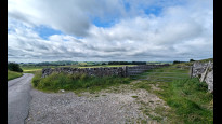
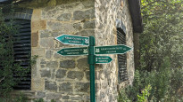
The first 4km are through open farmland, with paths mostly through the fields rather than along their edges (photos 1 and 2). These are only partially signposted, so consulting the map/GPX is useful here. I think a route along the prettier and flatter Biggin Dale would be a better way of joining the main dale for this stretch and would be more fitting for a largely valley bottom route.
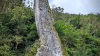
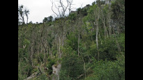
The more interesting part of the walk starts once you descend down into the dale where you follow the river downstream on a good and flat path through the steeply incised limestone valleys. There's a useful snack stop at "Polly's Cottage" at the beautiful Milldale village (hot chocolate, Bakewell slices, Paracetamol and duck food all available!). As you continue following the river from Mill Dale to Dove Dale, there are plenty of interesting limestone features including some well-known visitor honeypots (Ilam rock, Lovers' Leap, Dovedale Stepping Stones, Thorpe Cloud; photos 5, 6, 7 and 10) that make this a spectacular route. This is an area of important upland Ash woodland but there is sadly evidence of extensive Ash dieback (photo 9) in places.
The path departs the dale at the famous stepping stones and Thorpe Cloud (photo 10) and then it's back to mostly open farmland for around 4km until the outskirts of Ashbourne. The 442 bus runs between Ashbourne, Tissington, Biggin and Hartington making this an easy for a there and back day out. Highly recommended.
Malcolm Boura
02 May 2021Either Bigash One or Bigash Two should use the path starting about 30 metres further north on the Tissington Trail to the northern end of Callow Top Camp Site. That avoids climbing a significant hill out of Mapleton and it is shorter.
Hartington is a much better place for these routes to end than Biggin. It is a lot larger and has much better facilities.
-
Malcolm Boura
18 Mar 2022At the northern end Biggin Dale is a better route.
-
Share your thoughts
Share your views about this route, give it a star rating, indicate whether it should be verified or not.
Include information that will be useful to others considering to walk or wheel it.
You can add up to 15 photos.
Other Routes for Biggin—Ashbourne See all Slow Ways
Review this better route and help establish a trusted network of walking routes.
Suggest a better route if it better meets our methodology.
Share your thoughts