Yate — Wotton-under-Edge
Yatwot two

Slow Way not verified yet. Verify Yatwot here.
Slow Way not verified yet. Verify Yatwot here.
By Mockymock on 12 Feb 2023
Description
A route which is the same as Yatwot one, but with a corrected line of access through new housing at the edge of Yate, and one or two minor alterations where the current route of the path differs a little from that shown on the OS map
A route which is the same as Yatwot one, but with a corrected line of access through new housing at the edge of Yate, and one or two minor alterations where the current route of the path differs a little from that shown on the OS map
Status
This route has been reviewed by 2 people.
There are no issues flagged.
Photos for Yatwot two


Photos of this route will appear when they are added to a review. You can review this route here.
Information
Route status - Live
Reviews - 2
Average rating -
Is this route good enough? - Yes (2)
There are currently no problems reported with this route.
Downloads - 4
Surveys
What is this route like?
Surveys are submitted by fellow users of this website and show what you might expect from this Slow Ways route. Scroll down the page to read more detailed surveys.
| Grade 4X based on 1 surveys | Sign up or log in to survey this route. | ||
|---|---|---|---|
| Description | Note | ||
| Grade 4: Route includes very rough surfaces including deep ruts, steep loose gravel, unmade paths and deep muddy sections. Wheelchairs may experience traction/wheel spin issues. Access grade X: At least one stile, flight of steps or other obstacle that is highly likely to block access for wheelchair and scooter users. |
Grading is based on average scores by surveyors. This slow way has 1 surveys. | ||
| Full grading description | |||
Only people who have completed our training can become Slow Ways surveyors and submit a survey. We do not vet contributors, so we cannot guarantee the quality or completeness of the surveys they complete. If you are dependent on the information being correct we recommend reading and comparing surveys before setting off.
Survey Photos
Facilities
Facilities in the middle third of this route.
Challenges
Potential challenges reported on this route. Some challenges are seasonal.
Obstacles
Obstacles on this route.
Accessibility
Is this route step and stile free?
Measurements
Surveyors were asked to measure the narrowest and steepest parts of paths.
The narrowest part of the path is 40.0cm (1)
The steepest uphill gradient East: no data
The steepest uphill gradient West: no data
The steepest camber: no data
How clear is the waymarking on the route: Unclear in places (1)
Successfully completed
We asked route surveyors "Have you successfully completed this route with any of the following? If so, would you recommend it to someone with the same requirements?". Here is how they replied.
Recommended by an expert
We asked route surveyors "Are you a trained access professional, officer or expert? If so, is this route suitable for someone travelling with any of the following?" Here is how they replied.
Terrain
We asked route surveyors to estimate how much of the route goes through different kinds of terrain.
5.0% of the route is on roads (1)
10.0% of the route is lit at night (1)
15.0% of the route is paved (1)
5.0% of the route is muddy (1)
5.0% of the route is over rough ground (1)
1.0% of the route is through long grass (1)
Report a problem with this data
1 surveys
Information from verified surveys.
Geography information system (GIS) data
Total length
Maximum elevation
Minimum elevation
Start and end points
Yate
Grid Ref
ST7146482599
Lat / Lon
51.54156° / -2.41286°
Easting / Northing
371,464E / 182,599N
What3Words
solve.mice.shut
Wotton-under-Edge
Grid Ref
ST7585093389
Lat / Lon
51.63878° / -2.35036°
Easting / Northing
375,850E / 193,389N
What3Words
sway.rejoins.search
| Yate | |
|---|---|
| Grid Ref | ST7146482599 |
| Lat / Lon | 51.54156° / -2.41286° |
| Easting / Northing | 371,464E / 182,599N |
| What3Words | solve.mice.shut |
| Wotton-under-Edge | |
|---|---|
| Grid Ref | ST7585093389 |
| Lat / Lon | 51.63878° / -2.35036° |
| Easting / Northing | 375,850E / 193,389N |
| What3Words | sway.rejoins.search |
Sorry Land Cover data is not currently available for this route. Please check back later.
reviews
Hugh Hudson
23 Aug 2023 (edited 24 Aug 2023)Walked from Wotton to Yate. This looks quite a good route on the map, but is let down by the neglect of two sections of field path. The worst is from Hillesley Road to Inglestone Farm. This starts with a gate I had to climb because it was too stiff to open. There are a few stiles or hedge gaps that are too overgrown to be comfortable and near Haroldsfield Farm there were electric fences either side of a farm road through a pasture full of bullocks, with no provision for the walker to cross them. And the new orchard with no trodden path. There were also similar but lesser issues with the path SW of Wickwar, and I must admit that having battled through those, I would have appreciated a more direct route into Yate too.
Apart from that it is a good walk with fine scenery.
From Wotton, we head south past the main shopping street onto a small lane, beyond which a good path with a few steps leads us down to and across Dyers Brook. The path across the fields to Nind Farm is well labelled and obviously trodden. A short section of quiet road takes us to Hillesley Road, where the problem section begins with a gate that I couldn't open and had to climb. The first few fields are easy enough to cross (the first one lends itself to a shortcut). I followed the GPX line away from the definitive route and beyond that had to squeeze through a narrow and overgrown gap in the hedge, then find my own line through a recently harvested bean field. Beyond that was the bullock field with electric fences (I crawled under those having waited for the bullocks to get bored). There is plenty of evidence of footpath infrastructure (no deliberate destruction of stiles) but the new trees also slowed progress as they are growing in long grass without much of a path.
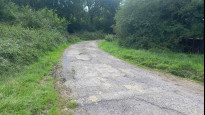
I didn't realise that the well cut field beyond was a polo field until I read Mockymock's review. Here things improve as the next two fields are crossed on a farm track, but it is easy to get distracted by the farm track that heads directly to Inglestone Farm which is not a right of way, and there is no trodden line to the right place to cross the ditch. Beyond another fence provides a minor obstruction and the route through the farm's garden is not well labelled either. So the road is reached with a strong sense of relief, and from here the route into Wickwar is good, becoming more trodden beyond the first large field. The steep down and up across the Little Avon is unavoidable and has a good bridge.
Wickwar has a pub just off route and a licensed social club on it, but I didn't spot any shops. We follow a path around houses then across fields on a well trodden and cut path, but where the path divides our route takes us into a pasture bisected by an electric fence (no obvious crossing point), and once out of that field the next one is protected by a barbed wire fence. I didn't investigate left but found a climbable gate on the left edge of the field, and at the far end there is a good bridge, beyond which the GPX shows the diverted path line well.
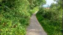
Beyond the road the paths look better used and well labelled, and the rest of the walk to Yate Rocks is enjoyable. We are then into the new houses (through another garden), and the rest of the route is a mixture of suburban residential streets and paths through gaps in the houses and nature reserves (some of these are unsurfaced and have muddy sections). Eventually we head right into the centre and cross Station Road to the Yate meeting point outside the shopping centre. No benches here but there are a couple on the walk out to the railway station.
Mockymock
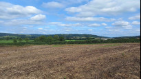
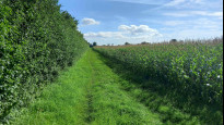
12 Feb 2023A generally very enjoyable route, mainly through rolling farmland pastures and arable fields, with an urban fringe nature reserve, some woodland edge and a corner of one of those big South Gloucestershire commons thrown in along the way. It just has one half-mile section through some arable fields with poor signage and rotting path infrastructure which, though perfectly walkable, was a bit annoying. Otherwise great.
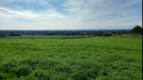
The Slow Way leaves Yate on quiet roads and paths via green spaces among housing and a path through a woodland nature reserve, leaving the town via the village of Yate Rocks, where it heads first into the valley, briefly on the Jubilee Way, but soon climbs away to track along a low ridge with extensive views west, and eventually reaches the village of Wickwar, where there is a tea room and a pub at the northern end of the high street. This first part of the route looks to be regularly walked and has good signage.
From Wickwar the route heads east down into a stream valley via an equine facility with grazing horses and up again to meet a lane along the western arm of Inglestone Common running along the northern edge of Lower Woods nature reserve. Again, this area is well signed and the route easy to navigate.
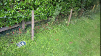
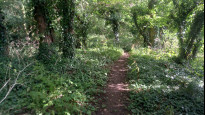
By Inglestone Farm the Slow Way turns north again through more farmland. From here until you reach the next road a mile and a half or so further on, the signage is often absent and some of the path infrastructure in a poor state of repair, but it is all walkable. The route initially crosses a brook and heads through a little planted-up paddock where the path is not so obvious. Just fiddle through the trees and head for the northwestern corner. The next half a mile is through pastures grazed by polo ponies and, at one point, the line of the footpath crosses a polo pitch that you might have to skirt round if there was any action in the summer. The way out of this field via a footbridge is hard to see heading in this direction but it is there, hiding in the hedge to the left of the corner of the field. This leads into a newly planted woodland with saplings in plastic tubes. There is a sort-of path developing through the tussocky grass along the line of the right if way in the general direction of the exit. Again, just fiddle through.
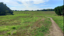
From here the Cotswold Edge gradually comes into view and at this point there are some arable fields to cross which may well have no obvious route through when there is standing crop but were fine at this time of year, though claggy underfoot. There are some wet ditches in front of some of the hedges in this area with railway sleeper planks to help walkers get across to the stiles. One of these was missing and there was a small swamp to negotiate, while one stile was completely collapsed. Yet another lay to the west of the route shown on the OS map on the line of an adjacent right of way (the plot of the Slow Way shows accurately where it is) but it was all still walkable and there is a nice view ahead.
Once you cross the next road and walk on up the quiet lane past Nind Farm towards the hill up to Wotton, signs reappear, the paths are well-walked again, and it is plain sailing once more, barring the odd muddy gateway. The Slow Way makes a moderate ascent up into the town, first through fields, with nice views back south, and then via various alleys, village lanes and scrubby hinterlands.
Loads of climbover stiles on this route, some steps and plenty of livestock, including many horses. It is mainly gently sloping terrain, with one or two moderate ups and downs.
-
Share your thoughts
Share your views about this route, give it a star rating, indicate whether it should be verified or not.
Include information that will be useful to others considering to walk or wheel it.
You can add up to 15 photos.
Other Routes for Yate—Wotton-under-Edge See all Slow Ways
Review this better route and help establish a trusted network of walking routes.
Suggest a better route if it better meets our methodology.
Share your thoughts