Woolwich — Abbey Wood
Wooabb two

Slow Way not verified yet. Verify Wooabb here.
Slow Way not verified yet. Verify Wooabb here.
By Daisy C on 24 Oct 2022
Description
This route uses quiet roads and The Ridgeway, a local green raised walking/cycle route. It goes through the new developments at Woolwich so you could take a detour to look at the old Royal Arsenal Buildings, Arts Centre or have a pitstop with Antony Gormley sculptures by the riverside. It's around 40% off road and the only noisy roads are between Woolwich Town Centre and the A206 crossing.
There may be minor shortcuts you could take but this route is easy to navigate and quiet. The Plumstead interchange is a slight exception using paths beneath the flyovers and one underpass. It avoids the large road junctions, curling ramp, traffic lights, pedestrian bridges and the hot mess of signage and street furniture. It's not ideal, but it's not bad, there are pedestrian signs and it's' better than the high level alternative . The map should be useful and be easier to interpret on the ground.
There are anti-motorbike width restrictions at both entrances to The Ridgeway. But at the eastern entrance there is a ramp as well as the stairs shown in the photo
Status
This route has been reviewed by 2 people.
There are no issues flagged.
Photos for Wooabb two


Photos of this route will appear when they are added to a review. You can review this route here.
Information
Route status - Live
Reviews - 2
Average rating -
Is this route good enough? - Yes (2)
There are currently no problems reported with this route.
Downloads - 6
Surveys
We are working to build-up a picture of what routes look like. To do that we are asking volunteers to survey routes so that we can communicate features, obstacles and challenges that may make a route desirable or not.
Slow Ways surveyors are asked to complete some basic online training, but they are not vetted. If you are dependent on the survey information being correct in order to complete a route, we recommend that you think critically about the information provided. You may also wish to wait until more than one survey has been completed.
Help people know more about this route by volunteering to submit a survey.
- Complete the survey training.
- Submit a survey for this route.
Geography information system (GIS) data
Total length
Maximum elevation
Minimum elevation
Start and end points
Woolwich
Grid Ref
TQ4372878823
Lat / Lon
51.49009° / 0.06885°
Easting / Northing
543,728E / 178,823N
What3Words
legend.tester.drives
Abbey Wood
Grid Ref
TQ4738479026
Lat / Lon
51.49098° / 0.12157°
Easting / Northing
547,385E / 179,026N
What3Words
mixer.swift.palace
| Woolwich | |
|---|---|
| Grid Ref | TQ4372878823 |
| Lat / Lon | 51.49009° / 0.06885° |
| Easting / Northing | 543,728E / 178,823N |
| What3Words | legend.tester.drives |
| Abbey Wood | |
|---|---|
| Grid Ref | TQ4738479026 |
| Lat / Lon | 51.49098° / 0.12157° |
| Easting / Northing | 547,385E / 179,026N |
| What3Words | mixer.swift.palace |
Sorry Land Cover data is not currently available for this route. Please check back later.
reviews
Derick Rethans
24 Mar 2024I walked this from Abbey Wood to Woodwich on a sunny afternoon. It had rained earlier in the day.
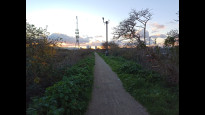
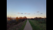
The first third is along quiet residential roads, first following the railway (photo #1), before heading north (photo #2) towards the Ridgeway. It follows this for the middle third (photo #3, #4), and is lovely, with interesting views of old industrial bits, and new residential (photo #5) bits north and south. Crossing underneath the flyovers at Plumstead was easy enough. And then the last third was along more (new) residential streets (photo #6, #7).
A good route, but too much urban walking to my liking.
Daisy C
07 Dec 2022 (edited 09 Jul 2023)Overall I enjoyed this route, it was easy to navigate and either no- or low- traffic except a short bit between the Plumstead underpass junction and the beginning of the residential developments at Woolwich Arsenal . The surroundings were diverse enough to keep my interest and I always enjoy using green routes through urban areas. At the Plumstead Ridgeway/underpass junction there are a lot of options and turnings which is a bit of a pain but this way through is the simplest of the options I think.
Starting at Abbey Wood the residential roads were greener than expected and very low in traffic despite it being school pick up time (for a surprisingly dense population of schools). i considered a different route between the housing as it looked greener on the map but I think it would be quite maze like and this is easier to follow.
The Ridgeway path is green and quite wild (not overgrown though) which gives some sense of distance from the sometimes noisy industrial sites either side, they are currently mixed in with wild brownfield sites but that might not last. The flip side of that is isolation which is probably not great at night, I felt perfectly safe until I started thinking about it, but there's no lighting and exits are quite widely spaced. The only other woman I saw (at around dusk on a winter afternoon) was moving fast on her electric scooter.
Road towards Woolwich Arsenal is terribly easy to navigate. It does have a bit more traffic but is still quiet for the area, as the only destination beyond is the residential developments. It starts out passing some commercial buildings, but that gradually shifts to new development which has built around (gentrified) buildings from the historic naval/industrial era.
The approach to the meeting point (buses and National Rail station) goes right past the DLR and new Elizabeth line stations so you're spoilt for public transport options.
Note for exiting the Ridgeway path. All the exits look fairly similar so if Abbey Wood is your destination take the first one once the south side becomes residential. At the Plumstead end, if you (like me) miss the last turn off then you'll end at the high level end point which leads onto the roads, where you could get a train or buses but it isn't terribly pedestrian friendly and you'll have missed the onward route via Mallard Path, so take the path down and back to the right which soon turns again to the low level exit. It's probably easier than following the official route.
-
Share your thoughts
Share your views about this route, give it a star rating, indicate whether it should be verified or not.
Include information that will be useful to others considering to walk or wheel it.
You can add up to 15 photos.
Other Routes for Woolwich—Abbey Wood See all Slow Ways
Review this better route and help establish a trusted network of walking routes.
Suggest a better route if it better meets our methodology.
Share your thoughts