Wiveliscombe — Wellington, Somerset
Wivwel two

Slow Way not verified yet. Verify Wivwel here.
Slow Way not verified yet. Verify Wivwel here.
By Tim Ryan on 03 Dec 2021
Description
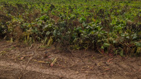
A alternative to Wivwel 1 through Wellington, because of footpath closure. A nice route through open countryside. At the time of this review (Dec.21) the path around the Haywood Farm Estate at Nynehead was unclear and muddy, having recently been ploughed and not reinstated. However once around this the route is fine in either direction
A alternative to Wivwel 1 through Wellington, because of footpath closure. A nice route through open countryside. At the time of this review (Dec.21) the path around the Haywood Farm Estate at Nynehead was unclear and muddy, having recently been ploughed and not reinstated. However once around this the route is fine in either direction
Status
This route has been reviewed by 3 people.
This route has been flagged (1 times) for reasons relating to access.
Photos for Wivwel two


Photos of this route will appear when they are added to a review. You can review this route here.
Information
Route status - Live
Reviews - 3
Average rating -
Is this route good enough? - Yes (2) Maybe (1)
Problems reported - Access (1)
Downloads - 3
Surveys
We are working to build-up a picture of what routes look like. To do that we are asking volunteers to survey routes so that we can communicate features, obstacles and challenges that may make a route desirable or not.
Slow Ways surveyors are asked to complete some basic online training, but they are not vetted. If you are dependent on the survey information being correct in order to complete a route, we recommend that you think critically about the information provided. You may also wish to wait until more than one survey has been completed.
Help people know more about this route by volunteering to submit a survey.
- Complete the survey training.
- Submit a survey for this route.
Geography information system (GIS) data
Total length
Maximum elevation
Minimum elevation
Start and end points
Wiveliscombe
Grid Ref
ST0807427816
Lat / Lon
51.04231° / -3.31262°
Easting / Northing
308,074E / 127,816N
What3Words
explored.lightens.responses
Wellington, Somerset
Grid Ref
ST1405720774
Lat / Lon
50.97993° / -3.22563°
Easting / Northing
314,057E / 120,774N
What3Words
proofread.lotteries.prestige
| Wiveliscombe | |
|---|---|
| Grid Ref | ST0807427816 |
| Lat / Lon | 51.04231° / -3.31262° |
| Easting / Northing | 308,074E / 127,816N |
| What3Words | explored.lightens.responses |
| Wellington, Somerset | |
|---|---|
| Grid Ref | ST1405720774 |
| Lat / Lon | 50.97993° / -3.22563° |
| Easting / Northing | 314,057E / 120,774N |
| What3Words | proofread.lotteries.prestige |
Sorry Land Cover data is not currently available for this route. Please check back later.
reviews
Clare Mitchell
20 Nov 2023Sadly this route was not great. We were staying half way along it so the plan was to walk one half then the other but we abandoned it after one half. Part of the problem was the mud after the torrential rain that there had been. That would have been manageable. However the route is blocked at Heywood farm by at least 2 electric fences. We managed to cross one but gave up at the next. Instead we walked through the farm yard (not a right of way) which was a bit off putting as it was next to a clay shooting range. The bit of the footpath we did manage was also covered in clays. Problem has been reported. The next field, heading south, was full of crops so we diverted along the lanes.
I'm sure that once the path is open again and it stops raining it will be a lovely route.
Charles Hedley
22 Jul 2022I walked this route in the Wiveliscombe to Wellington direction on a lovely sunny day at the start of July.
This was overall a lovely walk with no real difficulty and plenty of views to enjoy. The route is mostly on public footpaths and accross fields. It was relatively easy to follow with the exception of 2 locations around Manor Farm and Heywood Farm where the path crossing the wheat fields was not obvious.
You can get back to your start point using two bus services via Taunton (do check bus times before you set off especially between Wiveliscombe and Taunton).
I would definitely recommend this walk.
-
Share your thoughts
Tim Ryan
04 May 2022A nice route which is mostly on paths and quiet country lanes. There are diversions (at the time of the review) where there are construction works to the north of Wellington, and these are open to change. But there are notices identifying the route. Some muddy sections experienced.
-
Share your thoughts
Share your views about this route, give it a star rating, indicate whether it should be verified or not.
Include information that will be useful to others considering to walk or wheel it.
You can add up to 15 photos.
Other Routes for Wiveliscombe—Wellington, Somerset See all Slow Ways
Review this better route and help establish a trusted network of walking routes.
Suggest a better route if it better meets our methodology.
Share your thoughts