West Chiltington Common — Steyning
Wesste one

Slow Way not verified yet. Verify Wesste here.
Slow Way not verified yet. Verify Wesste here.
By a Slow Ways Volunteer on 07 Apr 2021
Description
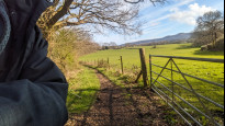
This is a Slow Ways route connecting West Chiltington Common and Steyning.
Know of a better route? Share it here.
This is a Slow Ways route connecting West Chiltington Common and Steyning.
Know of a better route? Share it here.
Status
This route has been reviewed by 1 person.
This route has been flagged (1 times) for reasons relating to access.
Photos for Wesste one


Photos of this route will appear when they are added to a review. You can review this route here.
Information
Route status - Live
Reviews - 1
Average rating -
Is this route good enough? - No (1)
Problems reported - Access (1)
Downloads - 6
Surveys
We are working to build-up a picture of what routes look like. To do that we are asking volunteers to survey routes so that we can communicate features, obstacles and challenges that may make a route desirable or not.
Slow Ways surveyors are asked to complete some basic online training, but they are not vetted. If you are dependent on the survey information being correct in order to complete a route, we recommend that you think critically about the information provided. You may also wish to wait until more than one survey has been completed.
Help people know more about this route by volunteering to submit a survey.
- Complete the survey training.
- Submit a survey for this route.
Geography information system (GIS) data
Total length
Maximum elevation
Minimum elevation
Start and end points
West Chiltington Common
Grid Ref
TQ0841317420
Lat / Lon
50.94603° / -0.45813°
Easting / Northing
508,413E / 117,420N
What3Words
thankful.devoured.volunteered
Steyning
Grid Ref
TQ1754811282
Lat / Lon
50.88907° / -0.33013°
Easting / Northing
517,548E / 111,282N
What3Words
lyrics.ballparks.devalued
Wesste One's land is
| West Chiltington Common | |
|---|---|
| Grid Ref | TQ0841317420 |
| Lat / Lon | 50.94603° / -0.45813° |
| Easting / Northing | 508,413E / 117,420N |
| What3Words | thankful.devoured.volunteered |
| Steyning | |
|---|---|
| Grid Ref | TQ1754811282 |
| Lat / Lon | 50.88907° / -0.33013° |
| Easting / Northing | 517,548E / 111,282N |
| What3Words | lyrics.ballparks.devalued |
| Arable | 38.1% |
| Pasture | 43.0% |
| Urban | 14.6% |
| Woods | 4.3% |
Data: Corine Land Cover (CLC) 2018
review
Srsaunders
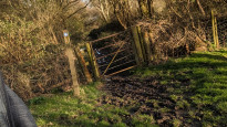
28 Mar 2024This is a long but mostly very nice route. Fields and woods, vineyards, minor stretches on roads and through farms.
Two things let it down:
1) Having to cross the Steyning bypass, which is very very busy and fast. Had to wait a long time then run like crazy to pass through a gap in traffic. Dangerous.
2) One stretch just to the West of the Horsham Rd B2135 at 50°54'46.0"N 0°19'45.6"W Wappingthorn Wood isn't just wet but entirely inundated - essentially a small pond. I had to wade through it up to above my knees to reach the road, and there didn't seem to be any way around, with a barbed wire fence to one side. There's a sign showing it as a public bridleway so it's not a mapping error as such.Perhaps at some times of year it might dry up a bit, but it doesn't look like a sensible route at all as it stands.
The stretch immediately afterwards requires some uncomfortable walking along a fast road for 500m or so.
Maybe there's a way of rerouting the final link into Steyning to avoid both of these issues.Worth doing to save an otherwise very nice route.
(Nevertheless I've rated in 4* as it could be so good!).
Share your views about this route, give it a star rating, indicate whether it should be verified or not.
Include information that will be useful to others considering to walk or wheel it.
You can add up to 15 photos.
Other Routes for West Chiltington Common—Steyning See all Slow Ways
Review this better route and help establish a trusted network of walking routes.
Suggest a better route if it better meets our methodology.
JohnMyerson
30 Mar 2024Kings Barn Lane would be a possible route as it has a bridge across the A283 and is part of cycle network 223. I can't see an easy way round the woods except via Spithandle Lane.
JohnMyerson
30 Mar 2024The other obvious route is to go via Storrington!
JohnMyerson
03 Apr 2024I've added Wesste two to avoid some of your problems. Let me know what you think.
Share your thoughts