Description
This is a Slow Ways route connecting Stevenage and Watton at Stone.
Know of a better route? Share it here.
This is a Slow Ways route connecting Stevenage and Watton at Stone.
Know of a better route? Share it here.
Status
This route has been reviewed by 3 people.
There are no issues flagged.
Photos for Stewat one

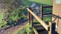
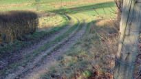


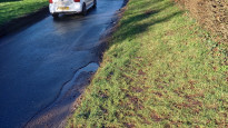


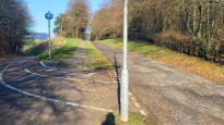


Photos of this route will appear when they are added to a review. You can review this route here.
Information
")
Route status - Live
Reviews - 3
Average rating -
Is this route good enough? - Yes (3)
There are currently no problems reported with this route.
Downloads - 18
Surveys
What is this route like?
Surveys are submitted by fellow users of this website and show what you might expect from this Slow Ways route. Scroll down the page to read more detailed surveys.
| Grade 4X based on 1 surveys | Sign up or log in to survey this route. | ||
|---|---|---|---|
| Description | Note | ||
| Grade 4: Route includes very rough surfaces including deep ruts, steep loose gravel, unmade paths and deep muddy sections. Wheelchairs may experience traction/wheel spin issues. Access grade X: At least one stile, flight of steps or other obstacle that is highly likely to block access for wheelchair and scooter users. |
Grading is based on average scores by surveyors. This slow way has 1 surveys. | ||
| Full grading description | |||
Only people who have completed our training can become Slow Ways surveyors and submit a survey. We do not vet contributors, so we cannot guarantee the quality or completeness of the surveys they complete. If you are dependent on the information being correct we recommend reading and comparing surveys before setting off.
Survey Photos
Facilities
Facilities in the middle third of this route.
Challenges
Potential challenges reported on this route. Some challenges are seasonal.
Obstacles
Obstacles on this route.
Accessibility
Is this route step and stile free?
Measurements
Surveyors were asked to measure the narrowest and steepest parts of paths.
The narrowest part of the path is 60.0cm (1)
The steepest uphill gradient walking East 25.0% (1)
The steepest uphill gradient walking West 25.0% (1)
The steepest camber gradient across the path 5.0% (1)
How clear is the waymarking on the route: Unsigned (1)
Successfully completed
We asked route surveyors "Have you successfully completed this route with any of the following? If so, would you recommend it to someone with the same requirements?". Here is how they replied.
Recommended by an expert
We asked route surveyors "Are you a trained access professional, officer or expert? If so, is this route suitable for someone travelling with any of the following?" Here is how they replied.
Terrain
We asked route surveyors to estimate how much of the route goes through different kinds of terrain.
50.0% of the route is on roads (1)
50.0% of the route is lit at night (1)
50.0% of the route is paved (1)
40.0% of the route is muddy (1)
20.0% of the route is over rough ground (1)
10.0% of the route is through long grass (1)
Report a problem with this data
1 surveys
Information from verified surveys.
Geography information system (GIS) data
Total length
Maximum elevation
Minimum elevation
Start and end points
Stevenage
Grid Ref
TL2348324087
Lat / Lon
51.90166° / -0.20658°
Easting / Northing
523,483E / 224,087N
What3Words
faded.pushed.behind
Watton at Stone
Grid Ref
TL3020919292
Lat / Lon
51.85704° / -0.11068°
Easting / Northing
530,209E / 219,292N
What3Words
fuels.adults.speech
Stewat One's land is
| Stevenage | |
|---|---|
| Grid Ref | TL2348324087 |
| Lat / Lon | 51.90166° / -0.20658° |
| Easting / Northing | 523,483E / 224,087N |
| What3Words | faded.pushed.behind |
| Watton at Stone | |
|---|---|
| Grid Ref | TL3020919292 |
| Lat / Lon | 51.85704° / -0.11068° |
| Easting / Northing | 530,209E / 219,292N |
| What3Words | fuels.adults.speech |
| Arable | 41.5% |
| Other agricultural land | 0.8% |
| Pasture | 6.0% |
| Urban | 51.7% |
| Woods | 0.1% |
Data: Corine Land Cover (CLC) 2018
reviews
Christopher Lewis
05 Mar 2024The route is clear throughout the walk, and the section nearer to Watton-at-Stone is really enjoyable. In Stevenage, the route is still clear but perhaps less enjoyable as much of it passes through residential suburban areas.
Heather S.
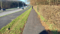
11 Mar 2023A totally fine slow way. a bit long to get out of Stevenage but then you get to fantastic scenic farmland and woodlands all the way to Watton at stone. Road walking on only quiet roads. As there had been rain all week, there were puddles and mud, but all were traversible with minor detours through the wood.
-
Share your thoughts
Strider
21 Jan 2023I walked from Watton at Stone to Stevenage on a sunny but very cold day in January.
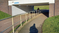
Watton is a pretty village, the walk starts with roadside pavement walking until just past the station where it cuts into a field behind a hedge. Then a farm track along open fields, past a farm and some houses to to Stocking Grove woods. Up to now the mud had been frozen and tarmac-like, in the sheltered woods there was deep mud and puddles. A path better suited to dry summer weather. There is a walk in a road through Raffin Green, but it had some verges and was very quiet. There is a beautiful church at Datchworth. No shops or pub. The walk out of the village is along a verge/ field edge but it is quite a step up to get off the road onto the verge. The views were far and the skies huge. Another farm track down to the railway and under a bridge into Stevenage outskirts. There is a monotonous road for a short while before reaching nice paths alongside cycle paths, no road crossing, lots of underpasses and always slightly away from the traffic makes the pavement walking quite pleasant. The station is through the leisure centre, places to eat near the cinema on the opposite side of the station.
Muddy when wet, I'm glad most was frozen solid when I did the walk, but it will be slippy in the wet.
Not for wheels, narrow verges, big steps and steep (25%) in places.
A good walk, open views and quaint buildings. Some woodlands. Town walking is mostly away from traffic.
-
Share your thoughts
Share your views about this route, give it a star rating, indicate whether it should be verified or not.
Include information that will be useful to others considering to walk or wheel it.
You can add up to 15 photos.
There are no other routes for Stevenage — Watton at Stone
If you know a better way, then please let us know.
Review this better route and help establish a trusted network of walking routes.
Suggest a better route if it better meets our methodology.
Share your thoughts