Description
Updated route between Stanwell Moor and Hounslow which makes use of a green chain of paths following the Duke of Northumberland's River past Heathrow airport.
There is a fair amount of pavement walking as well as the off road paths, but the route is direct and passes close to Heathrow Terminal 4 (which is the only Heathrow terminal with pedestrian access).
There is a spectacular plane watching point across fields south of Hatton Cross.
Crossing the A30 dual carriageway requires patience, but is very doable. There's a break in the central reservation to allow for crossing one side at a time. The nearest traffic lights are to the south at the junction with Stanwell Road
Status
This route has been reviewed by 3 people.
There are no issues flagged.
Photos for Stahou two


Photos of this route will appear when they are added to a review. You can review this route here.
Information
")
Route status - Live
Reviews - 3
Average rating -
Is this route good enough? - Yes (3)
There are currently no problems reported with this route.
Downloads - 2
Surveys
What is this route like?
Surveys are submitted by fellow users of this website and show what you might expect from this Slow Ways route. Scroll down the page to read more detailed surveys.
| Grade 4X based on 1 surveys | Sign up or log in to survey this route. | ||
|---|---|---|---|
| Description | Note | ||
| Grade 4: Route includes very rough surfaces including deep ruts, steep loose gravel, unmade paths and deep muddy sections. Wheelchairs may experience traction/wheel spin issues. Access grade X: At least one stile, flight of steps or other obstacle that is highly likely to block access for wheelchair and scooter users. |
Grading is based on average scores by surveyors. This slow way has 1 surveys. | ||
| Full grading description | |||
Only people who have completed our training can become Slow Ways surveyors and submit a survey. We do not vet contributors, so we cannot guarantee the quality or completeness of the surveys they complete. If you are dependent on the information being correct we recommend reading and comparing surveys before setting off.
Survey Photos
Facilities
Facilities in the middle third of this route.
Challenges
Potential challenges reported on this route. Some challenges are seasonal.
Obstacles
Obstacles on this route.
Accessibility
Is this route step and stile free?
Measurements
Surveyors were asked to measure the narrowest and steepest parts of paths.
The narrowest part of the path is 40.0cm (1)
The steepest uphill gradient walking East 20.0% (1)
The steepest uphill gradient walking West 26.0% (1)
The steepest camber gradient across the path 7.0% (1)
How clear is the waymarking on the route: Unsigned (1)
Successfully completed
We asked route surveyors "Have you successfully completed this route with any of the following? If so, would you recommend it to someone with the same requirements?". Here is how they replied.
Recommended by an expert
We asked route surveyors "Are you a trained access professional, officer or expert? If so, is this route suitable for someone travelling with any of the following?" Here is how they replied.
Terrain
We asked route surveyors to estimate how much of the route goes through different kinds of terrain.
There is no data on how much of this route is on roads
75.0% of the route is lit at night (1)
70.0% of the route is paved (1)
20.0% of the route is muddy (1)
There is no data on rough ground
20.0% of the route is through long grass (1)
Report a problem with this data
1 surveys
Information from verified surveys.
Geography information system (GIS) data
Total length
Maximum elevation
Minimum elevation
Start and end points
Stanwell Moor
Grid Ref
TQ0415174785
Lat / Lon
51.46247° / -0.50215°
Easting / Northing
504,151E / 174,785N
What3Words
scenes.topped.visits
Hounslow
Grid Ref
TQ1351675951
Lat / Lon
51.47115° / -0.36702°
Easting / Northing
513,516E / 175,951N
What3Words
hint.moral.boil
| Stanwell Moor | |
|---|---|
| Grid Ref | TQ0415174785 |
| Lat / Lon | 51.46247° / -0.50215° |
| Easting / Northing | 504,151E / 174,785N |
| What3Words | scenes.topped.visits |
| Hounslow | |
|---|---|
| Grid Ref | TQ1351675951 |
| Lat / Lon | 51.47115° / -0.36702° |
| Easting / Northing | 513,516E / 175,951N |
| What3Words | hint.moral.boil |
Sorry Land Cover data is not currently available for this route. Please check back later.
reviews
Strider
02 Mar 2024I walked from Hounslow to Stanwell Moor.
The first part is along the unattractive Staines Road with little to enjoy which makes the contrast as you walk along The Duke of Northumberland River all the more enjoyable. There had been a lot of rain and the rivers were high, paths were muddy, had large puddles, and in places the river encroached across the path. Nothing insurmountable if wearing good waterproof boots. The path alongside the airport was surprisingly quiet despite the planes being close and the daffodils brought a lot of cheer. Some more roadside and suburban walking takes you to Stanwell Moor.
Probably the best route possible given the geography, and a plane spotters paradise.
Aamwalk
01 May 2023I walked from Stanwell Moor to Hounslow. This is a walk of three different parts just to the south of Heathrow airport. With most on pavements or good paths.
The first is walking through the villages of Stanwell Moor and Stanwell. Just after the start you walk down the quaint Hithermoor Road with the steam running along the front gardens. Later in Stanwell, you go past the church of St Mary the Virgin.
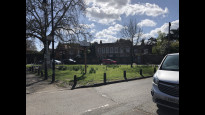
The second stage follows the Duke of Northumberland and Longford rivers and series of green spaces and can feel like little nature oasis with just the sounds of planes. When first joining the river at Stanwell there are two river channels running parallel with a wide embankment in the middle (see picture). You have a choice of which side to walk on. I walked along the central embankment. Before going on the north side from Scylla road. Crossing the A30 was straight forward but you will need to take care. And more difficult with a pushchair.
The path stays to the north of the river and goes through Two bridges Farm green space with lots of wildlife. From here the path regularly swap sides of the river as pass the housing estate and even leaves it for a residential road for one section before going by Hatton Allotments and Dukes Green. There is a large tesco with customer toilets at this point on Faggs Road.
The third stage joins the Staines Road (A315) and you follow this to Hounslow. Though not as nice it gives options of exploring the river crane at Donkey and Brazil mill woods or Hounslow Heath nature reserve. It also well served for buses in to Hounslow town centre if you don’t want to walk this last section.
Overall a good long urban walk.
-
Share your thoughts
Jane Taylor
23 May 2022I walked Stahou One 6 months ago and found it unsatisfactory, so I made this route as an alternative which I find much more pleasant.
From Hounslow head south-west on the Staines Road. The road is long and straight, and it’s not bad to walk along, an urban road with shops and pubs and local traffic. I passed the entrance to Hounslow Heath, but the route doesn’t detour across the heath, it would be quite a swerve to accommodate.
Eventually I reached the junction with the A312 Faggs Road, where I turned right and crossed over the Duke of Northumberland’s river, then left onto a footpath. Now began a lovely run of footpaths which (with a short break) goes all the way past Heathrow to Stanwell.
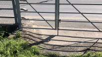
Every now and again a road has to be crossed, mostly this isn’t a problem, but crossing the A30 was more of a challenge. After a little patient wait there was a break in the traffic and I was able to cross safely. (Photo)
At another point the path came out on the roadside up a steep bank (photo) and through a very narrow gap in a hedge (photo).
The route stays on the north side of the DofN’s river past Heathrow T4. It’s a slightly bland, grassed area which has been heavily landscaped, but it doesn’t put the local wildlife off, and I saw a swan and heron on this part of the walk.
Then the route switches to a more rustic path that runs between the DofN’s river and the Longford river. The grass here is not mown, but the path is reasonably clear.
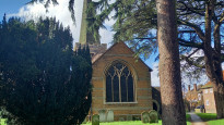
Eventually the route turns away from the two rivers and heads for Stanwell, where there is a classic church and village green, with pub. Stanwell Moor is a bit further on. By the time I reached the endpoint (another pub), I had walked all the way past Heathrow, and was ready to take the next step: to cross the M25 and leave London behind.
I can certainly recommend this route for Slow Ways. It’s probably the Slow Way to choose if walking to Heathrow, from T4 the other terminals can be accessed by free transport.
There are some steps, a short steep section of path, and grassy path walking; otherwise pavement and well surfaced footpath/shared cycleway.
-
Share your thoughts
Share your views about this route, give it a star rating, indicate whether it should be verified or not.
Include information that will be useful to others considering to walk or wheel it.
You can add up to 15 photos.
Other Routes for Stanwell Moor—Hounslow See all Slow Ways
Review this better route and help establish a trusted network of walking routes.
Suggest a better route if it better meets our methodology.
Share your thoughts