Shepherds Bush — Westbourne Park
Shewes one

Verified Slow Way
Verified by 100.00% of reviewers
Verified Slow Way
Verified by 100.00% of reviewers
By a Slow Ways Volunteer on 07 Apr 2021
Description
This is a Slow Ways route connecting Shepherds Bush and Westbourne Park.
Know of a better route? Share it here.
This is a Slow Ways route connecting Shepherds Bush and Westbourne Park.
Know of a better route? Share it here.
Status
This route has been reviewed by 4 people.
There are no issues flagged.
Photos for Shewes one


Photos of this route will appear when they are added to a review. You can review this route here.
Information
Route status - Live
Reviews - 4
Average rating -
Is this route good enough? - Yes (4)
There are currently no problems reported with this route.
Downloads - 4
Surveys
What is this route like?
Surveys are submitted by fellow users of this website and show what you might expect from this Slow Ways route. Scroll down the page to read more detailed surveys.
| Grade 1Y based on 1 surveys | Sign up or log in to survey this route. | ||
|---|---|---|---|
| Description | Note | ||
| Grade 1: Entirely smooth and compacted surfaces. Access grade Y: Stile, step and obstacle free. |
Grading is based on average scores by surveyors. This slow way has 1 surveys. | ||
| Full grading description | |||
Only people who have completed our training can become Slow Ways surveyors and submit a survey. We do not vet contributors, so we cannot guarantee the quality or completeness of the surveys they complete. If you are dependent on the information being correct we recommend reading and comparing surveys before setting off.
Survey Photos
Facilities
Facilities in the middle third of this route.
Challenges
Potential challenges reported on this route. Some challenges are seasonal.
Obstacles
Obstacles on this route.
Accessibility
Is this route step and stile free?
Measurements
Surveyors were asked to measure the narrowest and steepest parts of paths.
Narrowest part of path: no data
The steepest uphill gradient East: no data
The steepest uphill gradient West: no data
The steepest camber: no data
How clear is the waymarking on the route: Very clear (1)
Successfully completed
We asked route surveyors "Have you successfully completed this route with any of the following? If so, would you recommend it to someone with the same requirements?". Here is how they replied.
Recommended by an expert
We asked route surveyors "Are you a trained access professional, officer or expert? If so, is this route suitable for someone travelling with any of the following?" Here is how they replied.
Terrain
We asked route surveyors to estimate how much of the route goes through different kinds of terrain.
100.0% of the route is on roads (1)
100.0% of the route is lit at night (1)
100.0% of the route is paved (1)
There is no data on muddiness
There is no data on rough ground
There is no data on long grass
Report a problem with this data
1 surveys
Information from verified surveys.
Geography information system (GIS) data
Total length
Maximum elevation
Minimum elevation
Start and end points
Shepherds Bush
Grid Ref
TQ2372179902
Lat / Lon
51.50452° / -0.21878°
Easting / Northing
523,721E / 179,902N
What3Words
closed.powers.puppy
Westbourne Park
Grid Ref
TQ2492381782
Lat / Lon
51.52115° / -0.20081°
Easting / Northing
524,923E / 181,782N
What3Words
freed.curl.stored
Shewes One's land is
| Shepherds Bush | |
|---|---|
| Grid Ref | TQ2372179902 |
| Lat / Lon | 51.50452° / -0.21878° |
| Easting / Northing | 523,721E / 179,902N |
| What3Words | closed.powers.puppy |
| Westbourne Park | |
|---|---|
| Grid Ref | TQ2492381782 |
| Lat / Lon | 51.52115° / -0.20081° |
| Easting / Northing | 524,923E / 181,782N |
| What3Words | freed.curl.stored |
| Urban | 100.0% |
Data: Corine Land Cover (CLC) 2018
reviews
Derick Rethans
15 Oct 2022This is a lovely route. When I walked it, I messed up a little and went along Portobello Road — which was a mistake on a Saturday afternoon. I was pleased to see that it was I that had messed up, and the route was spot-on.
Martin McGovern
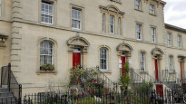
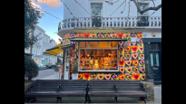
11 Mar 2022A short, wiggly and enjoyable walk through some of London's most expensive streets, juxtaposed with some singularly less costly properties. A nice mix of quirky shops and a good selection of refreshment options. Can be combined with several other neighbouring Slow Ways if you're looking for a longer walk. As has been noted in earlier reviews, the pavements are good, with drop-kerbs at all appropriate locations.
To explain the picture of 'Pottery Lane' - it delighted me as it made a change from streets that are probably named after earls, dukes and the like.
-
Share your thoughts
Jane Taylor
04 Feb 2022Excellent route, direct and easy to follow. Good pavements all the way, no steps.
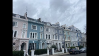
The route passes through Notting Hill and the Portobello Road area, very attractive residential areas, there are some interesting shops and cafes on the way. Well worth the time, a full 5 stars from me.
-
Share your thoughts
Mtormey
04 Jan 2022I walked this route from Shepherds Bush to Westbourne Park. I was extremely pleased with this route, I enjoyed it a lot!
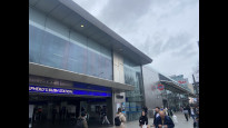
I was worried the navigation around the big roads and junctions at the shopping centre would be complicated to navigate, but it was fairly easy and exactly as mapped.
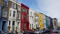
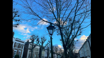
Almost immediately, the route enters a stretch of quiet residential areas. In Notting Hill, many of the homes are painted! It was so lovely and charming.
The last bit of the walk goes through some low traffic streets and more local commercial districts. I popped in a few charity shops on the way and had an overall extremely lovely time.
The route is all on pavements and is fairly typical in that way of the London Slow Ways routes, but it was one of the more charming I’ve ever walked!.
-
Share your thoughts
Share your views about this route, give it a star rating, indicate whether it should be verified or not.
Include information that will be useful to others considering to walk or wheel it.
You can add up to 15 photos.
There are no other routes for Shepherds Bush — Westbourne Park
If you know a better way, then please let us know.
Review this better route and help establish a trusted network of walking routes.
Suggest a better route if it better meets our methodology.
Share your thoughts