Ross-on-Wye — Mitcheldean
Rosmit two

Slow Way not verified yet. Verify Rosmit here.
Slow Way not verified yet. Verify Rosmit here.
By nichowes on 27 Apr 2022
Description
Nic Howes' alternative to Rosmit One, which cannot be used because a short section of it departs from PROWs and access land.
Route Rosmit Two passes through the borderlands between south Herefordshire and the Forest of Dean, geologically, geomorphologically, socially and economically.
There is too much to say in a brief description, so I'll mention some highlights and the fascinating depth can be left to the reference material below.
The route crosses and recrosses the geological "wall" surrounding the Forest of Dean plateau, most clearly marked by dramatic outcrops of Quartz Conglomerate (Photo 2), this area's equivalent of the much better-known Millstone Grit found elsewhere in England. Chase and Penyard Hills are outliers of the Forest of Dean and Wigpool Common is a promontory of it.
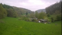
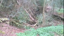
There is much industrial archaeology in this area, including a prospective gold mine, now the site of the Lea Bailey Light Railway. There is also much legacy of iron mining since ancient times, including the strange "delves" and "scowles" excavated into the Crease Limestone in search of pockets of iron ore known locally as "churns". One of these "scowles" has a steep side and a gentle side and was utilised as a makeshift cinema by US service personnel during the build-up to D-Day in WW2 (steep side screen, gentle side tiered seating); this "Yankee Cinema" may still be discerned among the trees northwest of the Wig Pool (Photo 7). In more modern times, Rank Xerox built a huge factory on the outskirts of Mitcheldean, and there is a superb view of town and factory as the route descends from Wigpool Common towards Mitcheldean (Photo 10).
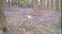
The varied geology has created a wide variety of landscapes, habitats and associated wildlife on a relatively short walk; you can be sure to see much of interest. You are unlikely to meet one face to face, but you may see signs of wild boar in the churned up soil they leave after their rooting for food (Photo 8).
Web links:
Lea Bailey Light Railway: http://www.lblr.fod.uk
Rank Xerox at Mitcheldean: https://xeroxnostalgia.com/2019/07/25/mitcheldean/
Yankee Cinema: http://www.deanforestmiscellany.info/myContents/FODM_YankeeCinema.shtml
Books and guides:
"Explore Ross-on-Wye; Landscape and Geology Trail", Herefordshire and Worcestershire Earth Heritage Trust, 2004
"Geology Explained in the Forest of Dean and Wye Valley", William Dreghorn, 1968, reprinted by Fineleaf Editions, 2005
Nic Howes' alternative to Rosmit One, which cannot be used because a short section of it departs from PROWs and access land.
Route Rosmit Two passes through the borderlands between south Herefordshire and the Forest of Dean, geologically, geomorphologically, socially and economically.
There is too much to say in a brief description, so I'll mention some highlights and the fascinating depth can be left to the reference material below.
The route crosses and recrosses the geological "wall" surrounding the Forest of Dean plateau, most clearly marked by dramatic outcrops of Quartz Conglomerate (Photo 2), this area's equivalent of the much better-known Millstone Grit found elsewhere in England. Chase and Penyard Hills are outliers of the Forest of Dean and Wigpool Common is a promontory of it.
There is much industrial archaeology in this area, including a prospective gold mine, now the site of the Lea Bailey Light Railway. There is also much legacy of iron mining since ancient times, including the strange "delves" and "scowles" excavated into the Crease Limestone in search of pockets of iron ore known locally as "churns". One of these "scowles" has a steep side and a gentle side and was utilised as a makeshift cinema by US service personnel during the build-up to D-Day in WW2 (steep side screen, gentle side tiered seating); this "Yankee Cinema" may still be discerned among the trees northwest of the Wig Pool (Photo 7). In more modern times, Rank Xerox built a huge factory on the outskirts of Mitcheldean, and there is a superb view of town and factory as the route descends from Wigpool Common towards Mitcheldean (Photo 10).
The varied geology has created a wide variety of landscapes, habitats and associated wildlife on a relatively short walk; you can be sure to see much of interest. You are unlikely to meet one face to face, but you may see signs of wild boar in the churned up soil they leave after their rooting for food (Photo 8).
Web links:
Lea Bailey Light Railway: http://www.lblr.fod.uk
Rank Xerox at Mitcheldean: https://xeroxnostalgia.com/2019/07/25/mitcheldean/
Yankee Cinema: http://www.deanforestmiscellany.info/myContents/FODM_YankeeCinema.shtml
Books and guides:
"Explore Ross-on-Wye; Landscape and Geology Trail", Herefordshire and Worcestershire Earth Heritage Trust, 2004
"Geology Explained in the Forest of Dean and Wye Valley", William Dreghorn, 1968, reprinted by Fineleaf Editions, 2005
Status
This route has been reviewed by 1 person.
There are no issues flagged.
Photos for Rosmit two


Photos of this route will appear when they are added to a review. You can review this route here.
Information
Route status - Live
Reviews - 1
Average rating -
Is this route good enough? - Yes (1)
There are currently no problems reported with this route.
Downloads - 1
Surveys
We are working to build-up a picture of what routes look like. To do that we are asking volunteers to survey routes so that we can communicate features, obstacles and challenges that may make a route desirable or not.
Slow Ways surveyors are asked to complete some basic online training, but they are not vetted. If you are dependent on the survey information being correct in order to complete a route, we recommend that you think critically about the information provided. You may also wish to wait until more than one survey has been completed.
Help people know more about this route by volunteering to submit a survey.
- Complete the survey training.
- Submit a survey for this route.
Geography information system (GIS) data
Total length
Maximum elevation
Minimum elevation
Start and end points
Ross-on-Wye
Grid Ref
SO5992024140
Lat / Lon
51.91435° / -2.58411°
Easting / Northing
359,920E / 224,140N
What3Words
scorecard.charging.completed
Mitcheldean
Grid Ref
SO6640418578
Lat / Lon
51.86477° / -2.48930°
Easting / Northing
366,404E / 218,578N
What3Words
unloading.burying.gravest
| Ross-on-Wye | |
|---|---|
| Grid Ref | SO5992024140 |
| Lat / Lon | 51.91435° / -2.58411° |
| Easting / Northing | 359,920E / 224,140N |
| What3Words | scorecard.charging.completed |
| Mitcheldean | |
|---|---|
| Grid Ref | SO6640418578 |
| Lat / Lon | 51.86477° / -2.48930° |
| Easting / Northing | 366,404E / 218,578N |
| What3Words | unloading.burying.gravest |
Sorry Land Cover data is not currently available for this route. Please check back later.
Other Routes for Ross-on-Wye—Mitcheldean See all Slow Ways
Review this better route and help establish a trusted network of walking routes.
Suggest a better route if it better meets our methodology.