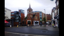
Richmond-upon-Thames — Kingston Vale
Richkin one

Verified Slow Way
Verified by 85.71% of reviewers
Verified Slow Way
Verified by 85.71% of reviewers
By a Slow Ways Volunteer on 07 Apr 2021
Description
This is a Slow Ways route connecting Richmond-upon-Thames and Kingston Vale.
Know of a better route? Share it here.
This is a Slow Ways route connecting Richmond-upon-Thames and Kingston Vale.
Know of a better route? Share it here.
Status
This route has been reviewed by 7 people.
There are no issues flagged.
Photos for Richkin one


Photos of this route will appear when they are added to a review. You can review this route here.
Information
Route status - Live
Reviews - 7
Average rating -
Is this route good enough? - Yes (7)
There are currently no problems reported with this route.
Downloads - 12
Surveys
We are working to build-up a picture of what routes look like. To do that we are asking volunteers to survey routes so that we can communicate features, obstacles and challenges that may make a route desirable or not.
Slow Ways surveyors are asked to complete some basic online training, but they are not vetted. If you are dependent on the survey information being correct in order to complete a route, we recommend that you think critically about the information provided. You may also wish to wait until more than one survey has been completed.
Help people know more about this route by volunteering to submit a survey.
- Complete the survey training.
- Submit a survey for this route.
Geography information system (GIS) data
Total length
Maximum elevation
Minimum elevation
Start and end points
Richmond-upon-Thames
Grid Ref
TQ1805975193
Lat / Lon
51.46341° / -0.30190°
Easting / Northing
518,059E / 175,193N
What3Words
unless.frozen.mugs
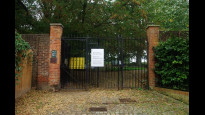
Kingston Vale
Grid Ref
TQ2122572147
Lat / Lon
51.43536° / -0.25739°
Easting / Northing
521,225E / 172,147N
What3Words
basic.lifts.sounds
Richkin One's land is
| Richmond-upon-Thames | |
|---|---|
| Grid Ref | TQ1805975193 |
| Lat / Lon | 51.46341° / -0.30190° |
| Easting / Northing | 518,059E / 175,193N |
| What3Words | unless.frozen.mugs |
| Kingston Vale | |
|---|---|
| Grid Ref | TQ2122572147 |
| Lat / Lon | 51.43536° / -0.25739° |
| Easting / Northing | 521,225E / 172,147N |
| What3Words | basic.lifts.sounds |
| Urban | 100.0% |
Data: Corine Land Cover (CLC) 2018
reviews
JohnMyerson
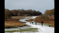
18 Oct 2023Great walk across the park. Closed at night for Deer Cull in October and November, but I saw no deer at all! I left George Street, Richmond by going up Eton Street, then crossed Paradise Road into Vineyard Passage. Quiet pedestrian route passing an interesting graveyard. Then Cambrian Road into the park is almost opposite the end of Marlborough Road. The narrow path ahead is the way to get to the road then down to Pen Ponds on a newly surfaced wide path. There are toilets at Robin Hood Gate but you'll need a bank card to enter (20p).
Ingrina
14 Aug 2023Beautiful, direct route through Richmond Park! We followed this route as it was, but you could take a number of detours as you'd like to explore Richmond Park or follow wider paths if you'd rather not go through too much grass/bracken.
We'd hoped there would be some picnic benches somewhere by Pen Ponds, but it looks like you'd have to get these more around the car park where the kiosk is rather than near the pond.
-
Share your thoughts
Derick Rethans
17 Dec 2022I walked this on a freezy Saturday morning, from Kingston Vale to Richmond.
It is a really lovely route, going through Richmond Park with some hills, great views, and well maintained paths. The ground was frozen with some snow, and in some places at near the finish in Richmond a little slippery, but no problem with decent walking shoes/boots. The section in Richmond itself was really busy, especially near the station as the trains weren't going and there was a long queue for the bus.
This route follows the Capital Ring for some way as well.
I loved it, especially when the sun came out.
-
Share your thoughts
Mtormey
05 Jan 2022I walked this route from Kingston Vale to Richmond on a January morning.
This route was really great. I loved that the route felt like it passed through a lot of different parts of Richmond Park and didn't just follow one "main path" while still being quite direct. Loved getting some views of London, too! The stretch through the residential area and on Richmond High Street were both quite lovely as well.
There was quite a bit of mud in Richmond Park, especially near the entrance by Kingston Vale. I'm sure you could re-route slightly and find a route that avoided much of the mud in particularly wet times.
Overall, I really really enjoyed this route!.
-
Share your thoughts
Jane Taylor
07 Aug 2021Additional review to alert that part of this route across the Pen Ponds Causeway will be closed from 16th August - 4th October 2021 (dates subject to change) while the causeway is raised to cope with 'one in a thousand year' flooding. Maybe there will be a signposted diversion, otherwise refer to maps to steer around the closure, which will involve walking round the ponds.
Still a 5 star route!.
-
Share your thoughts
Jane Taylor
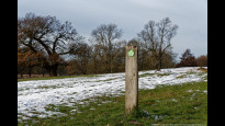
15 Jul 2021Pleasant and direct route from Richmond station across Richmond Park to Kingston Vale. Walk uphill to one of the lesser known park gates, and across the park to Robin Hood Gate and the A3, with opportunities to see fantastic urban wildlife. On this walk I had to detour to avoid red stags on the path, saw two pairs of great crested grebes in the ponds, a small murmuration of starlings and a green woodpecker.
5 stars.
Richmond Park is usually open to pedestrians 24/7 (apart from during the twice yearly deer cull when gates are padlocked after dark) but unlit, so for most people this is going to be a daytime route.
Kingston Vale isn't really a destination as such, it's a connecting point where the longer Richmond - Wimbledon Slow Way crosses the Kingston - Putney Slow Way. The meeting point creates a bit of a dog leg for anyone joining two routes together, and can easily be skipped altogether by crossing the A3 directly outside Robin Hood gate to reach Wimbledon Common, rather than walking to the meeting point, then crossing the A3 by footbridge. However, the meeting point is (almost) at a small arcade of local shops, post office, Italian restaurant, so not without merit for anyone needing a pick-me-up coffee or ice cream.
Accessibility is generally good, no flights of steps. There is a steep rutted hill in the park (picture), and the road leading to/from the park gate at the Richmond end has so much clutter on the pavements there is no way anyone can walk/wheel on them - luckily it's a quiet road.
Road crossings are generally safe, although crossing the A305 at the corner of Sheen Road/Paradise Road needs care as there is no designated pedestrian crossing.
At another point, when crossing the B322 at St Matthias Church the route line doesn't pinpoint the best place to cross, maybe because there isn't one? Take care to ensure good sightlines.
-
Share your thoughts
Philipj8
29 Apr 2021Lovely direct route. Major part of route is through Richmond Park so away from any traffic. Once outside Richmond Park at the Richmond end there is good use of side road which meant that this was an enjoyable walk.
-
Michael Stone
08 May 2021Walking towards Kingston Vale the downhill stretch overlooking Pen Ponds is particularly attractive. Plenty of good onward routes from Kingston Vale across Wimbledon Common. One possible improvement would be to avoid walking through car heavy Richmond centre by using the rear entrance/exit to the station onto Church Road and using that to the point it links up with the suggested route.
-
Share your thoughts
Share your views about this route, give it a star rating, indicate whether it should be verified or not.
Include information that will be useful to others considering to walk or wheel it.
You can add up to 15 photos.
There are no other routes for Richmond-upon-Thames — Kingston Vale
If you know a better way, then please let us know.
Review this better route and help establish a trusted network of walking routes.
Suggest a better route if it better meets our methodology.
Share your thoughts