PutneyWimbledon

Putwim two
Verified route

Verified Slow Way

Verified by 100.00% of reviewers

By Jane Taylor on 28 Nov 2021


Distance

6km/4mi

Ascent

63m

Descent

51m

Download this route

Are you sure you want to download this route?

Using a GPX file for the first time?

No, back to route

Give a hike

Pledge to walk this route and help firm up its place in the network - every walk helps.

So far it has been reviewed by four people and surveyed by one person and

No other people have pledged to review this route.

Your pledged routes will show up in your pledges Waylist.

Every review and survey pledged and then walked will help make the Slow Ways network better, thank you for your help!

Sign up or log in to pledge to walk this route.

Back to route

Save to Waylist

Sign up or log in to save this route so you can find it more easily or plan a longer journey.

More options

Save to my account

Sign up or log in to save this route so you can find it more easily or plan a longer journey.

Print (via Inkatlas)

Survey this route

Review this route

Suggest a better route

Report a problem

Description

Via Putney Green Man, Putney Common, Tippet's Corner, Wimbledon Common and Wimbledon Village.
Plenty of the sort of green spaces this part of London is known for, and a few necessary roads, also reasonably direct.

This route is a rework of Putwim One; it corrects the random drawing on Wimbledon Common, and makes a few other alterations, better to use the commons, and takes a quieter route into/out of Wimbledon.

Can be muddy after rain; a few steps downhill on the way into Wimbledon (or uphill on the way out). Refreshments at Putney Green Man, including a decent roadside takeaway cafe-hut by the buses if you don't fancy the pub (or its too early); and at Wimbledon Village

Status

This route has been reviewed by 4 people.

There are no issues flagged.

Photos for Putwim two

Photos of this route will appear when they are added to a review. You can review this route here.


Information

Verified route

Route status - Live

Reviews - 4

Average rating -

Is this route good enough? -  Yes (4)

There are currently no problems reported with this route.

Downloads - 4

Surveys

What is this route like?

Surveys are submitted by fellow users of this website and show what you might expect from this Slow Ways route. Scroll down the page to read more detailed surveys.

Grade 3X based on 1 surveys Sign up or log in to survey this route.
Description Note
Grade 3: Route includes rough surfaces that may include small boulders, potholes, shallow ruts, loose gravel, short muddy sections.
Access grade X: At least one stile, flight of steps or other obstacle that is highly likely to block access for wheelchair and scooter users.
Grading is based on average scores by surveyors. This slow way has 1 surveys.
Full grading description

Only people who have completed our training can become Slow Ways surveyors and submit a survey. We do not vet contributors, so we cannot guarantee the quality or completeness of the surveys they complete. If you are dependent on the information being correct we recommend reading and comparing surveys before setting off.

Survey Photos

Facilities

Facilities in the middle third of this route.

Not present at time of survey Public toilet (1)
Not present at time of survey Wheelchair accessible toilet (1)
Not present at time of survey Supermarket (1)
Not present at time of survey Restaurant (1)
Not present at time of survey Vegan restaurant (1)
Not present at time of survey Accommodation (1)
Not present at time of survey Accommodation < £50 (1)
Not present at time of survey Campsite (1)
Not present at time of survey Bothy (1)
Not present at time of survey Free wifi (1)
Not present at time of survey Public phone (1)
Not present at time of survey Mobile phone coverage (1)
Not present at time of survey Train station (1)
Not present at time of survey Bench (1)
Not present at time of survey Picnic table (1)
Not present at time of survey Bus stop (1)
Not present at time of survey Ferry (1)

Challenges

Potential challenges reported on this route. Some challenges are seasonal.

Not present at time of survey Scrambling (1)
Not present at time of survey Wading (1)
Not present at time of survey Swimming (1)
Not present at time of survey Climbing (1)
Not present at time of survey Stepping stones (1)
Not present at time of survey Very slippery (1)
Present at time of survey Very muddy (1)
Maybe present Very icy (1)
Not present at time of survey Likely to flood (1)
Not present at time of survey Long grass sections (1)
Not present at time of survey Crops encroaching on path (1)
Not present at time of survey Diverted path (1)

Obstacles

Obstacles on this route.

Not present at time of survey Stiles (1)
Present at time of survey Step and kerbs (1)
Present at time of survey Possible to avoid steps, if applicable (1)
Not present at time of survey Flights of steps (1)
Not present at time of survey Gates (1)
Not present at time of survey Kissing gates (1)
Not present at time of survey Locked gates (1)
Not present at time of survey Disables access gates (1)
Not present at time of survey Cycle barriers (1)
Not present at time of survey Ladders (1)
Not present at time of survey Cattle grids (1)
Not present at time of survey Fords (1)
Not present at time of survey Narrow bridges (1)
Not present at time of survey Ferry required (1)
Not present at time of survey Acceptable road walking (1)
Not present at time of survey Unacceptable road walking (1)
Not present at time of survey Dangerous road crossings (1)
Present at time of survey Walking on paths beside roads (1)
Not present at time of survey Walking on verges beside roads (1)
Not present at time of survey Railway crossings (1)
Not present at time of survey River crossings (1)
Not present at time of survey Cattle possible (1)
Present at time of survey Horses possible (1)
Not present at time of survey Tidal area (1)
Not present at time of survey Potential falls (1)
Not present at time of survey Exposed to elements (1)
Not present at time of survey Remote area (1)
Not present at time of survey Mountainous area (1)
Not present at time of survey Military training area (1)
Not present at time of survey No visible path (1)
Not present at time of survey Seasonal nesting birds (1)
Not present at time of survey Other hazards (1)

Accessibility

Is this route step and stile free?

Present at time of survey Free of stiles (1)
Not present at time of survey Free of single steps/kerbs (1)
Present at time of survey Free of flights of steps (1)
Present at time of survey Free of other obstacles (1)

Measurements

Surveyors were asked to measure the narrowest and steepest parts of paths.

The narrowest part of the path is 100.0cm (1)

The steepest uphill gradient walking East 7.0% (1)

The steepest uphill gradient walking West 6.0% (1)

The steepest camber gradient across the path 1.0% (1)

How clear is the waymarking on the route: Unsigned (1)

Successfully completed

We asked route surveyors "Have you successfully completed this route with any of the following? If so, would you recommend it to someone with the same requirements?". Here is how they replied.

Small Pug-sized dog (0)
Small Labrador-sized dog (0)
Large St. Bernard-sized dog (0)
Standard pram (0)
Off-road rugged pram (0)
Standard wheelchair (0)
Off-road rugged wheelchair (0)
Standard mobility scooter (0)
Off-road rugged mobility scooter (0)

Recommended by an expert

We asked route surveyors "Are you a trained access professional, officer or expert? If so, is this route suitable for someone travelling with any of the following?" Here is how they replied.

Small Pug-sized dog (0)
Small Labrador-sized dog (0)
Large St. Bernard-sized dog (0)
Standard pram (0)
Off-road rugged pram (0)
Standard wheelchair (0)
Off-road rugged wheelchair (0)
Standard mobility scooter (0)
Off-road rugged mobility scooter (0)

Terrain

We asked route surveyors to estimate how much of the route goes through different kinds of terrain.

60.0% of the route is on roads (1)

60.0% of the route is lit at night (1)

60.0% of the route is paved (1)

30.0% of the route is muddy (1)

2.0% of the route is over rough ground (1)

1.0% of the route is through long grass (1)

Report a problem with this data

1 surveys

Information from verified surveys.

3X June 2024 by Strider
Read survey

Sign up or log in to get the link to survey this route for Putwim.

Geography information system (GIS) data

Total length

Maximum elevation

Minimum elevation

Start and end points

Putney
Grid Ref TQ2398075091
Lat / Lon 51.46122° / -0.21674°
Easting / Northing 523,980E / 175,091N
What3Words factories.whips.slave
Wimbledon
Grid Ref TQ2477170654
Lat / Lon 51.42117° / -0.20692°
Easting / Northing 524,771E / 170,654N
What3Words swung.reap.park

Sorry Land Cover data is not currently available for this route. Please check back later.

reviews


Strider

10 May 2024 Spring

I walked from Putney to Wimbledon.
The beginning is a monotonous Road but past the bus yard it gets into lovely woodland. Cool shade on this hot day but still mud and deep puddles out of the sun.
More roads to end with. What a contrast Putney and Wimbledon streets are.
Good route, direct, easy to navigate. If the muddy paths dry firm and flat it will be okay for chairs and buggies.


Derick Rethans

10 Dec 2023 Autumn

I walked this on an afternoon, it had rained in the morning, from Putney to Wimbledon.

The first section is a bit of a slog up the hill, although the traffic was light. After rounding the Putney Heath bus station (snack bar!), and going underneath the roundabout, the route becomes more pleasant. The sections through the woods were nice (photo #1, #2, #3), but it was all fairly muddy. I think it's fairly easy to find a less muddy, but slightly longer, route, following the main path. There was virtually nobody else around.

The section through Wimbledon Village was alright, and full of Christmas markets and choppers. Then it leaves Wimbledon High Road for a bit, but I don't think that improved the route — except that there were no people.

A good route though, but probably much nicer in summer.


JohnMyerson

11 Aug 2023 Summer

I actually started at Westleigh Avenue (off Putney Hill) as I'd come from Richmond. The café at Putney Heath was useful (toilet there too (20p)). Once on Wimbledon Common I followed the obvious main path, which ends up near the windmill (café and toilets), and then the broad cycle path towards Rushmere Pond and Wimbledon Village. Slightly longer than walking next to the main road, but much more pleasant. Lingfield Road avoids the High Street then Oldfield Road leads into Sunnyside Passage and Malcolm Road.


Jane Taylor

05 Dec 2021 Autumn

This route has a good balance of directness/pleasantness - it swerves a bit to take in Wimbledon and Putney Commons but it's well worth the swerve, a more direct route would be pavement walk all the way.

Putney Hill is always busy with traffic and there really isn't an alternative. At the top of the hill there is the Green Man (pub, but I prefer the roadside cabin cafe by the bus terminus, see photo), and the route arrives at Putney Common, where it follows a path (may be wet) to the A3 underpass at Tippet's Corner.
Across Putney and Wimbledon commons is mostly woodland bridle path, and can get muddy (photo).
I arrived at Wimbledon village in time for a farmers' market (Sunday morning).
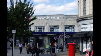
After passing through the village, the route diverts away from the main road, and follows quiet residential streets down a steep hill (some steps) to the meeting point at Wimbledon station.

Verdict - excellent route connecting two major urban centres in SW London, highly recommended.


Share your views about this route, give it a star rating, indicate whether it should be verified or not.

Include information that will be useful to others considering to walk or wheel it.

You can add up to 15 photos.

Overall ratings

4 reviews


1 reviews

3 reviews

0 reviews

0 reviews

0 reviews

Show all


Other Routes for Putney—Wimbledon See all Slow Ways

Putney—Wimbledon

Putwim one

Distance

6km/3mi

Ascent

56 m

Descent

44 m

Review this better route and help establish a trusted network of walking routes.

Suggest a better route if it better meets our methodology.

See all routes from Putney.

See all routes from Wimbledon.