Princes Risborough — High Wycombe
Prihig one

Verified Slow Way
Verified by 100.00% of reviewers
Verified Slow Way
Verified by 100.00% of reviewers
By a Slow Ways Volunteer on 07 Apr 2021
Description
This is a Slow Ways route connecting Princes Risborough and High Wycombe.
Know of a better route? Share it here.
This is a Slow Ways route connecting Princes Risborough and High Wycombe.
Know of a better route? Share it here.
Status
This route has been reviewed by 4 people.
There are no issues flagged.
Photos for Prihig one


Photos of this route will appear when they are added to a review. You can review this route here.
Information
Route status - Live
Reviews - 4
Average rating -
Is this route good enough? - Yes (4)
There are currently no problems reported with this route.
Downloads - 9
Surveys
We are working to build-up a picture of what routes look like. To do that we are asking volunteers to survey routes so that we can communicate features, obstacles and challenges that may make a route desirable or not.
Slow Ways surveyors are asked to complete some basic online training, but they are not vetted. If you are dependent on the survey information being correct in order to complete a route, we recommend that you think critically about the information provided. You may also wish to wait until more than one survey has been completed.
Help people know more about this route by volunteering to submit a survey.
- Complete the survey training.
- Submit a survey for this route.
Geography information system (GIS) data
Total length
Maximum elevation
Minimum elevation
Start and end points
Princes Risborough
Grid Ref
SP8074503497
Lat / Lon
51.72439° / -0.83238°
Easting / Northing
480,745E / 203,497N
What3Words
hourglass.leaky.windy
High Wycombe
Grid Ref
SU8691693052
Lat / Lon
51.62958° / -0.74566°
Easting / Northing
486,916E / 193,052N
What3Words
invite.debate.crass
Prihig One's land is
| Princes Risborough | |
|---|---|
| Grid Ref | SP8074503497 |
| Lat / Lon | 51.72439° / -0.83238° |
| Easting / Northing | 480,745E / 203,497N |
| What3Words | hourglass.leaky.windy |
| High Wycombe | |
|---|---|
| Grid Ref | SU8691693052 |
| Lat / Lon | 51.62958° / -0.74566° |
| Easting / Northing | 486,916E / 193,052N |
| What3Words | invite.debate.crass |
| Arable | 18.6% |
| Pasture | 20.5% |
| Urban | 36.2% |
| Woods | 24.7% |
Data: Corine Land Cover (CLC) 2018
reviews
Derick Rethans
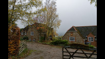
13 Nov 2022I walked this from Princess Risborough to High Wycombe on a warmish autumn morning, which was a little foggy (As the photos show).
It was a delightful route. It hadn't rained a lot in the past week, but it was still a little muddy in some places.
From Princess Risborough you quickly end up on lovely paths at field edges, with red kites circling above. It's a little up-and-downy. At Loosley Row there is a lovely set of farm houses, and then there is a stretch of road walking, albeit not very long and with a reasonable pavement. It goes up from here on. Near Lacey Green there were some cows in the field, but they ignored me. They were quite far away. After a few stretches through some more fields (without animals), the route continues through wooded lanes and along the edges of fields with crops. At one point there was a bunch of guys shooting grouse/pheasants, with their dogs fetching the fallen birds. The colours of the trees were awesome here. Bradenham Wood was gorgeous again, although I did get a little bit lost as the paths were hard to see due to all the leaves! The village of Saunderton looked very picturesque from the hill side. There is a shortcut at Bradenham's church, and you don't have to do the silly dogleg, although you can. From there on there are more wooded paths, and you go up again towards Hughenden Manor. From there it is a pleasant walk down the hill through the park, to end up besides the road going past lots of new developments. From there on it is a short stretch towards High Wycombe besides roads with pavemements.
Ianschagen
27 May 2021The route was pretty well mapped and mostly easy, apart from a large amount of mud in the woods at Knaphill Common, which required a lot of detouring. The first section, across fields, is easy and scenic. Uphill on the road to Lacey Green is less so. After Lacy Green we encountered some mad cows in a field, one of whom chased us rather assertively. The do-leg at Bradenham could be shortened by walking across the green in front of the church, unless you want to go to the Red Lion pub by the main road.
Several coffee shops in Princes Risborough (including Crumbs Too), and café in Hughenden Manor stableyard. Red Lion pub at Bradenham is open Tuesday to Sunday, 10.00 to 4.30.
-
Share your thoughts
QuercusXHispanica
03 May 2021A great route through beautiful scenery and passing by Bradenham Manor and Hughenden Manor (both of which were home to Benjamin Disraeli).
The section from Princes Risborough to Bradenham Woods car park goes through rolling hills with sweeping views but does contain some stiles that might present an obstacle to the less mobile (there is a list of obstacles at the end of this review). While walking this section we also walked through a field that had cows in it (although we didn't bother them, and they didn't bother us). After this, there is a bit of a detour via the Red Lion at Bradenham, which you could cut short if you were not in need of refreshment. The section through Naphill and Downley common is best navigated with the aid of mapping software, unless you have a really good sense of direction.
Obstacles (latitude, longitude).
Stiles at:
51.7105217,-0.823783
51.7099876,-0.823285 (This one is particularly tricky because it is missing a step!)
51.7099762,-0.823327
51.7065773,-0.821195
51.7056885,-0.820630
51.694023, -0.813000
51.6935043,-0.811822
Field with cows at 51.6934814,-0.811935.
-
Share your thoughts
Share your views about this route, give it a star rating, indicate whether it should be verified or not.
Include information that will be useful to others considering to walk or wheel it.
You can add up to 15 photos.
There are no other routes for Princes Risborough — High Wycombe
If you know a better way, then please let us know.
Review this better route and help establish a trusted network of walking routes.
Suggest a better route if it better meets our methodology.
Share your thoughts