Description
I replotted this route at home to try and make the walk through Nelson more interesting
I replotted this route at home to try and make the walk through Nelson more interesting
Status
This route has been reviewed by 1 person.
There are no issues flagged.
Photos for Nelcol two


Photos of this route will appear when they are added to a review. You can review this route here.
Information

Route status - Live
Reviews - 1
Average rating -
Is this route good enough? - Yes (1)
There are currently no problems reported with this route.
Downloads - 1
Surveys
What is this route like?
Surveys are submitted by fellow users of this website and show what you might expect from this Slow Ways route. Scroll down the page to read more detailed surveys.
| Grade 4X based on 1 surveys | Sign up or log in to survey this route. | ||
|---|---|---|---|
| Description | Note | ||
| Grade 4: Route includes very rough surfaces including deep ruts, steep loose gravel, unmade paths and deep muddy sections. Wheelchairs may experience traction/wheel spin issues. Access grade X: At least one stile, flight of steps or other obstacle that is highly likely to block access for wheelchair and scooter users. |
Grading is based on average scores by surveyors. This slow way has 1 surveys. | ||
| Full grading description | |||
Only people who have completed our training can become Slow Ways surveyors and submit a survey. We do not vet contributors, so we cannot guarantee the quality or completeness of the surveys they complete. If you are dependent on the information being correct we recommend reading and comparing surveys before setting off.
Survey Photos
Facilities
Facilities in the middle third of this route.
Challenges
Potential challenges reported on this route. Some challenges are seasonal.
Obstacles
Obstacles on this route.
Accessibility
Is this route step and stile free?
Measurements
Surveyors were asked to measure the narrowest and steepest parts of paths.
The narrowest part of the path is 15.0cm (1)
The steepest uphill gradient walking East 18.0% (1)
The steepest uphill gradient walking West 18.0% (1)
The steepest camber gradient across the path 5.0% (1)
How clear is the waymarking on the route: Unclear (1)
Successfully completed
We asked route surveyors "Have you successfully completed this route with any of the following? If so, would you recommend it to someone with the same requirements?". Here is how they replied.
Recommended by an expert
We asked route surveyors "Are you a trained access professional, officer or expert? If so, is this route suitable for someone travelling with any of the following?" Here is how they replied.
Terrain
We asked route surveyors to estimate how much of the route goes through different kinds of terrain.
6.0% of the route is on roads (1)
40.0% of the route is lit at night (1)
50.0% of the route is paved (1)
5.0% of the route is muddy (1)
25.0% of the route is over rough ground (1)
25.0% of the route is through long grass (1)
Report a problem with this data
1 surveys
Information from verified surveys.
Geography information system (GIS) data
Total length
Maximum elevation
Minimum elevation
Start and end points
Nelson
Grid Ref
SD8601037686
Lat / Lon
53.83525° / -2.21407°
Easting / Northing
386,010E / 437,686N
What3Words
pencils.unimpeded.tries
Colne
Grid Ref
SD8919040140
Lat / Lon
53.85738° / -2.16583°
Easting / Northing
389,190E / 440,140N
What3Words
keep.penny.bookings
| Nelson | |
|---|---|
| Grid Ref | SD8601037686 |
| Lat / Lon | 53.83525° / -2.21407° |
| Easting / Northing | 386,010E / 437,686N |
| What3Words | pencils.unimpeded.tries |
| Colne | |
|---|---|
| Grid Ref | SD8919040140 |
| Lat / Lon | 53.85738° / -2.16583° |
| Easting / Northing | 389,190E / 440,140N |
| What3Words | keep.penny.bookings |
Sorry Land Cover data is not currently available for this route. Please check back later.
review
Mary Oz
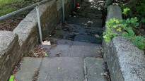
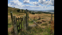
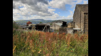
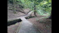
06 Aug 2022The route left Colne downhill to cross Colne Water near the Admiral Lord Rodney pub. NelCol One suggests cutting the corner of the bendy downhill road, but the cut-through (between bollards) was cobbled and steep and overhung by trees, so I suspect it would by very slippery at times. Instead, I cut down a set of steps a bit earlier. Once over the river the OS marked footpath looked as if it could be blocked by factory gates, and also it crossed rough concreted industrial land, so I changed the route to go around the industrial buildings. The access to the fields was okay, but there were some threatening dogs which were (fortunately) kept behind fences. There was a field crossing with steps at either end, and the dogs continued to chase along the fence, barking.
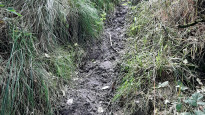
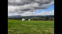
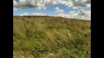
The path climbed steeply over fairly rough land but it did look well used. It arrived by a small pond, which I needed to keep to the east of. I crossed a quiet road into the next field. This is described as Tum Hill Recreation Ground. There were signs of footpaths across it, but in August it was rather wild with long grass, and I found it quite hard going, especially the second field. However there were excellent views from up here! This area also includes the remains of Castercliff Hill Fort. At the right time of year, it could be fabulous, but for me, I was glad to reach Little Gib Hill, and a more obvious footpath down to the edge of the golf course and the outskirts of Nelson.
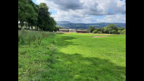
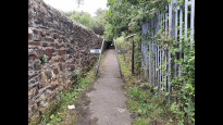
Marsden Park was very nice, with a multitude of paths to choose from. At the north east corner is the Marsden Old Hall Café (open 4 days a week). I’ve since found out that I missed visiting the Icosahedral Sundial!
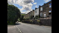
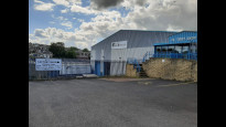
Soon after the park was an alleyway with cycle barriers. After this, the housing roads led to the Farmhouse Biscuits Factory Shop (toilets but no café) where I spent some time! It was only a short walk from there to Nelson Station.
Share your views about this route, give it a star rating, indicate whether it should be verified or not.
Include information that will be useful to others considering to walk or wheel it.
You can add up to 15 photos.
Other Routes for Nelson—Colne See all Slow Ways
Review this better route and help establish a trusted network of walking routes.
Suggest a better route if it better meets our methodology.
Share your thoughts