Description
This is a Slow Ways route connecting Ledbury and Newent.
Know of a better route? Share it here.
This is a Slow Ways route connecting Ledbury and Newent.
Know of a better route? Share it here.
Status
This route has been reviewed by 1 person.
There are no issues flagged.
Photos for Lednew one


Photos of this route will appear when they are added to a review. You can review this route here.
Information

Route status - Live
Reviews - 1
Average rating -
Is this route good enough? - Yes (1)
There are currently no problems reported with this route.
Downloads - 8
Surveys
We are working to build-up a picture of what routes look like. To do that we are asking volunteers to survey routes so that we can communicate features, obstacles and challenges that may make a route desirable or not.
Slow Ways surveyors are asked to complete some basic online training, but they are not vetted. If you are dependent on the survey information being correct in order to complete a route, we recommend that you think critically about the information provided. You may also wish to wait until more than one survey has been completed.
Help people know more about this route by volunteering to submit a survey.
- Complete the survey training.
- Submit a survey for this route.
Geography information system (GIS) data
Total length
Maximum elevation
Minimum elevation
Start and end points
Ledbury
Grid Ref
SO7109737711
Lat / Lon
52.03705° / -2.42276°
Easting / Northing
371,097E / 237,711N
What3Words
cries.wool.eyelash
Newent
Grid Ref
SO7226125820
Lat / Lon
51.93020° / -2.40483°
Easting / Northing
372,261E / 225,820N
What3Words
clays.cone.lots
Lednew One's land is
| Ledbury | |
|---|---|
| Grid Ref | SO7109737711 |
| Lat / Lon | 52.03705° / -2.42276° |
| Easting / Northing | 371,097E / 237,711N |
| What3Words | cries.wool.eyelash |
| Newent | |
|---|---|
| Grid Ref | SO7226125820 |
| Lat / Lon | 51.93020° / -2.40483° |
| Easting / Northing | 372,261E / 225,820N |
| What3Words | clays.cone.lots |
| Arable | 73.7% |
| Other agricultural land | 3.0% |
| Pasture | 7.2% |
| Urban | 16.1% |
Data: Corine Land Cover (CLC) 2018
review
Nichowes
18 Sep 2022 (edited 23 Sep 2022)Nic Howes walked this route 17.9.22. I drove from home to Newent with my bicycle on a roof rack, parked the car and cycled to Ledbury, locked the bike there and started trialling the route, Tweeting as I went.
It's a great walk, full of interest. I knocked a star off because the route is not easy to follow on the ground, due to walker-unfriendly land management on a significant proportion of it and also it rarely escapes the sound of road traffic.
The Slow Ways volunteer who plotted the route on 17.04.21 did a great job incorporating places of interest and included Three Shires Garden Centre. Visiting the latter adds on distance and a long section of road walking, including alongside the fast, dangerous B4215, locals' preferred direct vehicle route from Hereford to Gloucester. I trialled the route nearly as far as the B4215 but then turned back and took a shortcut along the calmer, quieter Geopark Way. For the benefit of walkers who wish to follow this non-road shortcut, I will post it as Lednew two.
Starting at the Market House (centre of Photo 1) the walk passes the Corner House Cafe (refreshment stop for me) and follows quiet residential streets out of Ledbury, passing John Masefield High School on the way (Photo 2), named after a famous former resident of the town.
After crossing the bypass, the security fencing around the fields on the right appeared to indicate that this land on Ledbury's rural-urban fringe has been earmarked for development; later, a quick area search on the planning portal revealed this to be the case "...up to 140 residential dwellings..." (Photo 3, with briony in the hedge and the Woolhope Dome on the horizon).
The loss of the footbridge on the line of the PROW over the next brook is the first of many minor difficulties that I have referred to earlier as "walker-unfriendly land management". Rather than describe every one of these minor difficulties I will say that Lednew is best followed with the aid of GPS to keep walkers on track; walkers using just a paper map will need to be extremely well-versed in navigating across intensively managed farmland, including compass work to sight path direction across large fields with no waymarks.
Looking up into the blue sky, the contrails evidenced the continuing passenger jet flights (Photo 4) and I reflected that I would be most unlikely to ever be up there myself again, fortunate to find enough wonders to satisfy my curiosity in the UK, and not having family living abroad. I could also see the moon, a visit definitely not on my bucket list (not that I have one).
There was some early autumn colour emerging alongside the drive to Nurdens Farm (Photo 5). Further on, overlooking the footpath, this old clay pantile roof was irresistible for Photo 6. The interestingly named village of Redmarley D'Abitot lies about 3 miles southwest; Red Marley is a brand name for modern pantiles, but I have yet to find confirmation that pantiles were once made round here. There are then glimpses of Donnington Hall across the fields to the right, British Listed Buildings says: Country house. Mid-C18, extensively remodelled and enlarged in 1909 by an
architect called Ogilvy (Pevsner) for Admiral Fanshawe.
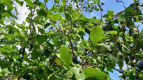
Broom's Green is a pretty hamlet, which used to have a nice little pub - The Horseshoe Inn - which closed in 2001 and now includes s/c accommodation in an annexe (https://www.horseshoeinnhouse.com). A Catalpa (aka Indian Bean Tree - Photo 7) drew my attention on the right, after passing Horseshoe Inn House. Starting down the Poets Path 2 from Broom's Green I noticed fruit (wild damsons, I think) overhead, another sign of early autumn (Photo 8).
Soon after the fruit tree, I spotted an overgrown sign that heralded access to well-managed, walker-friendly land that I knew was in this area, but had not expected to cross on Lednew - that of Charles Martell and Son (Photo 9). I first came across Charles on the first broadcast of Episode 6 of the long-lost BBC TV "Talking Landscapes" series; he demonstrates animal-drawn ploughing to presenter Aubrey Manning. The series is not available to view (https://www.bbc.co.uk/programmes/b00mrtct/episodes/guide) but I did find a transcript online: https://subsaga.com/bbc/science/talking-landscapes/6-the-vale-of-evesham.html
The section through the Martells' land demonstrates their "commitment to minimising the impact of our activities on the environment to as low a level as is practically and economically feasible, while promoting sustainability": https://www.charlesmartell.com/farm/environment/ You will see good access arrangements, well-kept livestock (Photo 10), beautiful dense, high hedges with hedgerow trees and a wealth of wildlife (e.g. hedgerow Hawthorn berries, Photo 11). This SlowWays reviewer is keen to play a part in drawing attention to, promoting and encouraging sustainable farming practices such as the Martells'.
A little further on, a striking newly built property comes into view on the right; few details appear online, and it does not appear on the OS map, although Google Maps satellite view shows it to be ‘S’-shaped in plan form (Photo 12).
Poets’ Path No 2 continues away from the Martells’ land, through Knight’s Green and southwards onto a footbridge, beyond which there was a rolled footpath through a large corn field that had grown to above head height. Beyond Elm Bridge there is a choice of Poets’ Paths to follow into Dymock; Lednew one follows Poets’ Path No 1 along the edge of the floodplain of the River Leadon to turn left along the B4216. It’s worth turning off the road to the right to arrive in Dymock via the churchyard; the church contains interpretation that explains the association with the Dymock Poets, including Edward Thomas, who wrote “Adlestrop” after stopping at that station on his rail journey from London to Dymock, via Gloucester, in June 1914. The village pub is the nearby Beauchamp Arms.
The Daffodil Way leads south from Dymock to the old bridge that carries the drive to Boyce Court over the line of the Herefordshire and Gloucestershire canal: https://www.h-g-canal.org.uk Turning off the Daffodil Way at this point Lednew one begins to follow the towpath near a point where a concrete dam holds back water in a section the canal (Photo 13). The towpath leads to the northern portal of the Oxenhall Tunnel, which has suffered a catastrophic collapse and is now hard to access and identify. Walkers might enjoy this upbeat (but annoyingly sponsored) video about this and two other tunnels on the H&G: https://www.h-g-canal.org.uk/wordpress/canal-tunnel-exploration/ Alternatively, Urbexers (Rurexers?) might enjoy this more hard-edged exploration; at the time it was made in March 2015, Oxenhall tunnel was navigable from the southern portal for 80% of its length: https://www.28dayslater.co.uk/threads/oxenhall-tunnel-march-2015.95250/
Shortly beyond the northern portal Lednew one passes under the M50 motorway in a little-used pedestrian underpass. The route then runs parallel to the M50, past the abandoned farm buildings at Farrs and continues south to Hillend Green.
Lednew one now continues eastwards to meet the B4215, presumably to include the possibility of a visit to Three Shires Garden Centre. This would involve walking more than half a mile alongside a busy road before turning right along the lane towards Oxenhall. This road walking can be avoided with a short cut that is described in my review of Lednew two.
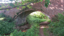
Lednew one merges with Lednew two on a sharp bend in Coldharbour Lane, near a white house. The route now follows the Geopark Way down the lane to another canal bridge, where the towpath is accessed through a gate on the right, before walking under the bridge (Photo 14, looking back). The towpath is well maintained by local volunteers and leads to a road crossing and then along a canalside drive to the delightfully restored Oxenhall Lock (Photo 15).
From Oxenhall Lock Lednew one leads along the canal route towards the restored brick and stone parapet of an aqueduct before meeting Horsefair Lane, along which the route turns left into Newent.
Share your views about this route, give it a star rating, indicate whether it should be verified or not.
Include information that will be useful to others considering to walk or wheel it.
You can add up to 15 photos.
Other Routes for Ledbury—Newent See all Slow Ways
Review this better route and help establish a trusted network of walking routes.
Suggest a better route if it better meets our methodology.
Share your thoughts