Kibblesworth — Gateshead
Kibgat one

Slow Way not verified yet. Verify Kibgat here.
Slow Way not verified yet. Verify Kibgat here.
By a Slow Ways Volunteer on 07 Apr 2021
Description
This is a Slow Ways route connecting Kibblesworth and Gateshead.
Know of a better route? Share it here.
This is a Slow Ways route connecting Kibblesworth and Gateshead.
Know of a better route? Share it here.
Status
This route has been reviewed by 2 people.
This route has been flagged (2 times) for reasons relating to safety.
Photos for Kibgat one


Photos of this route will appear when they are added to a review. You can review this route here.
Information
Route status - Live
Reviews - 2
Average rating -
Is this route good enough? - Maybe (2)
Problems reported - Safety (2)
Downloads - 3
Surveys
We are working to build-up a picture of what routes look like. To do that we are asking volunteers to survey routes so that we can communicate features, obstacles and challenges that may make a route desirable or not.
Slow Ways surveyors are asked to complete some basic online training, but they are not vetted. If you are dependent on the survey information being correct in order to complete a route, we recommend that you think critically about the information provided. You may also wish to wait until more than one survey has been completed.
Help people know more about this route by volunteering to submit a survey.
- Complete the survey training.
- Submit a survey for this route.
Geography information system (GIS) data
Total length
Maximum elevation
Minimum elevation
Start and end points
Kibblesworth
Grid Ref
NZ2454956766
Lat / Lon
54.90502° / -1.61869°
Easting / Northing
424,549E / 556,766N
What3Words
chariots.saving.vans
Gateshead
Grid Ref
NZ2548763069
Lat / Lon
54.96161° / -1.60350°
Easting / Northing
425,487E / 563,069N
What3Words
arrow.making.snaps
Kibgat One's land is
| Kibblesworth | |
|---|---|
| Grid Ref | NZ2454956766 |
| Lat / Lon | 54.90502° / -1.61869° |
| Easting / Northing | 424,549E / 556,766N |
| What3Words | chariots.saving.vans |
| Gateshead | |
|---|---|
| Grid Ref | NZ2548763069 |
| Lat / Lon | 54.96161° / -1.60350° |
| Easting / Northing | 425,487E / 563,069N |
| What3Words | arrow.making.snaps |
| Arable | 36.1% |
| Pasture | 6.0% |
| Urban | 54.3% |
| Woods | 3.6% |
Data: Corine Land Cover (CLC) 2018
reviews
Andy Redfern
09 Apr 2023This is a good start for a route from Gateshead to Kibblesworth, but it has a few flaws that make it too dangerous to be used without being updated. My comments largely echo what the previous reviewer concluded.
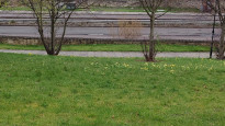
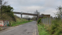
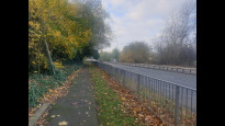
The route starts at Gateshead Interchange - so no problem getting to the start by public transport. The route out of Gateshead quickly get into grass and trees by going through Windmill Hills park. Definitely worth taking the 100 yard detour to the summit of the hill where the old windmill stood for a great view over Newcastle on the other side of the Tyne. The route heads down to the A184 dual carriageway. As there is no safe place to cross, stay on the higher path and use the foot bridge opposite the bottom of the tower block.
Once over the bridge head back to the route and drop down in to Gateshead Riverside park. The route is easy to follow and paved all the way. A dog leg at the Autumn drive traffic lights is a safe crossing place and then the route follows an old waggonway through to Ropery Road.
Crossing Derwentwater Road requires care but the underpass takes you under the A184 safely. The route then follows the main road as it joins the A1. The suggested route across Lobley Hill road is too dangerous during business hours and I would recommend using the pair of underpasses and the bridge to you at the start of the Coach road.
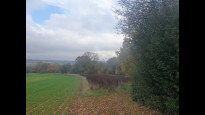
The section along the Coach Road is easy to follow but does require a cautious approach as it is narrow in some places and has a 60mph speed limit. It is used by cyclists and so hopefully motorists are learning to take a cautious approach too.
As you approach Lady Park the official route follows a short path up to Banesley Lane and then through to Ouslaw Lane. As someone who lives locally I would not recommend this route. The roads are narrow, have no footpath and serve as an alternative traffic "rat run" at busier due to traffic in Lobley Hill.
A much better route as noted by the previous reviewer is to head on through Lady Park and follow Banesley Lane towards the A1 junction. There is a short public footpath from Banesley Lane to Lamesley Road which saves cross the road at the busy Coalhouse Roundabout. However on my walk the farmer had secured the gate mechanism with a piece of barbed wire that I could not remove, so walked the slightly longer route round.
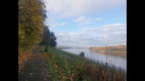
You then follow the road on a footpath round to the Ravensworth Arms pub. If you go through the pub car park, there is an entrance to the new Lamesley Pastures Nature Reserve. This has a path along its perimeter that follows the road that offers much better views than the footpath on the road. However, being flood pastures be prepared to get wet or reroute back the road!
The final stretch into Kibblesworth is on a well made up footpath into the village.
So the key problems are:
* crossing the A184 - use the footbridge 200 yards further alonng
* crossing the B1426 Lobley Hill Road - use the underpass, the footbridge and the other underpass to join the Coach Road
* the whole section from Banesley Lane to Ouslaw Lane - reroute via Lady Park and Lamesley
In general, the route is pretty accessible and is wheel-friendly almost the whole route. The slope down from Askew Road into Gateshead Riverside Park would be tricky with a double buggy or wheelchair.
Philip Le Marquand
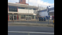
12 Nov 2022The route starts out fine at Gateshead Interchange and then goes through a public park before reaching a dual carriage way road. There is no safe way to cross suggested by the route though there is a footbridge a few metres further on. Once the crossing is made there is a pleasant walk through Gateshead Riverside Park before joining a cycle way towards the Teams area. The first of the routes pedestrian underpasses negotiated there is a section of walking beside a busy road before heading along marked footpaths towards the Trading Estate. A fair proportion of the walk is beside very busy roads so traffic noise id often present though this is a fairly urban walk so to be expected.
There is a possible option to cross the A1 Western Bypass over a footbridge which might be worth investigation as just after this to avoid crossing a busy road I detoured through another underpass. There then followed a short 'diversion' into the Trading Estate then another underpass. The aforementioned footbridge might prove an easier and more direct option.
I then joined a road section with no footpath. Though there wasn't much traffic it still left me feeling vulnerable. A right turn then took me through one of only two sections across stiles and fields. This took a route uphill joining a narrow road sadly with no footpath. I had to make several stops to allow cars to pass - albeit useful for me to catch my breath going uphill. This was a substantial road walking section. The final part was another 'cross country' section including a dodgy wooden footbridge across a stream, before reaching my destination.
As far as accessibility goes a lot of this walk could be done with wheels. The two cross country sections could maybe be avoided by continuing though Ladypark and Lamesley which would also have avoided one of the road sections and steep uphill climb! For this see review for Whikib one.
This is a good route spoilt by a couple of things which could be overcome with some tweaks.
-
Share your thoughts
Share your views about this route, give it a star rating, indicate whether it should be verified or not.
Include information that will be useful to others considering to walk or wheel it.
You can add up to 15 photos.
Other Routes for Kibblesworth—Gateshead See all Slow Ways
Review this better route and help establish a trusted network of walking routes.
Suggest a better route if it better meets our methodology.
Share your thoughts