Description
This is a Slow Ways route connecting Hereford and Ledbury.
Know of a better route? Share it here.
This is a Slow Ways route connecting Hereford and Ledbury.
Know of a better route? Share it here.
Status
This route has been reviewed by 2 people.
There are no issues flagged.
Photos for Herled one


Photos of this route will appear when they are added to a review. You can review this route here.
Information

Route status - Live
Reviews - 2
Average rating -
Is this route good enough? - Yes (2)
There are currently no problems reported with this route.
Downloads - 18
Surveys
We are working to build-up a picture of what routes look like. To do that we are asking volunteers to survey routes so that we can communicate features, obstacles and challenges that may make a route desirable or not.
Slow Ways surveyors are asked to complete some basic online training, but they are not vetted. If you are dependent on the survey information being correct in order to complete a route, we recommend that you think critically about the information provided. You may also wish to wait until more than one survey has been completed.
Help people know more about this route by volunteering to submit a survey.
- Complete the survey training.
- Submit a survey for this route.
Geography information system (GIS) data
Total length
Maximum elevation
Minimum elevation
Start and end points
Hereford
Grid Ref
SO5119339982
Lat / Lon
52.05607° / -2.71324°
Easting / Northing
351,193E / 239,982N
What3Words
froze.prop.skinny
Ledbury
Grid Ref
SO7109737711
Lat / Lon
52.03705° / -2.42276°
Easting / Northing
371,097E / 237,711N
What3Words
cries.wool.eyelash
Herled One's land is
| Hereford | |
|---|---|
| Grid Ref | SO5119339982 |
| Lat / Lon | 52.05607° / -2.71324° |
| Easting / Northing | 351,193E / 239,982N |
| What3Words | froze.prop.skinny |
| Ledbury | |
|---|---|
| Grid Ref | SO7109737711 |
| Lat / Lon | 52.03705° / -2.42276° |
| Easting / Northing | 371,097E / 237,711N |
| What3Words | cries.wool.eyelash |
| Arable | 57.4% |
| Other agricultural land | 4.7% |
| Pasture | 15.3% |
| Urban | 15.2% |
| Woods | 7.5% |
Data: Corine Land Cover (CLC) 2018
reviews
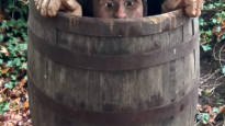
Nichowes
06 Nov 2022 (edited 09 Nov 2022)Nic Howes walked this route on November 5th, 2022.
The intensively farmed section from Ledbury westwards to the A4172 is not bad enough to knock any stars off what is a tremendous walk, crossing the renowned geological feature of the Woolhope Dome, the area of the UK that gives its name to the Woolhope Naturalists Field Club, founded in 1851 and thought to be the oldest such club in the world. https://www.woolhopeclub.org.uk As a fieldwork enthusiast for more than 60 years, I have to give this route 5 stars.
The route uploaded on 07 April 2021 was plotted with a "loose fit", presumably because it follows long distance trails that are clearly emphasised on the OS maps. The plotting has led to an underestimate of the distance of this walk, which is more than 17 miles - long for a Slow Way, even in Herefordshire. I plotted the route more precisely and accurately to create a more reliable .gpx file that may be downloaded as Herled two; I took the liberty of removing a southward loop of the Herefordshire Trail/Three Choirs Way southeast of Woolhope; this serves the dual purpose of keeping the route just under 17 miles and taking in the Butchers Arms pub, a hostelry with a reputation for good food and drink for well over forty years.
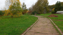
The route follows the Herefordshire Trail from Ledbury to Ridge Hill, although I could see no waymarks for the Trail leaving the starting point at Ledbury Market House. The route sets off down Bye Street, passing the prominent clock tower (Photo one, looking back towards the start). A short section of the former Ledbury to Gloucester railway line leads to Orchard Lane and then a series of alleys, suburban streets and an industrial estate lead to a crossing of the Ledbury bypass followed by a bridge over the River Leadon; at this point way markers for the Herefordshire Trail start to appear intermittently.
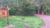
Waymarking through intensively farmed "Haygrove Ledbury" is patchy and Photo two may help to confirm that the correct route after the pond is to follow the concrete sleepers up towards the buildings and line of poplars. The route continues across farmland with some short sections of road walking; on my walk, one empty field had a sign alerting walkers to the presence of a bull and at least two others were cropped with no rolled or marked path. A short route section beside the fast, dangerous, noisy A4172 passes the entrance to Oasis Lodges (Photo three) https://www.oasislodges.co.uk
Soon after crossing the A4172 I encountered another heavily cropped field with no rolled or marked path but once at Aylton the geology, landscape and land use all begin to change to the great benefit of Slow Ways walkers, e.g. the impressive sight of the recently restored 13th century tithe barn at Court Farm (Photo four). Soon after come traditional orchards, Putley Mill and Putley church (Photos five, six and seven).
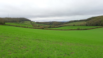
After Putley church the route passes the fine front of Putley Court (1712) and then contours across the bottom of the dip slope of the Woolhope Dome, rocks of Silurian age. What is the Woolhope Dome? Millions of years ago the layered sedimentary rocks of this area were pushed up at a single point to create an asymmetric dome with a teardrop-shaped plan form (think about pushing your toe up under a duvet). The principal point of uplift is under what is now Haugh Wood and the rocks dip away from this point in all directions. The rock layers have been eroded (worn down) since the uplift, mainly by the action of running water in the streams that drain the area. The result of this erosion is that today we see the “stumps” of the Dome in the form of two curving ridges of hard limestone that encircle a central dome of old, resistant rock; these harder rocks are separated from each other by curving vales of softer rock. The asymmetry of the dome means that the limestone ridges are more widely spaced on the eastern side of the Dome than on the western side.
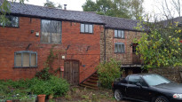
After passing through orchards the route meets a surfaced land and turns right along this to Hallend Farm (Photo eight). The steep, hipped roof midway along the buildings looks like that of a hop kiln, while the louvred roof crest of the end building might be ventilation for maltings; was this building once part of the brewing industry? Turning right at the junction, past the Farm, the pull of gravity begins to take effect on the walker as the road climbs steadily up the relatively gentle dip slope of the Aymestry Limestone.
Opposite a road junction, the route turns off the tarmac into an impressive holloway/green lane that passes through a historic landslip of 1575, aptly named The Wonder:
https://showmeengland.co.uk/ledbury/lifestyle/the-wonder-landslip-marcle-ridge-herefordshire/
The ancient green lane is a highlight of this route, one of many that to my mind makes it worthy of five stars. The route follows the green lane, contouring across the dip slope (note to geologists: following the strike) until turning right at a "T" junction with another track. At this point I willingly admit to uttering "Wow!" at the sudden discovery of yet another Herefordshire place that I'd missed in my 44 years living in the County: Photo nine shows the route ascending a track that crosses the bare rock of the dip slope of the Aymestry limestone, so the exposed layers of sedimentary rock appear like thick overlapping roof slates.
Once on the crest of the escarpment (Ridge Hill) at Hooper's Oak the Slow Ways walker has the option of following Herled one's southward loop of the Herefordshire Trail/Three Choirs Way or taking Herled two's shortcut via The Butchers Arms pub. Either option will descend the steep scarp slope of the Aymestry Limestone, cross the vale of Lower Ludlow Shale and climb (Herled two) or cut through (Herled one) the gentle dip slope of the Much Wenlock Limestone, going backwards in geological stratigraphy. Photo ten was taken looking south down the vale, scarp on left, vale in middle and dip on right.
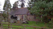
The village of Woolhope is centred around the church and The Crown pub and sits on higher ground on Woolhope Limestone, approached across a vale of Coalbrookdale Formation geology by both versions of the route. The route goes up the steps, through the lychgate, up towards the church force and then round to the left of the tower to access the cricket ground beyond. Across the lane from the cricket ground the route crosses a large field in which stands an impressive, solitary oak tree; it continues across a small stream in a narrow strip of woodland before joining the line of Peartree Walk, once an approach drive to nearby Wessington Court. At this point the route is crossing the oldest rocks, at the centre of the Dome: the Haugh Woods formation.
A lane is accessed via a cattle grid and then the route crosses Broadmoor Common to enter a short, narrow road section with no pavement on a blind bend - walkers should stay alert to approaching traffic. An opening appears on the right that leads to a variety of forestry tracks through Haugh Woods; walkers will need to use their preferred combination of map, compass or 'phone app to make sure that they follow the Three Choirs Way and not the well-used path that runs parallel to the surfaced lane, direct to Haugh Woods' large car park.
Haugh Woods provides a contrast to the fields and orchards crossed so far, and includes some broadleaved trees as well as conifers. Several other forestry tracks are crossed and after a relatively steep descent a "five ways" is reached at which point care is needed to find the steps down into another ancient holloway/green lane (Photo eleven). The dark mass at the top centre of the photograph is a yew tree; I have a photograph of the roots in the holloway bank but have not included it in this Review, so that Slow Way walkers have another "Wow!" opportunity.
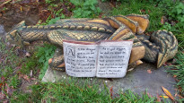
The route emerges from the holloway and passes several houses around The Pound to reach the Woolhope to Mordiford Road, which it follows for a short distance to Scutterdine; at this point it turns left down a track to a stream, with a diversion to Scutterdine Quarry, a Designated Local Geological Site with a fine exposure of the Woolhope Limestone. Skirting the edge of Hope Springs, the route continues to Bagpiper's Tump, where it dives off down a short holloway to a gate, beside which lurks an interpretation of a local legend (Photo twelve).
The route descends gently through an orchard, with Mordiford village in the view ahead. By a bridge over the mill leat crouches a representation of the subject of the legend - a dragon (Photo thirteen). The route continues beside the leat to Mordiford Mill which is in the process of painstaking restoration to working order (Photo fourteen). Care is needed crossing the busy B4224, beyond which the route passes another interpretation point on the Mordiford Dragon Trail:
https://dormingtonmordifordgroup-pc.gov.uk/the-parish/the-mordiford-dragon-project/
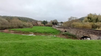
After crossing the Pentaloe Brook and back on the busy road after the quiet detour, the route turns left and crosses Mordiford Bridge on an extremely narrow pavement (Photo fifteen, looking back to Mordiford from the flood embankment). Just beyond the bridge, the route turns off the tarmac and follows the hedge back to the flood embankment of the River Lugg, built in the 1970s. The next section of the route along the crest of the flood embankment can feel more like the Essex salt marshes than landlocked Herefordshire; this is due to this area being a vast floodplain created by the confluence of the rivers Frome, Lugg and Wye.
The flood embankment leads to the northeast corner of Hampton Bishop village and then the route leaves the embankment and crosses fields to the entrance gate of The Court; the view back from these fields reveals the outline of Backbury Hill, providing a silhouette of the northern edge of the eroded Woolhope Dome (dip slope on left, scarp slope on right). The route now follows a lane round a bend, turns right to cross a field, crosses the B4224 again by a lay-by close to The Bunch of Carrots pub and mounts the flood embankment of the River Wye via steps. The route now continues along the Three Choirs Way via floodplain and riverbank, although the route has been slightly diverted from that shown on the OS map. On reaching Braemar Gardens in the eastern outer suburbs, the route follows the pavement alongside Hampton Park Road and once under the railway line a variety of quiet streets of Victorian houses lead to Hereford city centre.
Awv
17 May 2021This route is about 70% off road / 30% road and has a good variety of terrain. It's easy to navigate and there there were no obstacles or path blockages along the way. Some parts were muddy due to rain but nothing too difficult to deal with.
-
Share your thoughts
Share your views about this route, give it a star rating, indicate whether it should be verified or not.
Include information that will be useful to others considering to walk or wheel it.
You can add up to 15 photos.
Other Routes for Hereford—Ledbury See all Slow Ways
Review this better route and help establish a trusted network of walking routes.
Suggest a better route if it better meets our methodology.
Share your thoughts