Hay-on-Wye — Peterchurch
Haypet one

Slow Way not verified yet. Verify Haypet here.
Slow Way not verified yet. Verify Haypet here.
By a Slow Ways Volunteer on 07 Apr 2021
Description
This is a Slow Ways route connecting Hay-on-Wye and Peterchurch.
Know of a better route? Share it here.
This is a Slow Ways route connecting Hay-on-Wye and Peterchurch.
Know of a better route? Share it here.
Status
This route has been reviewed by 2 people.
There are no issues flagged.
Photos for Haypet one


Photos of this route will appear when they are added to a review. You can review this route here.
Information
Route status - Live
Reviews - 2
Average rating -
Is this route good enough? - Yes (2)
There are currently no problems reported with this route.
Downloads - 7
Surveys
We are working to build-up a picture of what routes look like. To do that we are asking volunteers to survey routes so that we can communicate features, obstacles and challenges that may make a route desirable or not.
Slow Ways surveyors are asked to complete some basic online training, but they are not vetted. If you are dependent on the survey information being correct in order to complete a route, we recommend that you think critically about the information provided. You may also wish to wait until more than one survey has been completed.
Help people know more about this route by volunteering to submit a survey.
- Complete the survey training.
- Submit a survey for this route.
Geography information system (GIS) data
Total length
Maximum elevation
Minimum elevation
Start and end points
Hay-on-Wye
Grid Ref
SO2291042236
Lat / Lon
52.07311° / -3.12617°
Easting / Northing
322,910E / 242,236N
What3Words
pencil.assures.linguists
Peterchurch
Grid Ref
SO3454838605
Lat / Lon
52.04197° / -2.95570°
Easting / Northing
334,548E / 238,605N
What3Words
guess.locker.juicy
Haypet One's land is
| Hay-on-Wye | |
|---|---|
| Grid Ref | SO2291042236 |
| Lat / Lon | 52.07311° / -3.12617° |
| Easting / Northing | 322,910E / 242,236N |
| What3Words | pencil.assures.linguists |
| Peterchurch | |
|---|---|
| Grid Ref | SO3454838605 |
| Lat / Lon | 52.04197° / -2.95570° |
| Easting / Northing | 334,548E / 238,605N |
| What3Words | guess.locker.juicy |
| Arable | 19.9% |
| Other agricultural land | 4.2% |
| Pasture | 56.7% |
| Urban | 4.4% |
| Woods | 14.8% |
Data: Corine Land Cover (CLC) 2018
reviews
Neil Summersgill
07 Oct 2023As Nick Howes said this is definitely a 5 star route. I had it in my head this was a long route for some reason so I had put it off for ages - think I got confused with Peterchurch to Talgarth - doh !
I started in Hay on Wye early (that car park gets busy !) and caught the bus to Peterchurch. The path goes past the church and across pasture and then up to a wood.
Its a bit of a slog up to Vagar Hill but keep checking behind as you go up as there are some great views back. This leads up to a telecom tower and then just past that you get a great view of pretty much the full length of The Black Mountains. Time for a brew and a mindfulness stop. There is a slightly tricky section along the track there as heavy vehicle has sunk some deep tyre tracks and they have filled up with mud and water. Luckily it wasn't too far.
This then opened up to a country lane which as you go round the bend suddenly hits you with an amazing wide view of the country beyond with Welsh Border hills on the far horizon. If that wasn't enough you get past a wood and suddenly the end of the Black Mountains is right on you and there are great views of Hay's Bluff and Lord Hereford's Knob / Twmpa.
Cusop Hill is fairly flat on top with no discernible path (and a load of sheep trails to tempt you off course) - pick the tree in the distance and just walk in a straight line there - there's a stile just behind it.
Head towards a little quarry on the tops with excellent views of the Black Mountains and Hay on Wye.
As you come down either my GPS or OS maps app was going astray at Capodolwyn I kept going off course. So head down to the left of the old tractor - through a wide gap in the middle of the gorse and there is a little stile with a white sign on it - head straight across the field opposite and down slightly left to a gate near some woodland (looks like some of it has been cut down recently). Its then straight ahead to Cusop. Keep an eye out for the mini goats to the left - very cute !
St Marys church at Cusop is a good place to take a mini detour - there is also a picnic table in the graveyard - its very picturesque there.
As you come into Cusop there is a T junction and the route cuts between some cottages first left and then immediately right - which takes you across a footbridge and a lovely stream view.
Then its plain sailing onto Hay on Wye - which is a fantastic little town - with plenty to see and spend your money on.
Absolutely great walk - so tranquil and beautiful and stunning in places.
Tempted to try an alternative route via Cusop Dingle and the old priory some time.
Note : West Lawn Common had some quite high bracken and it too me a little while to find the route - with so many false routes there as well.
Nichowes
03 Sep 2023 (edited 04 Sep 2023)Definitely a five star route, and a great gateway to the pleasures of walking in Herefordshire; I'll develop the reasoning for this statement with words and photos below. I encourage anyone who enjoys a good walk - with return bus transport occasionally - to try this route. Loads of food, drink and accommodation in Hay and the Nag's Head in Peterchurch is a hospitable hostelry. Route finding is easy by Herefordshire standards, with only occasional lapses in way marking on the ground. Even though I'm an experienced walker, I frequently consult the map to stay on track.
I appear to be the first person to review this route, which I find a bit surprising because of its high quality and the international fame of its starting point, Hay-on-Wye.
The route starts from Oxford Road car park - the largest in Hay - and ascends to the rear of recently restored Hay Castle (photo one). The route heads along the well-trodden Offa's Dyke Path (ODP) SE across fields and then leaves ODP to swing left across pretty, inhabited Cusop Dingle, formed by the Dulas Brook which is also the international border between Wales (Powys) and England (Herefordshire). The route follows the lane past Barking and Dagenham's Trewern outdoor centre before entering the peaceful churchyard at St Mary's, Cusop (photo two). I am reliably informed that Hay solicitor Armstrong's wife has an unmarked grave here; for the back story see "The Hay Poisoner".
After leaving the churchyard the route begins its biggest physical challenge for walkers: the steep 245 metre climb onto the summit of Cusop Hill. It's worth every step as the views open up, first of Hay, the Wye Valley and the Begwns (photo three) and later the whole east to west sweep of the north-facing scarp of the BBNP, the bilingual initialisation for my much-loved closest National Park (photo four).
A trot across the flat summit of Cusop Hill brings the route to the eastern of two high lanes connecting Hay to Michaelchurch Escley. I paused on the crossing of the Hill to photograph eyebright (photo five), an indicator of biodiverse grassland, as are wax cap fungi, some of which I also saw emerging. The route follows the quiet lane to the joint eastern tips of New House Wood and Cefn Hill Common, at which point it veers left through a gate onto the course of an old green lane (photo six) leading to the site of Castle Farm across which there is a dramatic view of the eastern flank of the Black Mountains (Mynydd Ddu), with the rightly renowned Black Hill and sharp "Cat's Back" closest (photo seven) - both in England.
Since New House the route has been following the Three Rivers Ride, which now turns right angle left from the green ride at the site of Castle Farm to head NE past the Vagar Hill communication tower and its redundant triangulation pillar (photo eight). The descent of the straight service road provides views across the Wye Valley and beyond into north Herefordshire (photo nine).
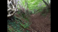
Turning right at the crossroads, the route follows the Three Rivers Ride along an eroded metalled road past Meadow Croft Farm to access the top of an ancient byway that leads down towards Snodhill, with its initial section crossing a mass of old tree roots (photo ten). The route continues to follow the Three Rivers Ride along the upper edge of West Lawn Common, where I saw a brilliant patch of autumn crocus aka naked boys or naked ladies - whatever takes your fancy (photo eleven). The backdrop to the view ahead is the Golden Valley, thought to have been enlarged by a glacier spilling over a diffluence col from the main Wye Glacier, and now occupied by the River Dore (D'or Norman or Dwr Welsh - or something else again?). Leave the common via a gate on the right into a secluded, ancient holloway (photo twelve).
Turning right along the lane in Snodhill the Three Rivers Ride is joined by the Herefordshire Trail, and it's worth trying to catch a glimpse of - or making a detour to inspect - the remains of Snodhill Castle to the NE. At a sharp right hand bend in the lane comes a "Wow" factor - a superb holloway leading up into Old Hill Wood (photo thirteen). Near the top of Old Hill Wood is an old oak that seems to be reaching out an arm in greeting (photo fourteen). The route descends from Old Hill and contours along the SW side of the Golden Valley, through sheep fields and meadows to Hinton Cross.
From Hinton Cross the route continues to Peterchurch village centre. Note that the village centre pub - the Boughton Arms - is closed at the time of this review, while the Nag's Head - also marked on the OS 1:25000 map - is accessed by a short walk from Hinton Cross; on this short walk I spotted wild hops growing in the hedgerow (photo fifteen).
Extra note on point to point walking: I did this walk on a Sunday, when I could not rely on bus transport so I made it a bike walk: bike on car rack to Peterchurch, bike off rack and secured in Peterchurch, drive on to Hay, park car, walk Haypet, cycle back to car, bike back on car rack. There are quiet lanes for cycling, away from the main Peterchurch, Dorstone, Hardwick, Hay road, but there are some long hills to climb. On a week day, it would be possible to build a timed plan to complete Haypet as a bus walk, starting and finishing at Hereford bus station.
-

Neil Summersgill
08 Oct 2023Great route Nick ! Have reviewed it - just one more review to go
-
Nichowes
08 Oct 2023Excellent! Thanks for your walk and review Neil and I'm really glad you enjoyed it.
-
Share your thoughts
Share your views about this route, give it a star rating, indicate whether it should be verified or not.
Include information that will be useful to others considering to walk or wheel it.
You can add up to 15 photos.
There are no other routes for Hay-on-Wye — Peterchurch
If you know a better way, then please let us know.
Review this better route and help establish a trusted network of walking routes.
Suggest a better route if it better meets our methodology.
Share your thoughts