Description
This is a Slow Ways route connecting Harpenden and Kimpton.
Know of a better route? Share it here.
This is a Slow Ways route connecting Harpenden and Kimpton.
Know of a better route? Share it here.
Status
This route has been reviewed by 3 people.
There are no issues flagged.
Photos for Harkim one


Photos of this route will appear when they are added to a review. You can review this route here.
Information
")
Route status - Live
Reviews - 3
Average rating -
Is this route good enough? - Yes (3)
There are currently no problems reported with this route.
Downloads - 5
Surveys
What is this route like?
Surveys are submitted by fellow users of this website and show what you might expect from this Slow Ways route. Scroll down the page to read more detailed surveys.
| Grade 4X based on 1 surveys | Sign up or log in to survey this route. | ||
|---|---|---|---|
| Description | Note | ||
| Grade 4: Route includes very rough surfaces including deep ruts, steep loose gravel, unmade paths and deep muddy sections. Wheelchairs may experience traction/wheel spin issues. Access grade X: At least one stile, flight of steps or other obstacle that is highly likely to block access for wheelchair and scooter users. |
Grading is based on average scores by surveyors. This slow way has 1 surveys. | ||
| Full grading description | |||
Only people who have completed our training can become Slow Ways surveyors and submit a survey. We do not vet contributors, so we cannot guarantee the quality or completeness of the surveys they complete. If you are dependent on the information being correct we recommend reading and comparing surveys before setting off.
Survey Photos
Facilities
Facilities in the middle third of this route.
Challenges
Potential challenges reported on this route. Some challenges are seasonal.
Obstacles
Obstacles on this route.
Accessibility
Is this route step and stile free?
Measurements
Surveyors were asked to measure the narrowest and steepest parts of paths.
The narrowest part of the path is 55.0cm (1)
The steepest uphill gradient walking East 20.0% (1)
The steepest uphill gradient walking West 21.0% (1)
The steepest camber gradient across the path 7.0% (1)
How clear is the waymarking on the route: Unclear in places (1)
Successfully completed
We asked route surveyors "Have you successfully completed this route with any of the following? If so, would you recommend it to someone with the same requirements?". Here is how they replied.
Recommended by an expert
We asked route surveyors "Are you a trained access professional, officer or expert? If so, is this route suitable for someone travelling with any of the following?" Here is how they replied.
Terrain
We asked route surveyors to estimate how much of the route goes through different kinds of terrain.
17.0% of the route is on roads (1)
20.0% of the route is lit at night (1)
17.0% of the route is paved (1)
70.0% of the route is muddy (1)
10.0% of the route is over rough ground (1)
15.0% of the route is through long grass (1)
Report a problem with this data
1 surveys
Information from verified surveys.
Geography information system (GIS) data
Total length
Maximum elevation
Minimum elevation
Start and end points
Harpenden
Grid Ref
TL1369614210
Lat / Lon
51.81497° / -0.35201°
Easting / Northing
513,696E / 214,210N
What3Words
fast.mutual.lifts
Kimpton
Grid Ref
TL1743818310
Lat / Lon
51.85105° / -0.29636°
Easting / Northing
517,438E / 218,310N
What3Words
dart.outer.prop
Harkim One's land is
| Harpenden | |
|---|---|
| Grid Ref | TL1369614210 |
| Lat / Lon | 51.81497° / -0.35201° |
| Easting / Northing | 513,696E / 214,210N |
| What3Words | fast.mutual.lifts |
| Kimpton | |
|---|---|
| Grid Ref | TL1743818310 |
| Lat / Lon | 51.85105° / -0.29636° |
| Easting / Northing | 517,438E / 218,310N |
| What3Words | dart.outer.prop |
| Arable | 48.4% |
| Pasture | 5.8% |
| Urban | 45.8% |
Data: Corine Land Cover (CLC) 2018
reviews
Strider
17 Jan 2023I walked from Harpenden to Kimpton.
A short road section takes you to Granary Lane, a pedestrian path which takes you out of the town then across fields down to the River Lea. There are steps up onto a disused railway which takes you alongside the Lea the across the Leasey Bridge. Short section by a road then up over big open fields paralleling big trees where the hedge line used to be. Along a very quiet road and across a common leads to the Kimpton Road which has a sporadic verge. I chose the road as the parallel path was very muddy, the road was not too busy and several dog walkers and I managed quite well. Up another muddy path that merged to a cinder track which took me down into Kimpton.
It had been very wet and a lot of the route had slippery mud. There are some steep parts but you are rewarded by views over the rolling Hertfordshire countryside. A walk that will be easier in summer.
Despite the hail and mud this was a beautiful walk through lovely countryside.
Steps and narrow muddy paths make it unsuitable for wheels.
Lwatson
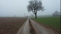
26 Dec 2021Walked this route both directions - first from Harpenden and then back after a lunch break in Kimpton. Much of the walk was fairly muddy and we were glad to be wearing our walking boots. On the way to Kimpton we followed the previous reviewer's advice to take the permissive footpath the other side of the hedge - this worked well as a way to avoid the road. On the way back we decided to avoid the mud and take the road which was not too busy. The route as a whole was very well waymarked and easy to follow, and I am sure there would have been some good views were it not for the foggy weather. Overall a lovely walk!.
-
Share your thoughts
BigDog
09 Nov 2021A pleasant walk along tracks and across fields, taking about 1hr 40 mins. Suitable for walkers of average fitness and mobility but sections are unsuitable for buggies, bikes etc. A few sections will be very muddy in wet weather and one roadside section along Kimpton Road between Blackmore Way and Beech Way has no real footpath - instead use the permissive way on the other side of the hedge opposite No 80. Note also that footpath has been rerouted around perimeter of Heron's Farm.
-
Share your thoughts
Share your views about this route, give it a star rating, indicate whether it should be verified or not.
Include information that will be useful to others considering to walk or wheel it.
You can add up to 15 photos.
There are no other routes for Harpenden — Kimpton
If you know a better way, then please let us know.
Review this better route and help establish a trusted network of walking routes.
Suggest a better route if it better meets our methodology.
Share your thoughts