Description
This is a Slow Ways route connecting Earlsfield and Tooting.
Know of a better route? Share it here.
This is a Slow Ways route connecting Earlsfield and Tooting.
Know of a better route? Share it here.
Status
This route has been reviewed by 8 people.
There are no issues flagged.
Photos for Eartoo one


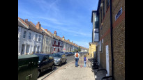


Photos of this route will appear when they are added to a review. You can review this route here.
Information
")
Route status - Live
Reviews - 8
Average rating -
Is this route good enough? - Yes (8)
There are currently no problems reported with this route.
Downloads - 5
Surveys
What is this route like?
Surveys are submitted by fellow users of this website and show what you might expect from this Slow Ways route. Scroll down the page to read more detailed surveys.
| Grade 1X based on 1 surveys | Sign up or log in to survey this route. | ||
|---|---|---|---|
| Description | Note | ||
| Grade 1: Entirely smooth and compacted surfaces. Access grade X: At least one stile, flight of steps or other obstacle that is highly likely to block access for wheelchair and scooter users. |
Grading is based on average scores by surveyors. This slow way has 1 surveys. | ||
| Full grading description | |||
Only people who have completed our training can become Slow Ways surveyors and submit a survey. We do not vet contributors, so we cannot guarantee the quality or completeness of the surveys they complete. If you are dependent on the information being correct we recommend reading and comparing surveys before setting off.
Survey Photos

Facilities
Facilities in the middle third of this route.
Challenges
Potential challenges reported on this route. Some challenges are seasonal.
Obstacles
Obstacles on this route.
Accessibility
Is this route step and stile free?
Measurements
Surveyors were asked to measure the narrowest and steepest parts of paths.
The narrowest part of the path is 80.0cm (1)
The steepest uphill gradient walking East 6.0% (1)
The steepest uphill gradient West: no data
The steepest camber: no data
How clear is the waymarking on the route: Clear (1)
Successfully completed
We asked route surveyors "Have you successfully completed this route with any of the following? If so, would you recommend it to someone with the same requirements?". Here is how they replied.
Recommended by an expert
We asked route surveyors "Are you a trained access professional, officer or expert? If so, is this route suitable for someone travelling with any of the following?" Here is how they replied.
Terrain
We asked route surveyors to estimate how much of the route goes through different kinds of terrain.
90.0% of the route is on roads (1)
100.0% of the route is lit at night (1)
100.0% of the route is paved (1)
There is no data on muddiness
There is no data on rough ground
There is no data on long grass
Report a problem with this data
1 surveys
Information from verified surveys.
Geography information system (GIS) data
Total length
Maximum elevation
Minimum elevation
Start and end points
Earlsfield
Grid Ref
TQ2605572984
Lat / Lon
51.44183° / -0.18764°
Easting / Northing
526,055E / 172,984N
What3Words
pirate.organs.held
Tooting
Grid Ref
TQ2746071453
Lat / Lon
51.42776° / -0.16798°
Easting / Northing
527,460E / 171,453N
What3Words
glow.skills.rides
Eartoo One's land is
| Earlsfield | |
|---|---|
| Grid Ref | TQ2605572984 |
| Lat / Lon | 51.44183° / -0.18764° |
| Easting / Northing | 526,055E / 172,984N |
| What3Words | pirate.organs.held |
| Tooting | |
|---|---|
| Grid Ref | TQ2746071453 |
| Lat / Lon | 51.42776° / -0.16798° |
| Easting / Northing | 527,460E / 171,453N |
| What3Words | glow.skills.rides |
| Urban | 100.0% |
Data: Corine Land Cover (CLC) 2018
reviews
Saira
03 Aug 2022A direct and enjoyable route between Tooting Broadway and Earlsfield! I passed my old secondary school on this one. There's lot of green spaces along the way, including Wandsworth Cemetery, which is beautiful. There are benches inside in case you want to have a break. As a local I think it's the best route to get to Earlsfield.
Ingrina
24 Jul 2022Good, direct route between Tooting Broadway and Earlsfield. The main road is a bit busy, but the pavement is wide and good. It also includes a bit of green space and interesting bits like Streatham Cemetery and the Earlsfield Public Library.
-
Share your thoughts
Mary Oz
24 Jul 2022A straightforward direct route, which was fairly pleasant despite some of it being along a main road, because it wasn’t too busy. There was a small section through a park, parched after a heatwave. There were also several interesting buildings, nice housing, and ghost signs to add interest.
-
Share your thoughts
Strider
24 Jul 2022I walked from Tooting to Earlsfield.
A hot day but a reasonable amount of shade. Some nice architecture , and the Streatham Cemetery is worth a visit if you have time.
Garratt Green was Garratt Brown after the scorching weather but a welcome open space. Again worth a wander if you're not in a hurry.
Good for wheels. Flat, no steps (but curbs), and paved all the way.
-
Share your thoughts
David Sanderson
24 Jul 2022Very straightforward and direct Slow Way which I started from Tooting on a sunny Saturday. The route follows pavement predominantly with a brief burst of greenery on Garratt Green. It was here that I witnessed a hurling team practicing. Only one road and that was the crossing shortly before Garratt Green that needed much mind at all. Well plotted, direct, safe and makes use of limited offroad options. A fine Slow Way.
-
Share your thoughts
Mtormey
23 Jul 2022I walked this route from Tooting to Earlsfield. There's three parts to the route - a stretch with a good distance along a larger busier road with good pavements, a stretch through the lovely Garratt Green, and a brief walk along a quieter residential street on the way to Earlsfield.
Overall, it's a very good route and one I'd happily recommend. It's safe, easy to navigate, accessible, direct, and as green as it could probably be. Definitely would walk again!.
-
Share your thoughts
SnowGoose
30 Apr 2021Direct route from station to station, brief amble across the green. Quickest and most flat route between Tooting Broadway and Earlsfield station.
Misses the lower part of Earlsfield 'centre', if you wanted more than just end to end, but is off the main roads as much as possible.
-
Share your thoughts
Tractiveeffort
27 Apr 2021Pavements are good, route is direct, some busy roads but not too bad.
-
Share your thoughts
Share your views about this route, give it a star rating, indicate whether it should be verified or not.
Include information that will be useful to others considering to walk or wheel it.
You can add up to 15 photos.
There are no other routes for Earlsfield — Tooting
If you know a better way, then please let us know.
Review this better route and help establish a trusted network of walking routes.
Suggest a better route if it better meets our methodology.
Share your thoughts