Chorleywood — Hemel Hempstead
Chohem two

Verified Slow Way
Verified by 100.00% of reviewers
Verified Slow Way
Verified by 100.00% of reviewers
By Derick Rethans on 05 Feb 2023
Description
Like chohem 1, but avoiding fields of horses, a detour along the Chess Valley (avoiding a hill), better approaches at both Chorleywood (avoiding narrow pavement road to station) and Hemel Hampstead (accurate information on how to cross busy roads)
Like chohem 1, but avoiding fields of horses, a detour along the Chess Valley (avoiding a hill), better approaches at both Chorleywood (avoiding narrow pavement road to station) and Hemel Hampstead (accurate information on how to cross busy roads)
Status
This route has been reviewed by 3 people.
There are no issues flagged.
Photos for Chohem two


Photos of this route will appear when they are added to a review. You can review this route here.
Information
Route status - Live
Reviews - 3
Average rating -
Is this route good enough? - Yes (3)
There are currently no problems reported with this route.
Downloads - 3
Surveys
What is this route like?
Surveys are submitted by fellow users of this website and show what you might expect from this Slow Ways route. Scroll down the page to read more detailed surveys.
| Grade 3X based on 1 surveys | Sign up or log in to survey this route. | ||
|---|---|---|---|
| Description | Note | ||
| Grade 3: Route includes rough surfaces that may include small boulders, potholes, shallow ruts, loose gravel, short muddy sections. Access grade X: At least one stile, flight of steps or other obstacle that is highly likely to block access for wheelchair and scooter users. |
Grading is based on average scores by surveyors. This slow way has 1 surveys. | ||
| Full grading description | |||
Only people who have completed our training can become Slow Ways surveyors and submit a survey. We do not vet contributors, so we cannot guarantee the quality or completeness of the surveys they complete. If you are dependent on the information being correct we recommend reading and comparing surveys before setting off.
Survey Photos
Facilities
Facilities in the middle third of this route.
Challenges
Potential challenges reported on this route. Some challenges are seasonal.
Obstacles
Obstacles on this route.
Accessibility
Is this route step and stile free?
Measurements
Surveyors were asked to measure the narrowest and steepest parts of paths.
The narrowest part of the path is 50.0cm (1)
The steepest uphill gradient walking East 16.0% (1)
The steepest uphill gradient walking West 18.0% (1)
The steepest camber gradient across the path 10.0% (1)
How clear is the waymarking on the route: Unclear in places (1)
Successfully completed
We asked route surveyors "Have you successfully completed this route with any of the following? If so, would you recommend it to someone with the same requirements?". Here is how they replied.
Recommended by an expert
We asked route surveyors "Are you a trained access professional, officer or expert? If so, is this route suitable for someone travelling with any of the following?" Here is how they replied.
Terrain
We asked route surveyors to estimate how much of the route goes through different kinds of terrain.
35.0% of the route is on roads (1)
30.0% of the route is lit at night (1)
20.0% of the route is paved (1)
10.0% of the route is muddy (1)
15.0% of the route is over rough ground (1)
15.0% of the route is through long grass (1)
Report a problem with this data
1 surveys
Information from verified surveys.
Geography information system (GIS) data
Total length
Maximum elevation
Minimum elevation
Start and end points
Chorleywood
Grid Ref
TQ0260396111
Lat / Lon
51.65444° / -0.51821°
Easting / Northing
502,603E / 196,111N
What3Words
lied.rounds.relate
Hemel Hempstead
Grid Ref
TL0430605947
Lat / Lon
51.74253° / -0.49066°
Easting / Northing
504,306E / 205,947N
What3Words
grew.pool.major
| Chorleywood | |
|---|---|
| Grid Ref | TQ0260396111 |
| Lat / Lon | 51.65444° / -0.51821° |
| Easting / Northing | 502,603E / 196,111N |
| What3Words | lied.rounds.relate |
| Hemel Hempstead | |
|---|---|
| Grid Ref | TL0430605947 |
| Lat / Lon | 51.74253° / -0.49066° |
| Easting / Northing | 504,306E / 205,947N |
| What3Words | grew.pool.major |
Sorry Land Cover data is not currently available for this route. Please check back later.
reviews
Lwatson
15 Apr 2023I walked from Hemel to Chorleywood. The section coming out of Hemel station down London Road is probably the least pleasant part of the walk. London Road itself was very busy but with a slight detour to a visible set of traffic lights this was not too bad.
There is a lot less road walking than would initially appear from the route map. Felden Road has a wide grassy verge for quite some way, and other verges and a well-signposted permissive path keep you off the tarmac much of the time. Most of the tarmac is down two very small lanes with few cars.
One field north of Chipperfield was very waterlogged when I walked it, and there were some other pretty muddy sections, but for the most part it was fine underfoot.
The route was very easy to navigate and benefitted from some lovely scenery pretty much throughout. Bonus points for avoiding fields of horses which are fairly ubiquitous around Chipperfield and Sarratt!.
Strider
10 Apr 2023I walked from Chorleywood to Hemel Hempstead.
A good walk, Chorleywood common is a short hop from the station and then joining the Chess Valley walk following The Chess for a way through woods, commons and well made paths past Sarratt. Then there is Moor Lane, the first of several road sections. This lane is narrow with no verges, but very quiet, there was one car but it was crawling along at 15mph. All the road sections on this route are good, either very quiet and/or with good verges/paths beside them, with the exception of a 30m part as you enter/leave the South exit of Roughdown Common where care needs to be taken. Between the road sections there are many beautiful woods, riverside paths, quaint villages, common land and huge farm fields, lots of variety. The terrain is undulating and there are some nice views across the countryside.
Steps at either end, stiles and gates make this unsuitable for wheels.
-
Share your thoughts
Derick Rethans
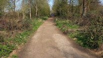
05 Feb 2023I walked this from Hemel Hempstead to Chorleywood on a cloudy Saturday morning. There was not a lot of rain in the last week, and all the paths were easy going.
From Hemel Hempstead, I had some trouble getting to the south side of the station. Apparently you can only get out on that side if you have a special swipe card. So instead, I had to walk around and cross the very busy London Road to get to the start of the "real" walk. (photo #1)
There was a fairly long climb up through Felden along a road with no pavement, but also luckily with little traffic (photo #2). Much of the walk was be on a path, track, or road with hedges along each side. But it was never unsafe as there was very little traffic, and the traffic that did show up wasn't moving very fast.
After crossing Rucklers Lane, there was a long trek up and down a hill through grassy farmland (photo #4). At the bottom a lovely track brought me to "Tower Hill", where footpaths through fields were easy to walk. I did not like the signs "bull in field" though. Luckily, these signs were a lie. After a lovely walk through some woods, with some good views of a village in the valley below, I ended up crossing a road.
My pre-planned route (Chohem 1) had me go along the road, but luckily there is now a permissive footpath that avoids the road, where there was fast traffic. At the end of the field, there was now a pavement to make the walk safe, and a path through the woods allowed me to avoid another road walking section.
After walking past Rosehall Wood, Chohem 1 suggested I go through some fields to Dawes Common before going over another hill to get to the river
Chess. However there were a fair amount of horses in the field, and as I don't really trust these animals I decided to walk around them (photo #7). This is why there is now this Chohem 2! Unfortunately that meant a little road walking, but luckily again, there was little traffic.
This route also avoids a hill, and another few fields of horses. It also meant that I walked along the lovely river Chess for a fair distance, as part of the
Chess Valley Walk.
I spotted the first snow drops of the year along the lanes and the Chess Valley Walk themselves, and in the river a Little Egret (photo #9). Once I had crossed the river on a wooden bridge, the rest of this first section went through the Chorleywood House Estate, and Chorleywood Common (photo #11) to end up close to the tube station.
A lovely walk, even though there is some road walking involved.
-
Share your thoughts
Share your views about this route, give it a star rating, indicate whether it should be verified or not.
Include information that will be useful to others considering to walk or wheel it.
You can add up to 15 photos.
Other Routes for Chorleywood—Hemel Hempstead See all Slow Ways
Review this better route and help establish a trusted network of walking routes.
Suggest a better route if it better meets our methodology.
Share your thoughts