Chippenham — Royal Wootton Bassett
Chiroy one

Slow Way not verified yet. Verify Chiroy here.
Slow Way not verified yet. Verify Chiroy here.
By a Slow Ways Volunteer on 07 Apr 2021
Description
This is a Slow Ways route connecting Chippenham and Royal Wootton Bassett.
Know of a better route? Share it here.
This is a Slow Ways route connecting Chippenham and Royal Wootton Bassett.
Know of a better route? Share it here.
Status
This route has been reviewed by 1 person.
This route has been flagged (1 times) for reasons relating to access.
Photos for Chiroy one

Photos of this route will appear when they are added to a review. You can review this route here.
Information
Route status - Live
Reviews - 1
Average rating -
Is this route good enough? - No (1)
Problems reported - Access (1)
Downloads - 11
Surveys
We are working to build-up a picture of what routes look like. To do that we are asking volunteers to survey routes so that we can communicate features, obstacles and challenges that may make a route desirable or not.
Slow Ways surveyors are asked to complete some basic online training, but they are not vetted. If you are dependent on the survey information being correct in order to complete a route, we recommend that you think critically about the information provided. You may also wish to wait until more than one survey has been completed.
Help people know more about this route by volunteering to submit a survey.
- Complete the survey training.
- Submit a survey for this route.
Geography information system (GIS) data
Total length
Maximum elevation
Minimum elevation
Start and end points
Chippenham
Grid Ref
ST9202773318
Lat / Lon
51.45878° / -2.11614°
Easting / Northing
392,027E / 173,318N
What3Words
legs.daydreams.estuaries
Royal Wootton Bassett
Grid Ref
SU0673382577
Lat / Lon
51.54205° / -1.90430°
Easting / Northing
406,733E / 182,577N
What3Words
financial.piano.popular
Chiroy One's land is
| Chippenham | |
|---|---|
| Grid Ref | ST9202773318 |
| Lat / Lon | 51.45878° / -2.11614° |
| Easting / Northing | 392,027E / 173,318N |
| What3Words | legs.daydreams.estuaries |
| Royal Wootton Bassett | |
|---|---|
| Grid Ref | SU0673382577 |
| Lat / Lon | 51.54205° / -1.90430° |
| Easting / Northing | 406,733E / 182,577N |
| What3Words | financial.piano.popular |
| Arable | 30.7% |
| Pasture | 41.0% |
| Urban | 24.5% |
| Woods | 3.8% |
Data: Corine Land Cover (CLC) 2018
review
Brian
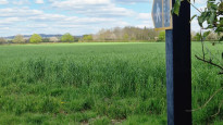
26 Apr 2023This is a curate's egg of a walk, traveling from RWB to Chippenham, it is a mix of normal UK footpaths, well groomed estates and golf course, attractive sections and views, together with quiet lanes and tracks, and an interesting section around Lyneham airfield with its military hardware on display.
The downsides are the number of diversions having to be taken to avoid lively cows, and footpaths which have been deliberately extinguished by landowners.
These include
a ) ST 97001 77157 : walking through someones garden, the stile into field, all means of access has been removed, preventing walking across fields to ST 95901 76688
b ) ST 99337 77999 to ST 99270 77913 : path has been removed
c ) ST 99191 77763 to ST 98644 77404 : excitable cows
( a ) and ( c ) involved diverting route onto quiet lanes, whilst ( b ) involved much to-in and fro-in trying to find the path in a wilderness, then opting on an alternative route entirely
As a result, I thought it appropriate to upload another route, which takes out these issues.
This alternative shows where the actual route on the ground is, rather than the OS map line.
All issues above have been formally notified to Wilts ROW Department - together with crops over paths, damaged stiles etc [ which I regarded as surmountable ]
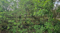
All photos indicate the non existing paths.
Share your views about this route, give it a star rating, indicate whether it should be verified or not.
Include information that will be useful to others considering to walk or wheel it.
You can add up to 15 photos.
Other Routes for Chippenham—Royal Wootton Bassett See all Slow Ways
Review this better route and help establish a trusted network of walking routes.
Suggest a better route if it better meets our methodology.
Share your thoughts