Description
This route was trialled on the ground on Tuesday 18th April, 2023 by Nic Howes as an alternative to the original route (now Broled One) because that route was plotted along several private paths and drives. Broled Two follows PROWs and public roads
This route was trialled on the ground on Tuesday 18th April, 2023 by Nic Howes as an alternative to the original route (now Broled One) because that route was plotted along several private paths and drives. Broled Two follows PROWs and public roads
Status
This route has been reviewed by 1 person.
There are no issues flagged.
Photos for Broled two


Photos of this route will appear when they are added to a review. You can review this route here.
Information

Route status - Live
Reviews - 1
Average rating -
Is this route good enough? - Yes (1)
There are currently no problems reported with this route.
Downloads - 3
Surveys
We are working to build-up a picture of what routes look like. To do that we are asking volunteers to survey routes so that we can communicate features, obstacles and challenges that may make a route desirable or not.
Slow Ways surveyors are asked to complete some basic online training, but they are not vetted. If you are dependent on the survey information being correct in order to complete a route, we recommend that you think critically about the information provided. You may also wish to wait until more than one survey has been completed.
Help people know more about this route by volunteering to submit a survey.
- Complete the survey training.
- Submit a survey for this route.
Geography information system (GIS) data
Total length
Maximum elevation
Minimum elevation
Start and end points
Bromyard
Grid Ref
SO6543354774
Lat / Lon
52.19013° / -2.50707°
Easting / Northing
365,433E / 254,774N
What3Words
targeted.operating.clutter
Ledbury
Grid Ref
SO7109737711
Lat / Lon
52.03705° / -2.42276°
Easting / Northing
371,097E / 237,711N
What3Words
cries.wool.eyelash
| Bromyard | |
|---|---|
| Grid Ref | SO6543354774 |
| Lat / Lon | 52.19013° / -2.50707° |
| Easting / Northing | 365,433E / 254,774N |
| What3Words | targeted.operating.clutter |
| Ledbury | |
|---|---|
| Grid Ref | SO7109737711 |
| Lat / Lon | 52.03705° / -2.42276° |
| Easting / Northing | 371,097E / 237,711N |
| What3Words | cries.wool.eyelash |
Sorry Land Cover data is not currently available for this route. Please check back later.
review
Nichowes
18 Apr 2023 (edited 21 Apr 2023)Nic Howes walked this route on Tuesday 18th April, 2023. The route follows the Frome valley at first and then crosses the watershed of Fromes Hill to enter the Leadon valley. Most of the route is on footpaths and bridleways and the few sections that do follow roads are quiet, although it is important to stay alert to fast approaching traffic. Waymarking is patchy, as is the norm, even on the Herefordshire Trail. Conditions underfoot are also variable: although some land is managed in a walker-unfriendly manner, this is the minority and thus the route is worthy of four stars. There is a great deal to see, with some fine vernacular architecture, much of it related to the area's long history of growing hops and orchard fruit.
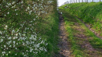
The starting point is Bromyard Heritage Centre (photo one) and the route leaves Bromyard via a foot tunnel under the A44 and a short hill up to the hospital. A quiet surfaced lane leads to Little Froome Farm, beyond which an old greenway continues past blackthorn (photo two) towards a disused corn mill, the two chimney stacks of which may be seen on the left of the route.
On the left of the next section of the route, the infant River Frome wiggles around along the bottom of the much larger loops of its valley, suggesting that it might be a "misfit" stream. The large loops are thought to have been created by torrents of meltwater at the end of the last Ice Age; once the Frome's discharge reduced, the stream adjusted its channel to the lower discharge by forming smaller, tighter meanders along its course.
Beyond Avenbury, the route passes the house, hop barn and drying tower of Brook House Farm (photo three). Brook House Farm has specialised in hops and cider apples and has diversified to include "glamping" and other activities, such as recommended walk routes to local pubs (photo four): https://brookhouse.fm
There is a large hop field on the eastern side of the route (photo five - the yellow is dandelions) after passing Brookhouse Wood. There is more fine vernacular architecture at Upper Venn Farm (photo six). Further along, at Paunton Court the route passes Frome Valley Vineyard (photo seven): https://www.fromevalleyvineyard.co.uk
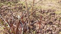
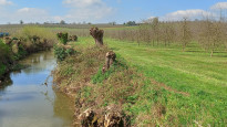
Continuing southwards, the route follows rows of hopbines, providing a good view of the anchored strings by each bine (photo eight). Next up, the route negotiates rows of orchard trees to then cross the River Frome with its pollarded willows (photo nine) to access the quiet lane through to Bishops Frome. The plotted route avoids the village centre by following a narrow footpath to cross a recreation ground and on to the church; walkers requiring refreshment in Bishops Frome may want to take a short diversion to the Green Dragon pub there.
From Bishops Frome church the route recrosses the River Frome and the wide floor associated with that stream's larger meltwater discharge during the Ice Age. The route begins the ascent of the watershed of Fromes Hill, meeting a lane and following it uphill past the Majors Arms pub, with its wonderful views (photo ten, NB limited opening hours). The lane climbs to the summit of Fromes Hill and meets the A4103 Hereford to Worcester road with its associated services, eye-catching T34 tank and Wheatsheaf pub (photo eleven).
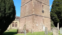
From Fromes Hill the route continues south across fields and orchards to Catley Cross Farm with its collection of vintage farm equipment, including the baler in the centre of photo twelve. After Catley Cross Farm come more fields and orchards that lead through to the attractive village of Bosbury, where the church tower is separate from the rest of the building (photo thirteen). Intensive farming between Bosbury and Raven Hill Wood may present some challenges to walkers, necessitating particularly close reference to the map to stay on track.
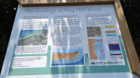
Skirting Raven Hill Wood the route soon reaches Wellington Heath (where there is another pub) followed by a pull up to the edge of Frith Wood. Walkers' approach to Ledbury from Frith Wood is one of the best routes in and out of that town, following the Herefordshire Trail and Geopark Way. There are fine views of Stephen Ballard's viaduct (1859-60) over the River Leadon, followed by an unusual perspective of Ledbury station, from above the western tunnel portal. Just before descending into the town centre, the route passes an interpretation panel for the geology of Dog Hill Wood (photo fourteen).
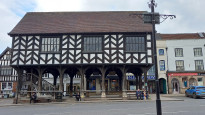
The route finishes at Ledbury market house (photo fifteen).
Share your views about this route, give it a star rating, indicate whether it should be verified or not.
Include information that will be useful to others considering to walk or wheel it.
You can add up to 15 photos.
Other Routes for Bromyard—Ledbury See all Slow Ways
Review this better route and help establish a trusted network of walking routes.
Suggest a better route if it better meets our methodology.
Share your thoughts