Description
This route is very similar to Brikey One, but makes the improvements that the (two) reviewers have suggested.
I've not walked this route. I decided to go via the river instead, which is only a little bit further but a lot more green, blue, quiet and easy to navigate. That will be Brikey Three. Someone will likely be able to suggest another route that is far more direct, but with much more nearby traffic
Status
This route has been reviewed by 5 people.
This route has been flagged (1 times) for reasons relating to safety.
Photos for Brikey two


Photos of this route will appear when they are added to a review. You can review this route here.
Information
")
Route status - Live
Reviews - 5
Average rating -
Is this route good enough? - Yes (4) No (1)
Problems reported - Safety (1)
Downloads - 5
Surveys
What is this route like?
Surveys are submitted by fellow users of this website and show what you might expect from this Slow Ways route. Scroll down the page to read more detailed surveys.
| Grade 4X based on 1 surveys | Sign up or log in to survey this route. | ||
|---|---|---|---|
| Description | Note | ||
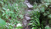
| Grade 4: Route includes very rough surfaces including deep ruts, steep loose gravel, unmade paths and deep muddy sections. Wheelchairs may experience traction/wheel spin issues. Access grade X: At least one stile, flight of steps or other obstacle that is highly likely to block access for wheelchair and scooter users. |
Grading is based on average scores by surveyors. This slow way has 1 surveys. | ||
| Full grading description | |||
Only people who have completed our training can become Slow Ways surveyors and submit a survey. We do not vet contributors, so we cannot guarantee the quality or completeness of the surveys they complete. If you are dependent on the information being correct we recommend reading and comparing surveys before setting off.
Survey Photos
Facilities
Facilities in the middle third of this route.
Challenges
Potential challenges reported on this route. Some challenges are seasonal.
Obstacles
Obstacles on this route.
Accessibility
Is this route step and stile free?
Measurements
Surveyors were asked to measure the narrowest and steepest parts of paths.
The narrowest part of the path is 50.0cm (1)
The steepest uphill gradient walking East 27.0% (1)
The steepest uphill gradient walking West 31.0% (1)
The steepest camber: no data
How clear is the waymarking on the route: Unclear in places (1)
Successfully completed
We asked route surveyors "Have you successfully completed this route with any of the following? If so, would you recommend it to someone with the same requirements?". Here is how they replied.
Recommended by an expert
We asked route surveyors "Are you a trained access professional, officer or expert? If so, is this route suitable for someone travelling with any of the following?" Here is how they replied.
Terrain
We asked route surveyors to estimate how much of the route goes through different kinds of terrain.
There is no data on how much of this route is on roads
There is no data on how much of this route is lit at night
Thereis no data on amount of route paved
There is no data on muddiness
There is no data on rough ground
There is no data on long grass
Report a problem with this data
1 surveys
Information from verified surveys.
Geography information system (GIS) data
Total length
Maximum elevation
Minimum elevation
Start and end points
Bristol
Grid Ref
ST5894073546
Lat / Lon
51.45939° / -2.59239°
Easting / Northing
358,940E / 173,546N
What3Words
dollar.perky.study
Keynsham
Grid Ref
ST6547768493
Lat / Lon
51.41439° / -2.49780°
Easting / Northing
365,477E / 168,493N
What3Words
preoccupied.grape.launch
| Bristol | |
|---|---|
| Grid Ref | ST5894073546 |
| Lat / Lon | 51.45939° / -2.59239° |
| Easting / Northing | 358,940E / 173,546N |
| What3Words | dollar.perky.study |
| Keynsham | |
|---|---|
| Grid Ref | ST6547768493 |
| Lat / Lon | 51.41439° / -2.49780° |
| Easting / Northing | 365,477E / 168,493N |
| What3Words | preoccupied.grape.launch |
Sorry Land Cover data is not currently available for this route. Please check back later.
reviews
Mary Oz
11 Oct 2023I walked from Keynsham to Bristol on a drizzly day. I’m afraid I’m going to fail this route because I think the dual carriageway crossing of the A4174 is likely to be dangerous at most times. I note that the four other reviews were all done by a group who all walked together on a nice summer’s day, possibly a Sunday when this road might have been a bit quieter. Others have mentioned this dangerous crossing in their reviews of BriKey One and Three. The cars were so fast and frequent, I felt that when I actually found a gap between them, if I’d have tripped as I crossed, I would have been dead a second later.
For me on a wet autumn day, I also found some of the footpaths to be rather overgrown, (even invisible), sometimes with nettles or Himalayan Balsam, and my legs got soaked. I could imagine these paths are nice on a dry early summer day. Also the actual route on the ground differed from the OS path in a few places, but not enough to cause too much of a problem following it.
The industrial estate, with the usual pavement parking and smell and noise, was rewarded by a microbrewery and taproom at the end!
Coming into Bristol down Sandy Park Road was pleasant with lots of shops and cafés. There were loads of walls full of wonderful graffiti and street art from here onwards. There were also a lot of fast cyclists along the riverside path. It was interesting to see the huge tidal drop, and some riverside historic remains.
The final route to Bristol Bus Station from Temple Meads train station passed some interesting places too.
Potentially a great route, but not with that awful road crossing.
Edyth Thomas
04 Jul 2023A beautiful flat easy walk, lovely scenery with 2 nice pubs to stop and have a relaxing drink while overlooking the river. I would definitely walk it again and recommend it to others.
-
Share your thoughts
Samantha Johnson
04 Jul 2023Lovely walk with beautiful scenery, very relaxing being by the canal with plenty of wildlife along the way also 2 lovely pubs to sit, relax and enjoy the countryside.
-
Share your thoughts
Serena Tyler
04 Jul 2023Fantastic walk, relaxing beautiful and varied scenery from water, cottages, greenery.
-
Share your thoughts
Sophie Brown
04 Jul 2023Absolutely a beautiful easy flat route.
With a mixture of countryside, river views, Path runs alongside part of the Kennet And Avon Canal farm animals, two pubs for resting
Main road leading back to the bus stop to Bristol
The public paths through the countryside are very well kept.
-
Share your thoughts
Share your views about this route, give it a star rating, indicate whether it should be verified or not.
Include information that will be useful to others considering to walk or wheel it.
You can add up to 15 photos.
Other Routes for Bristol—Keynsham See all Slow Ways
Review this better route and help establish a trusted network of walking routes.
Suggest a better route if it better meets our methodology.
Share your thoughts