Description
This is a Slow Ways route connecting Alsager and Congleton.
Know of a better route? Share it here.
This is a Slow Ways route connecting Alsager and Congleton.
Know of a better route? Share it here.
Status
This route has been reviewed by 1 person.
There are no issues flagged.
Photos for Alscon one


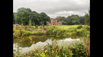
Photos of this route will appear when they are added to a review. You can review this route here.
Information

Route status - Live
Reviews - 1
Average rating -
Is this route good enough? - Yes (1)
There are currently no problems reported with this route.
Downloads - 9
Surveys
We are working to build-up a picture of what routes look like. To do that we are asking volunteers to survey routes so that we can communicate features, obstacles and challenges that may make a route desirable or not.
Slow Ways surveyors are asked to complete some basic online training, but they are not vetted. If you are dependent on the survey information being correct in order to complete a route, we recommend that you think critically about the information provided. You may also wish to wait until more than one survey has been completed.
Help people know more about this route by volunteering to submit a survey.
- Complete the survey training.
- Submit a survey for this route.
Geography information system (GIS) data
Total length
Maximum elevation
Minimum elevation
Start and end points
Alsager
Grid Ref
SJ8006355150
Lat / Lon
53.09320° / -2.29916°
Easting / Northing
380,063E / 355,150N
What3Words
disarmed.bunks.neutron
Congleton
Grid Ref
SJ8594262962
Lat / Lon
53.16361° / -2.21172°
Easting / Northing
385,942E / 362,962N
What3Words
order.media.fetch
Alscon One's land is
| Alsager | |
|---|---|
| Grid Ref | SJ8006355150 |
| Lat / Lon | 53.09320° / -2.29916° |
| Easting / Northing | 380,063E / 355,150N |
| What3Words | disarmed.bunks.neutron |
| Congleton | |
|---|---|
| Grid Ref | SJ8594262962 |
| Lat / Lon | 53.16361° / -2.21172° |
| Easting / Northing | 385,942E / 362,962N |
| What3Words | order.media.fetch |
| Arable | 11.0% |
| Pasture | 41.9% |
| Urban | 47.1% |
Data: Corine Land Cover (CLC) 2018
review
Nathan Smith
13 Sep 2022This was a really pleasurable route to follow, ~14km made it a really nice distance to walk, it's mainly flat as it follows the canal the majority of the way on the towpaths. The route set out in Slow Ways is completely accurate and able to be followed without any issues, I'd definitely walk it again and would recommend to others.
That being said the start and finish points do involve slightly more hilly terrain, Canal Street heading out of Congleton is the way up to the canal and is a kilometer of a steep hill but slowing your pace makes it more than manageable and once you get into Alsager the footpath you join to head in the direction of the train station it quite up and down.
It's worth mentioning that depending on where you're headed in Alsager you don't need to use this footpath, if you're wanting to get to the town centre then one you leave the canal and join on to the pavement on the main road, keep walking straight along this road and you'll get to the town centre.
The varied scenery and wildlife I came across on this walk also made it a very interesting walk to do even with the fact that you're on the same path for a good portion of the walk with great views of the folly on Mow Cop as well as just general countryside views.
May not be suitable for wheelchairs as at times the towpaths are just wide enough to walk on and the towpaths can get a little uneven which may make for an uncomfortable journey.
Share your views about this route, give it a star rating, indicate whether it should be verified or not.
Include information that will be useful to others considering to walk or wheel it.
You can add up to 15 photos.
There are no other routes for Alsager — Congleton
If you know a better way, then please let us know.
Review this better route and help establish a trusted network of walking routes.
Suggest a better route if it better meets our methodology.
Share your thoughts