Description
This is a Slow Ways route connecting Abingdon and Oxford.
Know of a better route? Share it here.
This is a Slow Ways route connecting Abingdon and Oxford.
Know of a better route? Share it here.
Status
This route has been reviewed by 4 people.
There are no issues flagged.
Photos for Abioxf one


Photos of this route will appear when they are added to a review. You can review this route here.
Information
")
Route status - Live
Reviews - 4
Average rating -
Is this route good enough? - Yes (4)
There are currently no problems reported with this route.
Downloads - 18
Surveys
What is this route like?
Surveys are submitted by fellow users of this website and show what you might expect from this Slow Ways route. Scroll down the page to read more detailed surveys.
| Grade 4X based on 1 surveys | Sign up or log in to survey this route. | ||
|---|---|---|---|
| Description | Note | ||
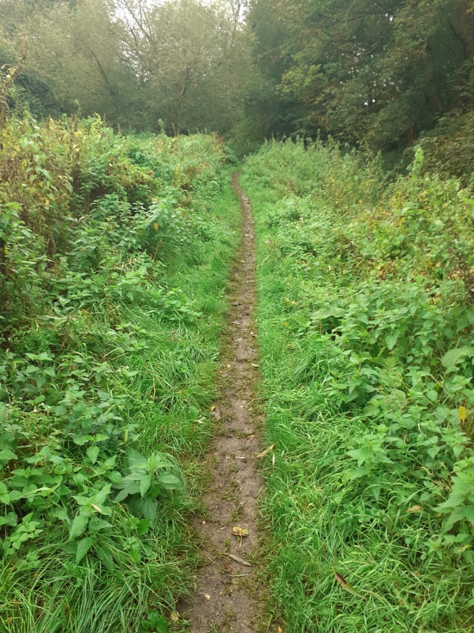
| Grade 4: Route includes very rough surfaces including deep ruts, steep loose gravel, unmade paths and deep muddy sections. Wheelchairs may experience traction/wheel spin issues. Access grade X: At least one stile, flight of steps or other obstacle that is highly likely to block access for wheelchair and scooter users. |
Grading is based on average scores by surveyors. This slow way has 1 surveys. | ||
| Full grading description | |||
Only people who have completed our training can become Slow Ways surveyors and submit a survey. We do not vet contributors, so we cannot guarantee the quality or completeness of the surveys they complete. If you are dependent on the information being correct we recommend reading and comparing surveys before setting off.
Survey Photos
Facilities
Facilities in the middle third of this route.
Challenges
Potential challenges reported on this route. Some challenges are seasonal.
Obstacles
Obstacles on this route.
Accessibility
Is this route step and stile free?
Measurements
Surveyors were asked to measure the narrowest and steepest parts of paths.
Narrowest part of path: no data
The steepest uphill gradient walking East 10.0% (1)
The steepest uphill gradient walking West 10.0% (1)
The steepest camber: no data
How clear is the waymarking on the route: Clear (1)
Successfully completed
We asked route surveyors "Have you successfully completed this route with any of the following? If so, would you recommend it to someone with the same requirements?". Here is how they replied.
Recommended by an expert
We asked route surveyors "Are you a trained access professional, officer or expert? If so, is this route suitable for someone travelling with any of the following?" Here is how they replied.
Terrain
We asked route surveyors to estimate how much of the route goes through different kinds of terrain.
10.0% of the route is on roads (1)
10.0% of the route is lit at night (1)
25.0% of the route is paved (1)
75.0% of the route is muddy (1)
20.0% of the route is over rough ground (1)
There is no data on long grass
Report a problem with this data
1 surveys
Information from verified surveys.
Geography information system (GIS) data
Total length
Maximum elevation
Minimum elevation
Start and end points
Abingdon
Grid Ref
SU4979097050
Lat / Lon
51.67003° / -1.28141°
Easting / Northing
449,790E / 197,050N
What3Words
coins.rent.fines
Oxford
Grid Ref
SP5050306292
Lat / Lon
51.75306° / -1.26977°
Easting / Northing
450,503E / 206,292N
What3Words
hidden.prep.round
Abioxf One's land is
| Abingdon | |
|---|---|
| Grid Ref | SU4979097050 |
| Lat / Lon | 51.67003° / -1.28141° |
| Easting / Northing | 449,790E / 197,050N |
| What3Words | coins.rent.fines |
| Oxford | |
|---|---|
| Grid Ref | SP5050306292 |
| Lat / Lon | 51.75306° / -1.26977° |
| Easting / Northing | 450,503E / 206,292N |
| What3Words | hidden.prep.round |
| Arable | 38.0% |
| Moors | 2.2% |
| Pasture | 34.7% |
| Urban | 17.0% |
| Woods | 8.1% |
Data: Corine Land Cover (CLC) 2018
reviews
Sam McKavanagh
24 Sep 2022This is a beautiful and often quiet (until you reach Iffley in Oxford. From Sanford it becomes more accessible as a route. The stretch down to Abingdon from Sandford Lock is deeply rutted river path.
The parts opposite Nuneham house are really beautiful and there's a great chance to see lots of amazing birds as you get around the Radley lakes area.
Martin McGovern
30 Sep 2021I agree with the previous reviews - this is a pleasant walk following about 9 miles of the Thames Path, plus a short distance at each end into the town. The only settlement along the way is Sandford, which has a pub, and a village shop (though the shop is some way from the route). So facilities are restricted - but the flipside is that it offers the chance to really connect with nature. I've walked sections of this before, and can confirm that bits can flood.
I usually list any tricky turns, but this route is pretty straightforward - just keep following the river!.
-
Share your thoughts
Lajammy
20 Aug 2021An easy riverside walk following the Thames Path from Oxford to Abingdon. Be careful after heavy rainfall as parts of the path can flood easily, sometimes making it inaccessible.
-
Share your thoughts
John Howson
18 Jun 2021This is essentially part of the Thames Path. From the Head of the River south to near Sandford Lock the path is made up. You drift away from the river across Kennington Meadow and then back to the least used part of the path between Oxford and Abingdon at least as far as the Radley School Boathouse. Rowers being coached on the river can make it a noisy walk even early on a Sunday morning. As you approach Abingdon's norther outskirts the path is to be improved by the county Council in autumn of 2021. If you cross over the weir and lock you can walk into town on the south bank and join the road at the bridge. This is an easy walk.
-
Share your thoughts
Share your views about this route, give it a star rating, indicate whether it should be verified or not.
Include information that will be useful to others considering to walk or wheel it.
You can add up to 15 photos.
Other Routes for Abingdon—Oxford See all Slow Ways
Review this better route and help establish a trusted network of walking routes.
Suggest a better route if it better meets our methodology.
Share your thoughts